
Tropical Storm “Vamco” (Ulysses) to rapidly intensify before striking Philippines
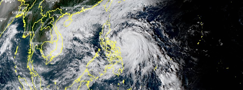
Featured image: Tropical Storm "Vamco" at 07:20 UTC on November 10, 2020. Credit: JMA/Himawari-8, RAMMB/CIRA
Tropical Storm "Vamco" formed on November 9, 2020, as the 22nd named storm of the 2020 Pacific typhoon season. The system entered the Philippine Area of Responsibility (PAR) at 12:00 UTC on November 8, receiving the name Ulysses — still as a tropical depression. By 12:00 UTC on November 10, Vamco intensified into a Severe Tropical Storm. The Office of Civil Defense (OCD) has raised a red alert status in Bicol Region (Region 5).
At 09:00 UTC (17:00 LT) on November 10, Tropical Storm "Vamco" (Ulysses) was located about 930 km (580 miles) east-southeast of Manila, Philippines.
Its maximum 10-minute sustained winds were 85 km/h (50 mph), maximum 1-minute sustained winds 75 km/h (45 mph), with gusts up to 120 km/h (75 mph).
The minimum central barometric pressure was 994 hPa, and the system was moving northwestward at 20 km/h (13 mph).
According to PAGASA, the center of Vamco is more likely to make landfall over Quezon early Thursday morning, November 12, with a close approach of Catanduanes and Camarines Norte tomorrow afternoon and evening (LT), respectively.
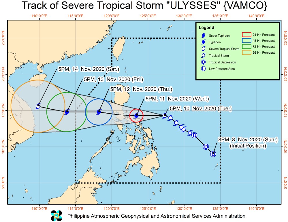
Image credit: PAGASA
However, a slight southward shift in the orientation of the track forecast shows an increasing likelihood of landfall over Camarines Norte tomorrow afternoon or evening.
Vamco may rapidly intensify into a typhoon by November 11 and reach a peak intensity of 130 to 150 km/h (80 – 93 mph) before the end of the day, PAGASA said.
"Landfall at or near peak intensity is highly likely."
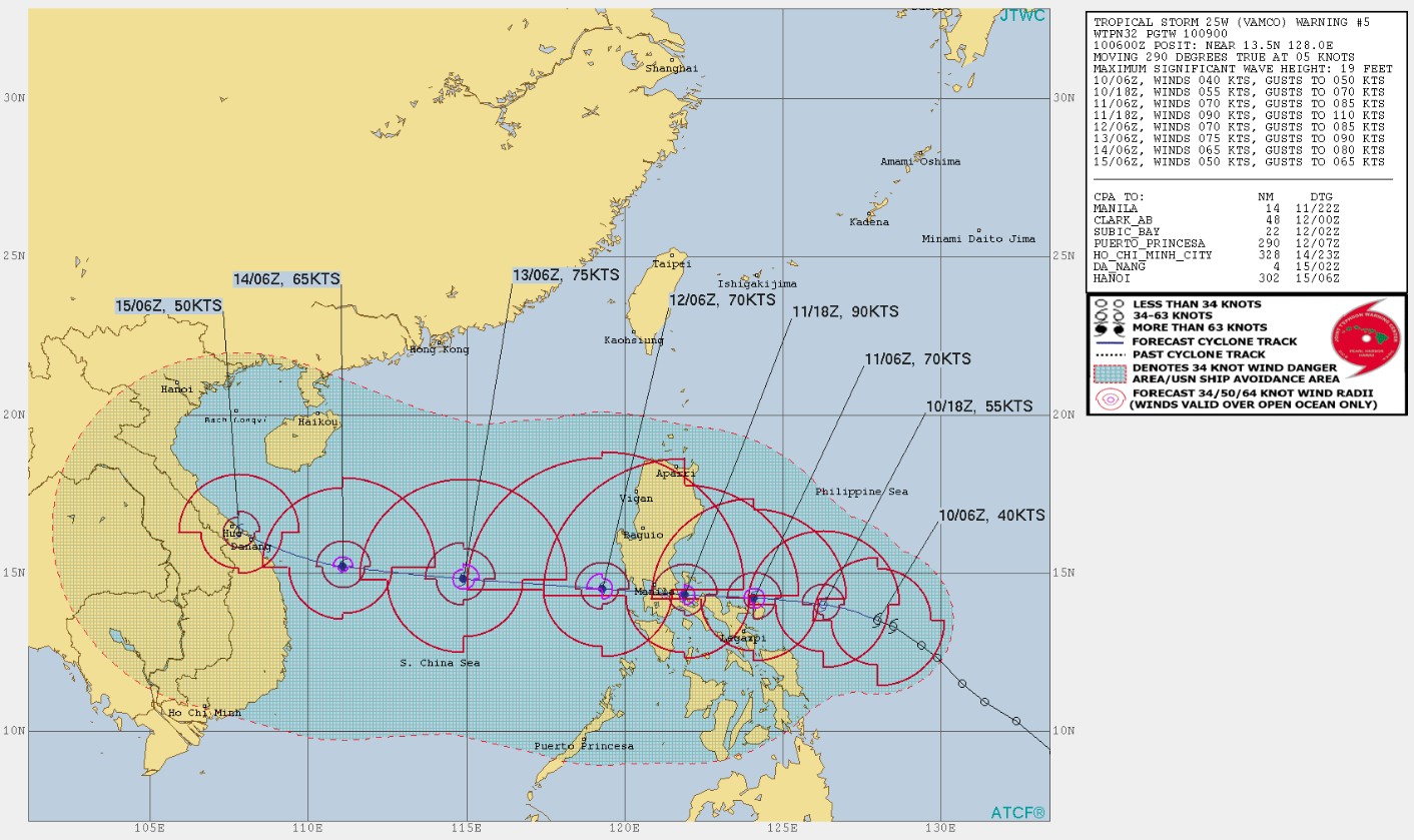
Image credit: JTWC
Areas under Tropical Cyclone Wind Signals (TCWS) #2 — Luzon — will be experiencing damaging gale- to storm-force winds while those under TCWS #1 — Luzon, Visayas — will have a strong breeze to near gale conditions during the passage of the tropical cyclone. Based on the intensity forecast, the highest wind signal to be hoisted during the passage of this storm will be TCWS #3.
Today, November 10, the tail-end of a cold front (shear line) will bring light to moderate with at times heavy rains over Cagayan including Babuyan Islands, Isabela, Apayao, and Ilocos Norte. Light to moderate with at times heavy rains will also be experienced over Aurora, Quezon, Bicol Region, Eastern and Central Visayas, Caraga, Northern Mindanao, Zamboanga Peninsula, and Bangsamoro.
Moderate to heavy rains associated with the rainbands of Vamco will begin affecting Bicol Region, portions of Quezon, and Samar Provinces tomorrow early morning (LT).
Tropical Storm "Vamco" at 07:20 UTC on November 10, 2020. Credit: JMA/Himawari-8, RAMMB/CIRA
Flooding (including flash floods), rain-induced landslides, and sediment-laden streamflows (i.e. lahar) may occur during heavy or prolonged rainfall especially in areas that are highly or very highly susceptible to these hazards and/or those that received significant antecedent rainfall.
Over the next 48 hours, there is a moderate to high risk of a storm surge of 1 to 2 m (3.3 – 6.6 feet) over the coastal areas of CALABARZON, Aurora, Camarines Provinces, Catanduanes, Albay, Metro Manila, Bulacan, Pampanga, Bataan, Romblon, and Marinduque, the western coastal area of Masbate including Burias Island, and the northern coastal areas of Occidental Mindoro and Oriental Mindoro including Lubang Island.
These storm surges, which may be accompanied by swells and breaking waves reaching the coast can cause life-threatening and damaging coastal inundation.
Over the next 24 hours, rough to very rough seas (2.5 to 5 m / 8.2 – 16.4 feet) will be experienced over the entire seaboards of Northern Luzon and the seaboards of Kalayaan Islands due to the surge of the Northeast Monsoon.
Meanwhile, Vamco will also bring rough to very rough seas (2.5 to 6 m / 8.2 – 19.6 feet) over the seaboards of areas under TCWS and the eastern seaboard of Eastern Samar (that are not under TCWS). Sea travel is risky over these waters, especially for mariners of small seacrafts.
Moderate to rough seas will be experienced over the remaining seaboards of the country. Mariners of small seacrafts are advised to take precautionary measures when venturing out to sea. Inexperienced mariners should avoid navigating in these conditions, PAGASA said.
The Office of Civil Defense (OCD) has raised a red alert status in the Bicol, still reeling from destruction brought by Super Typhoon "Goni" — locally known as Rolly.
OCD-Bicol regional director, Claudio Yucot, said all response assets and agencies of the Bicol regional disaster risk reduction and management council are already on standby.
A 'no sail' policy was implemented for fisherfolks and the pre-emptive evacuation for residents in low-lying and high areas which may be affected by flash floods and landslides, the Manila Bulletin reports.
Yucot advised all local DRRM councils to 'explore all means of communicating advisories to the communities' since some areas were still experiencing power interruption and limited mobile and internet connection caused by Super Typhoon "Goni."
I'm a dedicated researcher, journalist, and editor at The Watchers. With over 20 years of experience in the media industry, I specialize in hard science news, focusing on extreme weather, seismic and volcanic activity, space weather, and astronomy, including near-Earth objects and planetary defense strategies. You can reach me at teo /at/ watchers.news.
Commenting rules and guidelines
We value the thoughts and opinions of our readers and welcome healthy discussions on our website. In order to maintain a respectful and positive community, we ask that all commenters follow these rules.