
Sally rapidly strengthens into a Category 2 hurricane, extremely dangerous storm surge expected, U.S.
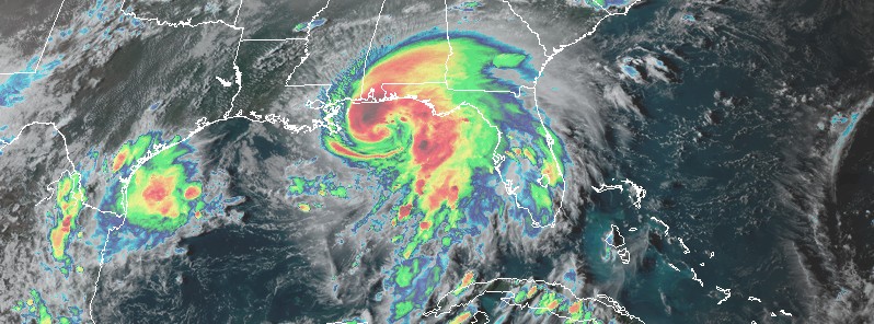
Featured image: Hurricane "Sally" at 22:00 UTC on September 14, 2020. Credit: NOAA/GOES-16, RAMMB/CIRA
Tropical Storm "Sally" has rapidly strengthened into a hurricane by 16:00 UTC on September 14, 2020, becoming the 7th hurricane of the 2020 Atlantic hurricane season. At the time, its center was located about 220 km (135 miles) ESE of the Mouth of the Mississippi River. It had maximum sustained winds of 140 km/h (85 mph) and minimum central pressure of 985 hPa.
By 21:00 UTC, Sally's center was located about 170 km (105 miles) E of the Mouth of the Mississippi River and 230 km (145 miles) SE of Biloxi, Mississippi.
Maximum sustained winds increased to 155 km/h (100 mph) and minimum central pressure to 987 hPa. This made Sally a Category 2 hurricane.
The system is moving WNW at 9 km/h (6 mph).
Additional strengthening is forecast tonight and early Tuesday and Sally is expected to be a dangerous hurricane when it moves onshore along the north-central Gulf Coast, NHC warns.
A Storm Surge Warning is in effect for:
– Port Fourchon, Louisiana to the Okaloosa/Walton County Line, Florida
– Lake Pontchartrain, Lake Maurepas, and Lake Borgne
– Mobile Bay
A Hurricane Warning is in effect for:
– Morgan City, Louisiana to the Navarre, Florida
– Lake Pontchartrain and Lake Maurepas including metropolitan New Orleans
A Tropical Storm Warning is in effect for:
– East of Navarre, Florida to Indian Pass, Florida
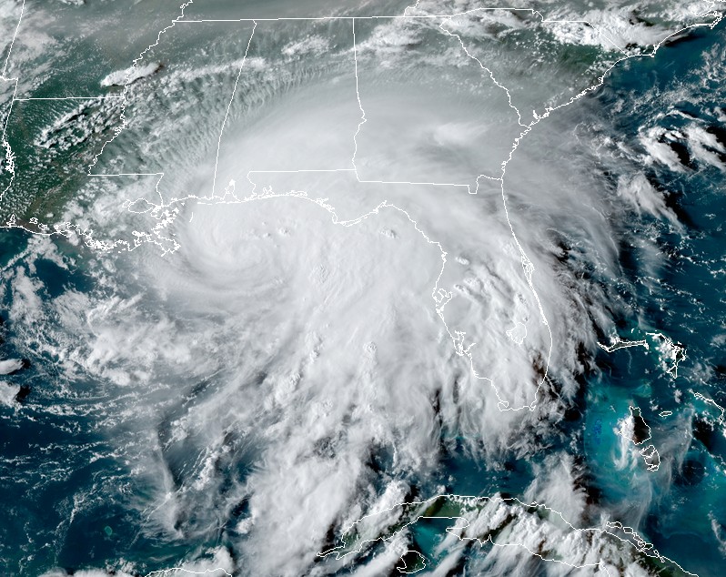
Hurricane "Sally" at 22:00 UTC on September 14, 2020. Credit: NOAA/GOES-16, RAMMB/CIRA
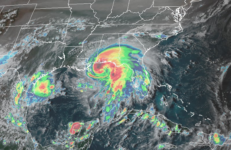
Hurricane "Sally" at 22:00 UTC on September 14, 2020. Credit: NOAA/GOES-16, RAMMB/CIRA
On the current NHC forecast track, the center of Sally will move near the coast of southeastern Louisiana tonight and Tuesday, September 15, and make landfall in the hurricane warning area late Tuesday or Wednesday.
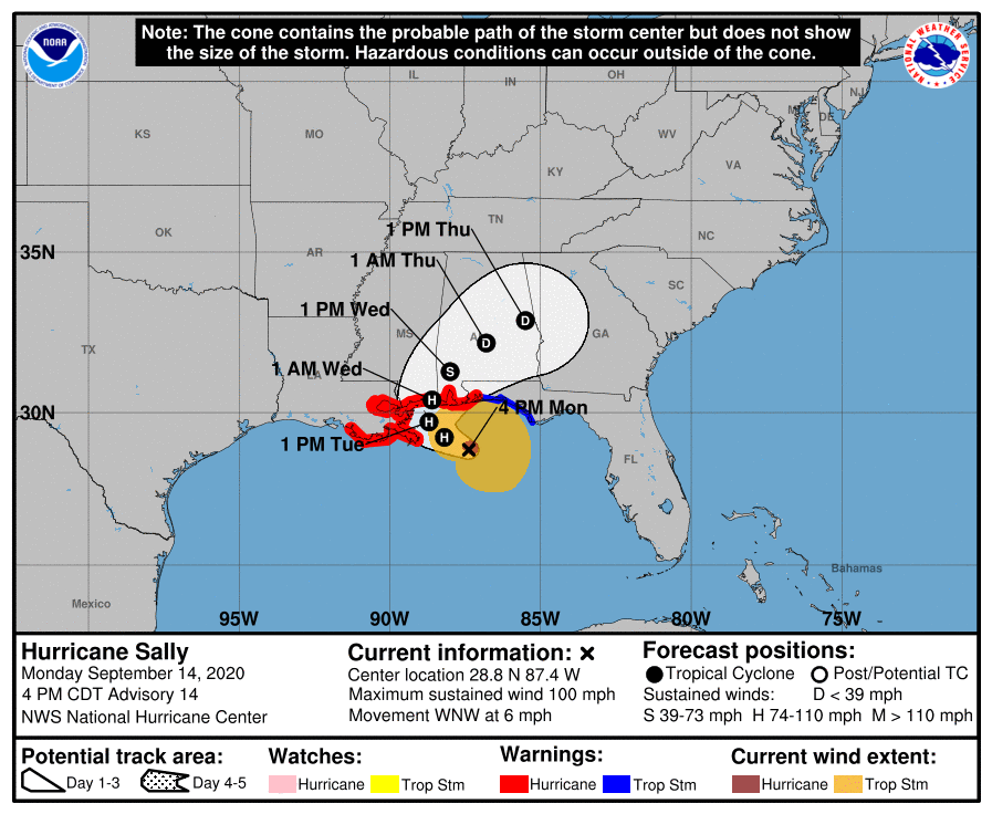
According to the NHC, it is too early to determine where Sally's center will move onshore given the uncertainty in the timing and location of Sally's northward turn near the central Gulf Coast. Users should not focus on the details of the official forecast track, since NHC's average forecast error at 36 to 48 hours is around 95 – 130 km (60 to 80 miles), and dangerous storm surge, rainfall, and wind hazards will extend well away from the center.
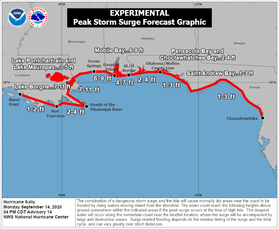
An extremely dangerous and life-threatening storm surge is expected for areas outside the southeastern Louisiana Hurricane and Storm Damage Risk Reduction System from Port Fourchon, Louisiana, to the Okaloosa/Walton County Line in the Florida Panhandle, where a Storm Surge Warning is in effect. Residents in these areas should follow any advice given by local officials.
Hurricane conditions are expected late tonight or early Tuesday within the Hurricane Warning area in southeastern Louisiana and are expected by late Tuesday and Tuesday night within the Hurricane Warning area along the Mississippi and Alabama coastlines and the western Florida Panhandle. Tropical storm conditions are likely to begin this evening in these areas and preparations should be rushed to completion.
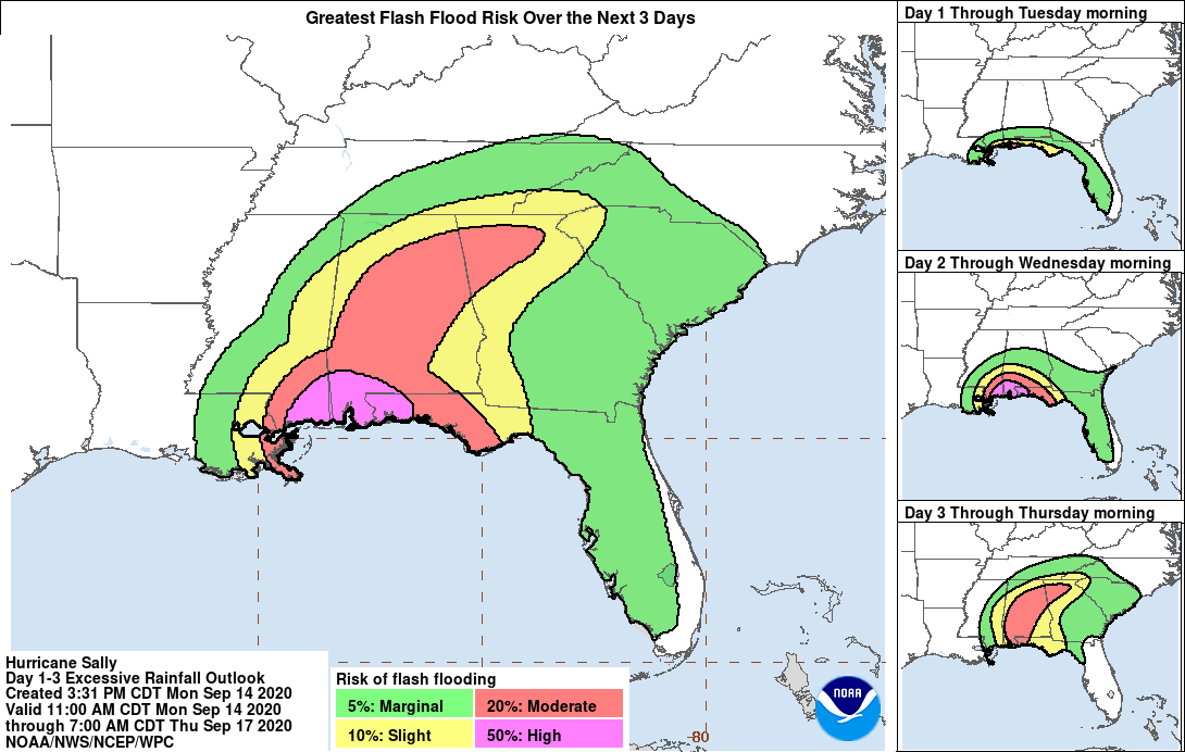
Life-threatening flash flooding is likely, as well as widespread minor to isolated major flooding, on area rivers along and just inland of the Central Gulf Coast. Significant flash and urban flooding, as well as widespread minor to moderate river flooding, is likely across Mississippi and Alabama through the middle of the week. Flooding impacts are expected to spread farther across the Southeast through the week. Sally could continue to produce flash flooding across the Florida peninsula and prolong existing minor river flooding across west-central Florida through today.
Storm surge is already causing flooding along the shores of Florida, Mississippi, Alabama, and Louisiana, AccuWeather reports. "Some areas could remain underwater for an extended period of time as storm surge continues and heavy, flooding rainfall moves inland."
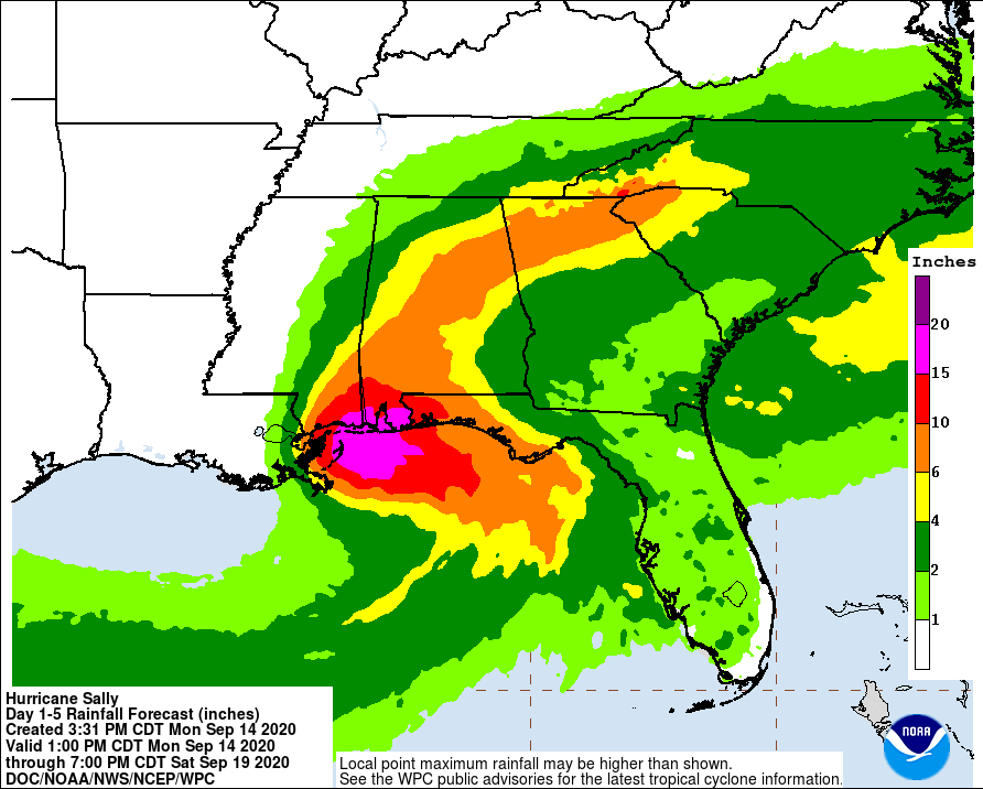
Sally is expected to be a slow-moving system as it approaches land, producing 200 – 400 mm (8 to 16 inches) of rainfall with isolated amounts of 600 mm (24 inches) over portions of the central Gulf Coast from the western Florida Panhandle to far southeast Louisiana through the middle of the week.
"Life-threatening flash flooding is likely," NHC warns. "In addition, this rainfall will likely lead to widespread minor to isolated major flooding on area rivers."
As Sally moves in farther inland early Wednesday, and tracks across the Southeast, 100 – 200 mm (4 to 8 inches) of rain is expected, with isolated maximum amounts of 300 mm (12 inches), across portions of eastern Mississippi, central Alabama, northern Georgia and the western Carolinas.
Significant flash and urban flooding is likely, as well as widespread minor to moderate flooding on some rivers.
Outer bands of Sally are expected to produce additional rainfall of 25 – 75 mm (1 to 3 inches) across the Florida peninsula today, September 14. This rainfall may produce flash and urban flooding and prolong high flows and ongoing minor flooding on rivers across central Florida.
A tornado or two are possible through tonight over coastal areas of the Florida Panhandle and southern Alabama.
The threat of tornadoes is expected to increase on Tuesday in these areas, as well as over parts of southern Mississippi and extreme southeast Louisiana.
I'm a dedicated researcher, journalist, and editor at The Watchers. With over 20 years of experience in the media industry, I specialize in hard science news, focusing on extreme weather, seismic and volcanic activity, space weather, and astronomy, including near-Earth objects and planetary defense strategies. You can reach me at teo /at/ watchers.news.
Commenting rules and guidelines
We value the thoughts and opinions of our readers and welcome healthy discussions on our website. In order to maintain a respectful and positive community, we ask that all commenters follow these rules.