
Two damaging tornadoes rip through southwestern Ontario, Canada
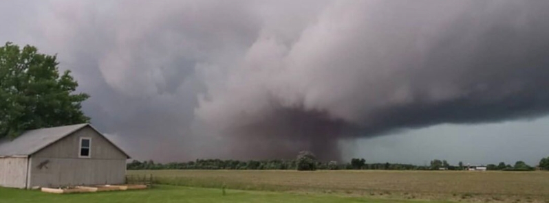
Image credit: @sydniehilll/Twitter
Two tornadoes touched down and caused significant damage in southwestern Ontario on Wednesday night, June 10, 2020. Environment Canada confirmed the first one in Glencoe, which struck around 23:20 UTC (19:20 LT) with winds of up to 120 km/h (75 mph). The second twister, classified as EF-1 with maximum winds of 150 km/h (93 mph), tore through the Belmont area at around 00:30 UTC (20:30 LT).
In the Belmont area, the path length of the tornado was 18 km (11 miles) with a maximum width of 250 m (820 feet). In the Glencoe area, there were a lot of reports of damage to trees and buildings, including a destroyed barn.
The winds resulted in widespread significant tree damage in Bracebridge, with many trees uprooted or snapped. Power was also disrupted to numerous customers as utility poles were damaged. Minor roof damage occurred to some homes, as well as damage to barns and other farm buildings.
Power outages also occurred in Muskoka and Windsor. Other areas that reported tree damage were LaSalle, Blyth, Goderich, St. Joseph, Huron County, Leamington, Barrie, Innisfil, St. Thomas, South London, and Oshawa.
"Metal flying through the air at the intersection just as I was coming, so I stomped on the gas, got home. And at that time my barn was just kind of coming apart so I ran in the house, and I told my family to get to the basement," a London resident said.
"I’m alive. The tree could have come down on the house, it’s right beside the house, and I’m just lucky to be alive," another homeowner remarked.
Chatham Kent Municipal Airport recorded wind gusts of 120 km/h (75 mph) at 23:21 UTC (19:21 LT), Ridgetown 96 km/h (60 mph) at 23:35 UTC (19:35 LT), Muskoka Airport 102 km/h (63 mph) at 23:42 UTC (19:42 LT), and Billy Bishop Toronto City Airport 89 km/h (55 mph) at 02:32 on June 11 (23:32 LT on June 10).
Environment Canada noted that the summary report "may contain preliminary or unofficial information and does not constitute a complete or final report."
Had the pleasure of seeing this fun stuff outside of Glencoe @weathernetwork #onstorm pic.twitter.com/M9Mb57EPRU
— ѕуd (@sydniehilll) June 11, 2020
This video was taken about a minute earlier. #tornado #onstorm #belmont pic.twitter.com/vS0clEHTUR
— Anthony Farnell (@AnthonyFarnell) June 11, 2020
It was a fun storm, I hope everyone’s safe #TORNADOWARNING pic.twitter.com/t27GnhyFPF
— ѕуd (@sydniehilll) June 11, 2020
Tornado on the south side of Belmont, Ontario. #onstorm pic.twitter.com/5CByp8neeO
— Anthony Farnell (@AnthonyFarnell) June 11, 2020
Researchers have started surveying the damage in the affected fields. Connell Miller, a research engineer with the North Tornadoes Project at Western University, said the path of destruction in the Belmont area seemed to be longer than what was initially reported. It also appears to be a bit stronger.
"We're finding barns where some of the walls have a total collapse. So, I can't say for certain what it is, but it is longer than I expected."
Miller added that he is also seeing a lot more damage to crops and fields than to structure. "So far, we've been to four or five places that have damage."
Despite the widespread damage, there were no reports of injuries from both tornadoes.
Commenting rules and guidelines
We value the thoughts and opinions of our readers and welcome healthy discussions on our website. In order to maintain a respectful and positive community, we ask that all commenters follow these rules.