
Powerful Storm Dennis set to batter northern Europe just days after Ciara
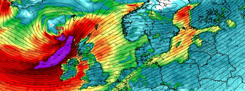
Image credit: @CIBBIE_VLOGS/Twitter
A new powerful storm named Dennis by the U.K. Met Office is set to hit northern Europe over the weekend– just a couple of days after Storm Ciara slammed several countries in the northwest, claiming lives of 8 people and leaving nearly 1 million homes without power. Dennis is the 14th named storm of the 2019/20 European windstorm season.
Dennis underwent rapid cyclogenesis early Thursday morning, February 13 as it moved across the North Atlantic Ocean. Its central pressure dropped for 46 hPa over a 24-hour period which is nearly 2 times more than what is needed for a cyclone to be considered a 'bomb cyclone.'
Furthermore, forecast models suggest that the central pressure of Storm Dennis will fall below 930 hPa when it's south of Iceland by Friday, February 14, or the day after.
If the pressure falls lower, the storm will be more intense, making Storm Dennis one of the most powerful North Atlantic storms on record, according to weather historian Christopher Burt and British weather historian Stephen Burt of Weather Underground.
"The system will develop in the North Atlantic before tracking eastward towards the U.K. and Ireland over the coming days, passing to the north of Scotland on Saturday," said Met Office.
According to AccuWeather, wind and rain will increase on Saturday morning as the storm approaches the Atlantic, with the heaviest rainfall expected Ireland into Northern Ireland and western Scotland.
Waves of up to 15 m (50 feet) high will be widespread near the center of the powerful storm with the potential for some waves to top the 15-m mark. The tallest waves will remain at sea, but the Atlantic-facing coastlines of the U.K. will be hammered by unrelenting waves as the center of Dennis nears the region.
A Severe Weather Warning for wind has been issued for most of England and Wales, while further warnings are likely to be issued in the following days.
#StormDennis arrives this weekend. It isn't expected to be quite as windy as last weekend, but rainfall could be more problematic#StormCiara brought 178 mm of rain to Cumbria in just 24 hours which is more than the February average of 112 mm #WednesdayWisdom pic.twitter.com/stEyH4SIuO
— Met Office (@metoffice) February 12, 2020
Warnings have been issued ahead of Storm Dennis this weekend. Strong winds and rain heading this way. Stay tuned for updates. #StormDennis pic.twitter.com/MQhAR4OQGT
— Barra Best (@barrabest) February 12, 2020
. #StormDennis is on the way for Saturday
We have 2 areas of low pressure before then-Wind & rain Thurs & Fri
Storm Dennis arrives on Saturday with heavy rain & severe gales
Warnings
Heavy rain up to 100-120mm for W Eng & Wales
Winds up to 60-70mph
Disruption likely pic.twitter.com/7tfElJSoXH— Laura Tobin (@Lauratobin1) February 13, 2020
On February 8, Storm Ciara left a trail of destruction across northwestern Europe, cutting power to nearly 1 million residents, causing widespread flooding, disrupting travel, and killing at least 8 people.
This makes flooding a major concern, as rainfall is expected to average 25 to 50 mm (1 to 2 inches) across Ireland and the U.K., with a maximum of 100 mm (4 inches).
Severe flooding in the worst-hit areas may also lead to road closures and damage to homes and businesses, AccuWeather warned.
The storm's impacts "will be far-reaching, impacting other areas of Europe recently pounded by stormy conditions," the agency said.
"Locations from northern France into Belgium, Netherlands, Denmark, and Germany will be lashed by rain and powerful winds from Dennis on Saturday night and Sunday."
The Icelandic Met Office issued an Orange weather alert (effective February 14) for Reykjavik – Capital Region, South Iceland, Faxafloi – Southwest Iceland, Breidafjordur – Westnorthwest Iceland, Westfjords, Northwest Iceland, Northeast Iceland, East Iceland, Eastfjords, Southeast Iceland and Central highlands – Uninhabited part of Iceland.
In Reykjavik, extremely windy with violent gust in higher elevation suburbs and also on routes that lead out of the city, e.g. at Kjalarnes, Hellisheiði and on Reykjanesbraut," IMO said.
"Transport disturbances are likely during the weather and delay in air traffic. Damages due to flying debris are likely and construction workers are encouraged to secure construction sites. Higher sea levels are anticipated due to storm surge with the possibility of small boats being damaged or detached from the dock. People are advised to secure their neighborhood, fasten loose items and show caution. Traveling is not advised while the weather warning is in effect."
For other areas issued by IMO, visit IMO/Alerts.
Met Eireann also warned of periods of "very wet and windy weather, with some stormy conditions possible," particularly later Sunday into Monday, February 16 into 17.
Localized flooding and travel delays are predicted across northern Europe as the worst of the storm is set to affect the region.
Next week, lesser stormy weather is expected across the U.K. but "unsettled weather will still be around," said Met Office, while calmer conditions are forecast across northern Europe, said AccuWeather.
Commenting rules and guidelines
We value the thoughts and opinions of our readers and welcome healthy discussions on our website. In order to maintain a respectful and positive community, we ask that all commenters follow these rules.