
Unusual, record-breaking storm slams West Coast as extremely active weather pattern continues across much of the United States
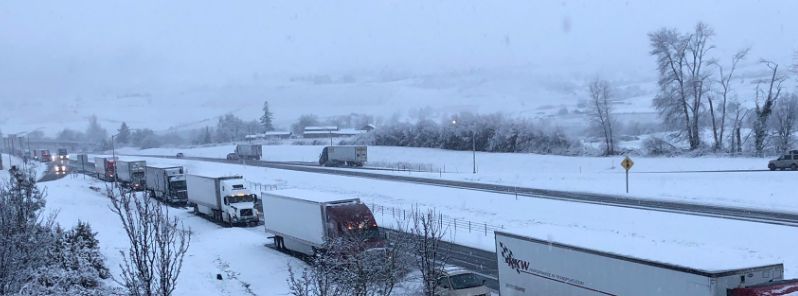
Image credit: @maggie_vespa/Twitter
Two powerful storms are affecting much of the United States this week, a strong surface low tracking across the Great Lakes toward New England and a historic 'bomb cyclone' which hit the West Coast on November 26 with a central pressure near 970 hPa, setting a new low pressure record for the month of November.
It's pretty unusual to see a storm like this hitting the West Coast, officials said.
Below-average temperatures are expected to continue for much of the central and western states.
The first storm is a strong surface low tracking eastward across the Great Lakes on Wednesday, November 27 and then towards New England by Wednesday night. Given the tight pressure gradient with this low pressure system, very windy conditions are likely across much of the Midwest and Ohio Valley region where winds could gust in excess of 80 km/h (50 mph) at times.
High wind warnings are in effect from the greater Kansas City area to western Ohio, and wind advisories farther south from Arkansas to the Mid-Atlantic region.
To the north of the surface low will be a swath of moderate to heavy snow across the Upper Midwest on Wednesday where winter storm warnings are in effect. Severe travel disruptions are likely for these areas.
The second storm reached the Oregon Coast Tuesday evening, November 26 as a low pressure record-setter for the month of November, with a central pressure near 970 hPa!
It is now beginning to gradually weaken as it moves inland towards the Great Basin. The Sierra Nevada mountains are likely to get hammered with blizzard conditions, and heavy snow is also expected towards the east to include the northern Rockies, Wasatch Range, and the San Juan Mountains of Colorado. Winter storm watches and warnings are already in effect for many of these areas.
Thanksgiving travel in these regions will also be severely affected, and local forecast offices have additional information pertaining to this.
The OR/CA storm peaked pressure-wise with a central pressure of 970 hPa/28.64" at 7 pm PST before slowly weakening. Here are its impacts thus far: pic.twitter.com/U4uHH0CBVW
— NWS WPC (@NWSWPC) November 27, 2019
As seen in the OPC 12Z Eastern #Pacific surface & #wind/#wave analyses & 1530Z GOES-17 infrared satellite image, the strong low pressure system over the Eastern Pacific has weakened to #gale force strength, but remains a formidable system. pic.twitter.com/KmJvmad8Au
— NWS OPC (@NWSOPC) November 27, 2019
#GOESWest recorded an intense #BombCyclone that formed off the coast of #Oregon and Northern #California on 11/26/2019. Heavy #snow, strong #winds, freezing #rain, & coastal #flooding will likely impact #Thanksgiving travel plans in some areas. Stay safe! https://t.co/gy5rPRZvTM pic.twitter.com/jtK6BlTpMv
— NOAA Satellites (@NOAASatellites) November 27, 2019
Storm update – 7:35 pm PST – Intense low pressure down to 972 mb just off the coast OR/CA. #CAwx #ORwx #BombCyclone pic.twitter.com/fvzXCsG1D1
— NWS Medford (@NWSMedford) November 27, 2019
Blizzard and high-wind warnings are in place across the western states, including Oregon, California, Nevada, and Idaho as a "historic, unprecedented" storm began dumping rain over the region since Tuesday, November 26.
"It's horrible out there. This is a very strong winter storm," said Shad Keene, a National Weather Service meteorologist in Medford, Oregon. "It's a historic event occurring right now."
A bomb cyclone is defined as a barometric pressure drop of 24 hPa in 24 hours. However, in this case, the bomb cyclone off coast dropped at least 24 hPa in 12 hours, Keene continued.
Californians were experiencing its effects as far south as the San Francisco Bay Area. "It's one of the lowest pressures to land on our coastline in history," Keene said, adding that the storm is causing widespread impacts. The low pressures from a bomb cyclone are the same as a Category 2 hurricane.
Major roadways remain closed at 15:00 UTC, Wednesday, including Interstate 80 and Highway 50. The closure came Tuesday afternoon, November 26, about five hours after the snow fell at Yreka, Weed, and other spots around 762 m (2 500 feet).
Interstate 5 was closed as well. Both directions of the state’s main north-south artery were closed north of Redding to Yreka, and could soon close at the Grapevine, the gateway to Los Angeles and points south.
Early Wednesday morning, the California Department of Transportation’s District 2 reported that the road would remain closed until all vehicles that had been stranded on the roadway on Tuesday were cleared, and crews were able to plow the road.
Good morning from Kingvale! Current highway closures noted below:
– I-80 WB from Truckee to Nyack
– SR-20 EB/WB from Nevada City to the 80 junction
– SR-49 NB/SB from Downieville to Sattley pic.twitter.com/57npRO1tOt— Caltrans District 3 (@CaltransDist3) November 27, 2019
Travelers headed toward Brownsville be prepared for winter-like weather as the snow is piling up. Units are already assisting with multiple spin outs and vehicles off the roadway. Please drive carefully. pic.twitter.com/KPTTH7fuHN
— CHP Yuba-Sutter (@ChpYuba) November 27, 2019
This. Is. CRAZY.
The #BombCyclone really delivered. I-5 is closed just south of Ashland, & these poor truckers are backed up for miles. They (along w/ a lot of Thanksgiving travelers) have been stuck since last night. No word from @OregonDOT yet on when the highway will reopen. pic.twitter.com/En3KP0I5lY
— Maggie Vespa KGW (@Maggie_Vespa) November 27, 2019
Department of Transportation officials in Oregon reported whiteout and blizzard conditions, warning drivers in affected roadways to pull over.
In Arizona, the weather service issued warnings of impossible travel conditions for Thursday and early Friday, November 28 to 29, with heavy and drifting snow.
225 PM (MST) – Details starting to become clearer as we draw closer to the Thanksgiving Holiday Winter Storm. We have narrowed down the time period where travel conditions are expected to be the worst. Now looking like like late afternoon Thursday through Friday morning. #azwx pic.twitter.com/qkie0jq4kX
— NWS Flagstaff (@NWSFlagstaff) November 26, 2019
In Santa Barbara County, officials said strong rains could cause dangerous debris flows at and below the areas affected this week by the Cave Fire.
"If you live or are near creeks and streams be aware that they may experience high flows and can rise quickly. If a debris flow occurs, and it is unsafe to leave, or you are unable to leave, go to high ground," the county said.
Furthermore, at least 481 flights to and from Denver had been canceled by early Tuesday afternoon. Airlines including American, Alaska, Delta, JetBlue, Frontier, Southwest, Spirit, and United have issued preliminary travel waivers to afflicted passengers. More cancellations could be possible as the storms rip through parts of the country.
Meanwhile, another severe storm has started hitting Midwest on November 27. A large swath of Minnesota, stretching from the Iowa border to the Twin Cities metro and up to the North Shore, remained under a winter storm warning.
Several schools canceled or delayed classes, including St. Paul Public Schools and the University of Minnesota Twin Cities campus.
The Minneapolis-St. Paul International Airport, where a few flights were delayed or canceled Wednesday, reported more than 203 mm (8 inches) of snow on November 27. Much of the canceled or delayed flights were to areas in Minnesota or other parts of the Upper Midwest.
According to the National Weather Service, the pre-Thanksgiving storm set a new record in the Twin Cities as the wettest year on record.
MSP set their all time wettest year on record with today's snowstorm. 40.81 inches so far in 2019. The previous record was 40.32 inches in 2016. #mnwx pic.twitter.com/EASNa2fa7X
— NWS Twin Cities (@NWSTwinCities) November 27, 2019
Heavy snow created slippery road conditions across parts of Minneapolis, resulting in widespread vehicular accidents.
Officials have then conducted snow removal operations on downtown Minneapolis on November 27, while the snow continued to blow, creating near blizzard conditions.
WCCO meteorologist Riley O’Connor said, "skies will start to clear Wednesday afternoon, leading to a chilly Thanksgiving on Thursday, when high temperatures look to only reach the upper 20s." There will be chances for snow with a wintry mix for Friday, November 29, and Saturday, November 30.
Had about one foot of snow yesterday here in the coastal range of Northern California. That was a big drop for so early in the year. Now for 3 very cold nights over the next 3 days. Then the forecast is for 8 days of rain moving off of the ocean. The area has gone from high fire danger to no fire danger in one day.