
Eruption at Mount Merapi ejects ash up to 11.6 km (38 000 feet) a.s.l., Aviation Color Code Red, Indonesia
Featured image: Eruption of Mount Merapi, Indonesia on June 1, 2018. Credit: Sutopo Purwo Nugroho
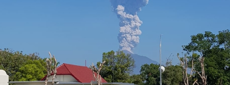
Indonesia's Mount Merapi erupted at 01:20 UTC (08:20 local time) on June 1, 2018, ejecting ash up to 11.6 km (38 000 feet) above sea level. The Aviation Color Code was raised to Red. Volcano's alert status remains unchanged at Level 2 as well as 3 km (1.8 miles) exclusion zone. The eruption lasted 2 minutes.
Residents living near the volcano are reminded not to enter exclusion zone and are encouraged to remain calm. "There is no need to evacuate as it is still safe," Sutopo Purwo Nugroho, spokesman for the national emergency agency said.
We do anticipate ashfall and residents are urged to be more alert, he said, adding that Adi Sucipto Yogyakarta International Airport is still open to flights.
The height of ash, based on a pilot report, is reaching 11.6 km (38 000 feet), the Darwin VAAC said in Volcanic Ash Advisory issued 08:25 UTC.
After 4 years of quiescence, Merapi entered its new eruptive phase with a powerful phreatic eruption at 00:30 UTC (07:30 local time) on May 11, 2018. This high-level eruption ejected ash up to 15 km (50 000 feet), forcing authorities to issue temporary evacuation orders for all residents living within 5 km (3 miles) of the crater.
Erupsi freatik gunungapi dapat terjadi tiba-tiba. Sulit dideteksi. Pascaerupsi Gunung Merapi tahun 2010 lalu hingga hingga saat ini status tetap Normal. Tidak ada indikasi peningkatan aktivitas vulkanik. Masyarakat sekitar Gunung Merapi juga lebih siap menghdapi erupsi. pic.twitter.com/tYAQenXDBn
— Sutopo Purwo Nugroho (@Sutopo_PN) May 11, 2018
Thousands of people are living on the flanks of Mount Merapi, active stratovolcano regularly erupting since 1948. It is located about 28 km (17 miles) north of Yogyakarta city (population 2.4 million).
In November 1994, a large explosion at the volcano produced pyroclastic flows that killed 27 people.
A series of eruptions in 2010 killed 353 people. Over 350 000 were evacuated.
Geological summary
Merapi, one of Indonesia's most active volcanoes, lies in one of the world's most densely populated areas and dominates the landscape immediately north of the major city of Yogyakarta. It is the youngest and southernmost of a volcanic chain extending NNW to Ungaran volcano. Growth of Old Merapi during the Pleistocene ended with major edifice collapse perhaps about 2000 years ago, leaving a large arcuate scarp cutting the eroded older Batulawang volcano.
Subsequently, the growth of the steep-sided Young Merapi edifice, its upper part unvegetated due to frequent eruptive activity, began SW of the earlier collapse scarp. Pyroclastic flows and lahars accompanying growth and collapse of the steep-sided active summit lava dome have devastated cultivated lands on the western-to-southern flanks and caused many fatalities during historical time.
I'm a dedicated researcher, journalist, and editor at The Watchers. With over 20 years of experience in the media industry, I specialize in hard science news, focusing on extreme weather, seismic and volcanic activity, space weather, and astronomy, including near-Earth objects and planetary defense strategies. You can reach me at teo /at/ watchers.news.
Commenting rules and guidelines
We value the thoughts and opinions of our readers and welcome healthy discussions on our website. In order to maintain a respectful and positive community, we ask that all commenters follow these rules.