
Research helps explain ongoing changes in geomagnetic field

Featured image: Lac Léman Summer Evening. Credit: PiConsti
Scientists from the University of Rochester used new data from sites in southern Africa to help explain recent and ongoing changes in Earth's magnetic field, best expressed by a deepening area of low field called the South Atlantic Anomaly. Their research extended the record of Earth’s magnetic field back thousands of years to the first millennium.
The strength of Earth's magnetic field has been decreasing at an alarming rate for the past 160 years. The region where it is weakest, and continuing to weaken, is a large area stretching from Chile to Zimbabwe called the South Atlantic Anomaly.
"We’ve known for quite some time that the magnetic field has been changing, but we didn’t really know if this was unusual for this region on a longer timescale, or whether it was normal,” says Vincent Hare, lead author of the new open access paper published in Geophysical Research Letters say.
In order to put these relatively recent changes into historical perspective, Rochester researchers led by professor John Tarduno gathered data from sites in southern Africa, which is within the South Atlantic Anomaly, to compile a record of Earth’s magnetic field strength over many centuries.
Data previously collected by Tarduno and research scientist Rory Cottrell, together with theoretical models developed by Eric Blackman, a professor of physics and astronomy at Rochester, suggest the core region beneath southern Africa may be the birthplace of recent and future pole reversals.
"We were looking for the recurrent behavior of anomalies because we think that’s what is happening today and causing the South Atlantic Anomaly," Tarduno says. "We found evidence that these anomalies have happened in the past, and this helps us contextualize the current changes in the magnetic field."
The researchers discovered that the magnetic field in the region fluctuated from 400 – 450 AD, from 700 – 750 AD, and again from 1225 – 1550 AD. This South Atlantic Anomaly, therefore, is the most recent display of a recurring phenomenon in Earth’s core beneath Africa that then affects the entire globe.
"We’re getting stronger evidence that there’s something unusual about the core-mantle boundary under Africa that could be having an important impact on the global magnetic field," Tarduno says.
Seismological data has revealed a denser region deep beneath southern Africa called the African Large Low Shear Velocity Province. The region is located right above the boundary between the hot liquid outer core and the stiffer, cooler mantle. Sitting on top of the liquid outer core, it may sink slightly, disturbing the flow of iron and ultimately affecting Earth’s magnetic field.
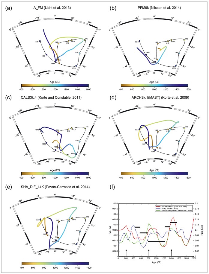
Comparison of Southern Africa paleomagnetic and archeomagnetic data of this study, combined with the data of Neukirch et al. (2012) and Tarduno et al. (2015), to the predicted geomagnetic field of five published field models. Paleomagnetic/archeomagnetic and field model predicted directions are reduced to a common site location (Mapungubwe: 22.212°S, 29.387°E). Color scale denotes age of data and corresponding model age values. Curve connecting site data is drawn for visual aid. (a) Stereonet projection of predicted geomagnetic field directions using the A_FM model (Licht et al., 2013) for 400 to 1600 CE and paleomagnetic/archeomagnetic directional data for Southern Africa during that interval. (b) PFM9k geomagnetic field model of Nilsson et al. (2014). (c) CALS3k.4 (Korte & Constable, 2011). (d) ARCH3k.1(MAST) (Korte et al., 2009). (e) SHA_DIF_14 K (Pavón–Carrasco et al., 2014). (f) Ratio of quadrupole to dipole energy components (〈Q〉/〈D〉) evolution over time using three geomagnetic field models (following Gallet et al. (2009)). Red dashed line: ARCH3k.1(MAST) (Korte et al., 2009); blue dashed line: A_FM (Licht et al., 2013); green dashed line: SHA_DIF_14 K (Pavón–Carrasco et al., 2014). Arrows show periods of archeomagnetic jerks in the archeointensity record (Gallet et al., 2009). Thick black bars show rates for changes of field direction observed in the paleomagnetic/archeomagnetic data for Southern Africa. Arrows are times of geomagnetic jerks as proposed by Gallet et al. (2009). Credit: Hare et al.
A major change in the magnetic field would have wide-reaching ramifications. Because the magnetic field stimulates currents in anything with long wires, including the electrical grid, changes in the magnetic field could cause navigation system malfunctions, satellite breakdowns and electrical grid failures, which, depending on the severity and how long we stay without electricity, could lead to a catastrophic cascading event and rapid civilization collapse. A weakening of the magnetic field also allows more cosmic radiation to reach Earth, affecting planet's climate system as well as human health.
Hare and Tarduno warn, however, that their data does not necessarily portend a complete pole reversal.
"We now know this unusual behavior has occurred at least a couple of times before the past 160 years, and is part of a bigger long-term pattern," Hare says. "However, it’s simply too early to say for certain whether this behavior will lead to a full pole reversal."
Even if a complete pole reversal is not in the near future, however, the weakening of the magnetic field strength is intriguing to scientists, Tarduno says. “The possibility of a continued decay in the strength of the magnetic field is a societal concern that merits continued study and monitoring."
References
- New Archeomagnetic Directional Records From Iron Age Southern Africa (ca. 425–1550 CE) and Implications for the South Atlantic Anomaly – Vincent J. Hare, John A. Tarduno, Thomas Huffman, Michael Watkeys, Phenyo C. Thebe, Munyaradzi Manyanga, Richard K. Bono, Rory D. Cottrell – OPEN ACCESS – Geophysical Research Letters – DOI: 10.1002/2017GL076007
- New data helps explain recent fluctuations in Earth’s magnetic field – University of Rochester (source)
I'm a dedicated researcher, journalist, and editor at The Watchers. With over 20 years of experience in the media industry, I specialize in hard science news, focusing on extreme weather, seismic and volcanic activity, space weather, and astronomy, including near-Earth objects and planetary defense strategies. You can reach me at teo /at/ watchers.news.
This is a good article, but how about more details on the travel the pole is experiencing? Where exactly is it located now?
I live in Port Angeles, WA, at 48.08 north latitude, and I have been trying to follow this phenomenon with simple compasses. But there is an issue with any data I collect. Due East of here about fifty miles is a topographical feature known as Iron Mountain. It is loaded with Molybdenum, which creates major issues in the magnetic field on a local basis. We have a 23 degree standard variation in our compass readings here. This is why the Trident Submarine Base was built at Bangor, which is about fifteen miles East of Iron Mountain, on the opposite side of the Hood Canal. It would play major havoc with any automated guidance system.
However, it appears to be playing games with my compass readings as well. At the moment, I’m either seeing a deviation of 31 degrees, or the pole is much further East than it used to be. I could also not know enough about what I am trying to do. Does anybody know either where the pole is now, or how to verify my data in a case like this? Any help would be highly appreciated.
WHY IS THERE NO UPDATED INFO ON WHERE THE MAGNETIC POLES ARE NOW? I HAVE JUST A CHEAP COMPASS AND HAVE BEEN TRACKING THE NORTH POLE IN MY AREA OF CANADA . I HAVE IT SHOWING DIRECT EAST OF ME IT WOULD BE HELPFUL TO KNOW WHERE IT IS NOW
Great post. Thank you.
Great article. Today was the first time I’ve read about the South Atlantic Anomaly. Good information and gives some more insights on the pole shift topic.