
Deadly M6.7 earthquake hits Greece – Turkey border region, triggers a tsunami
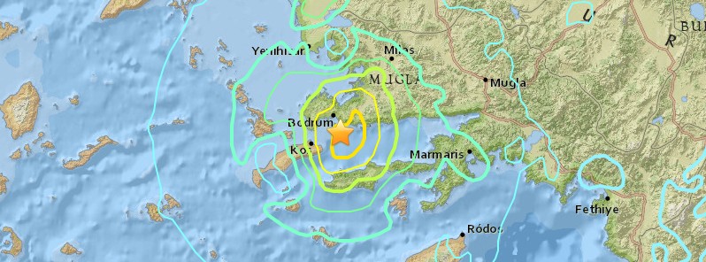
Image credit: USGS
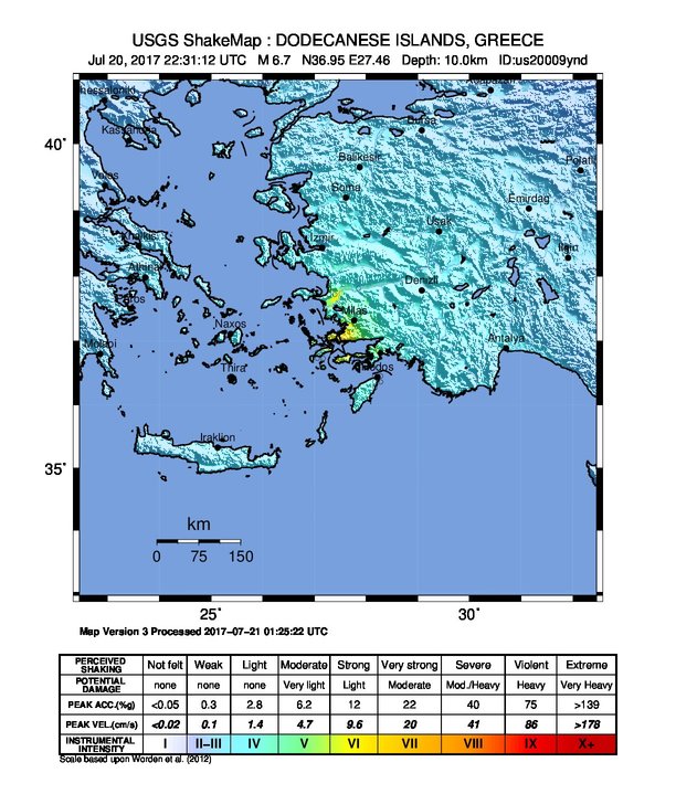
A strong and shallow earthquake registered by the USGS as M6.7 hit Dodecanese Islands, Greece – western Turkey border region at 22:31 UTC on July 20, 2017 (01:31 local time, July 21), triggering a small tsunami. The agency is reporting a depth of 10 km (6.2 miles). EMSC is reporting the same magnitude and depth. At least two people have been killed and more than 100 injured.
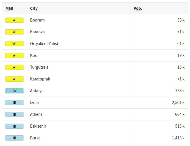
According to the USGS, the epicenter was located 10.3 km (6.4 miles) SSE of Bodrum (population 39 317), Turkey, 16.2 km (10.1 miles) ENE of Kos (population 19 224), Greece. 18.6 km (11.6 miles) ESE of Turgutreis (population 16 490), Turkey and 30.9 km (19.2 miles) NW of Datca (population 10 121), Turkey.
There are 875 264 people living within 100 km (62 miles), 44 000 are living within 10 km (6.2 miles).
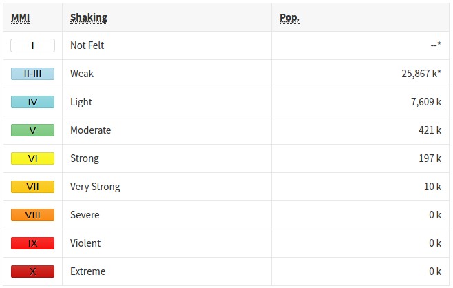
Some 10 000 people are estimated to have felt very strong shaking, 197 000 strong, and 421 000 moderate.
The quake triggered a small tsunami. It was powerful enough, however, to produce widespread damage to boats along the affected coasts.
EMSC registered more than 100 small to moderately strong aftershocks by 05:04 UTC. At least 17 of them were felt.
At least 2 people were killed when the ceiling of the building collapsed and more than 100 were injured on the Greek island of Kos. Two or three of the injured are in serious condition.
The island of Kos appears to be the worst-hit, with damaged buildings and a port and widespread minor damage (cracks in buildings, smashed windows and trashed shops).
"The rest of the island has no problem. It's only the main town that has a problem," Kos Mayor Giorgos Kyritsis said. "The buildings affected were mostly old, and were built before the earthquake building codes were introduced."
Ferry services were suspended due to damage at Kos's main port, where a 14th-century fortress also was damaged. A minaret from an old mosque also was damaged.
Esengul Civelek, governor of Mugla province in Turkey, said there were no casualties according to initial assessments. She said "there were minor injuries due to fear and panic."
In Bitez, a resort town about 6 kilometers (4 miles) west of Bodrum, the quake sent frightened residents running into the streets.
 The USGS issued a green alert for shaking-related fatalities. A yellow alert was issued for economic losses. Some damage is possible and the impact should be relatively localized. Estimated economic losses are less than 1% of GDP of Turkey. Past events with this alert level have required a local or regional level response.
Overall, the population in this region resides in structures that are a mix of vulnerable and earthquake resistant construction. The predominant vulnerable building types are unreinforced brick masonry and adobe block construction.
Recent earthquakes in this area have caused secondary hazards such as landslides that might have contributed to losses.
Estimated population exposure to earthquake shaking
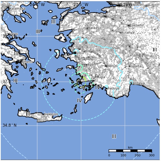
Shaking cities exposed
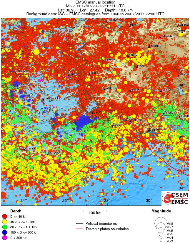
Regional seismicity
Multimedia
Seismotectonics of the Mediterranean region and vicinity
The Mediterranean region is seismically active due to the northward convergence (4-10 mm/yr) of the African plate with respect to the Eurasian plate along a complex plate boundary. This convergence began approximately 50 Ma and was associated with the closure of the Tethys Sea. The modern day remnant of the Tethys Sea is the Mediterranean Sea. The highest rates of seismicity in the Mediterranean region are found along the Hellenic subduction zone of southern Greece, along the North Anatolian Fault Zone of western Turkey and the Calabrian subduction zone of southern Italy. Local high rates of convergence at the Hellenic subduction zone (35mm/yr) are associated with back-arc spreading throughout Greece and western Turkey above the subducting Mediterranean oceanic crust. Crustal normal faulting throughout this region is a manifestation of extensional tectonics associated with the back-arc spreading. The region of the Marmara Sea is a transition zone between this extensional regime, to the west, and the strike-slip regime of the North Anatolian Fault Zone, to the east. The North Anatolian Fault accommodates much of the right-lateral horizontal motion (23-24 mm/yr) between the Anatolian micro-plate and Eurasian plate as the Anatolian micro-plate is being pushed westward to further accommodate closure of the Mediterranean basin caused by the collision of the African and Arabian plates in southeastern Turkey. Subduction of the Mediterranean Sea floor beneath the Tyrrhenian Sea at the Calabrian subduction zone causes a significant zone of seismicity around Sicily and southern Italy. Active volcanoes are located above intermediate depth earthquakes in the Cyclades of the Aegean Sea and in southern Italy.
In the Mediterranean region there is a written record, several centuries long, documenting pre-instrumental seismicity (pre-20th century). Earthquakes have historically caused widespread damage across central and southern Greece, Cyprus, Sicily, Crete, the Nile Delta, Northern Libya, the Atlas Mountains of North Africa and the Iberian Peninsula. The 1903 M8.2 Kythera earthquake and the 1926 M7.8 Rhodes earthquakes are the largest instrumentally recorded Mediterranean earthquakes, both of which are associated with subduction zone tectonics. Between 1939 and 1999 a series of devastating M7+ strike-slip earthquakes propagated westward along the North Anatolian Fault Zone, beginning with the 1939 M7.8 Erzincan earthquake on the eastern end of the North Anatolian Fault system. The 1999 M7.6 Izmit earthquake, located on the westward end of the fault, struck one of Turkey's most densely populated and industrialized urban areas killing, more than 17,000 people. Although seismicity rates are comparatively low along the northern margin of the African continent, large destructive earthquakes have been recorded and reported from Morocco in the western Mediterranean, to the Dead Sea in the eastern Mediterranean. The 1980 M7.3 El Asnam earthquake was one of Africa's largest and most destructive earthquakes within the 20th century.
Large earthquakes throughout the Mediterranean region have also been known to produce significant and damaging tsunamis. One of the more prominent historical earthquakes within the region is the Lisbon earthquake of November 1, 1755, whose magnitude has been estimated from non-instrumental data to be about 8.0. The 1755 Lisbon earthquake is thought to have occurred within or near the Azores-Gibraltar transform fault, which defines the boundary between the African and Eurasian plates off the west coast of Morocco and Portugal. The earthquake is notable for both a large death toll of approximately 60,000 people and for generating a tsunami that swept up the Portuguese coast inundating coastal villages and Lisbon. An earthquake of approximately M8.0 near Sicily in 1693 generated a large tsunami wave that destroyed numerous towns along Sicily's east coast. The M7.2 December 28, 1908 Messina earthquake is the deadliest documented European earthquake. The combination of severe ground shaking and a local tsunami caused an estimated 60,000 to 120,000 fatalities. (USGS)
I'm a dedicated researcher, journalist, and editor at The Watchers. With over 20 years of experience in the media industry, I specialize in hard science news, focusing on extreme weather, seismic and volcanic activity, space weather, and astronomy, including near-Earth objects and planetary defense strategies. You can reach me at teo /at/ watchers.news.
Commenting rules and guidelines
We value the thoughts and opinions of our readers and welcome healthy discussions on our website. In order to maintain a respectful and positive community, we ask that all commenters follow these rules.