
Manam volcano eruption forces evacuations, Papua New Guinea
Featured image: Manam eruption (1963). Credit: Wally Johnson, Australia Bureau of Mineral Resources
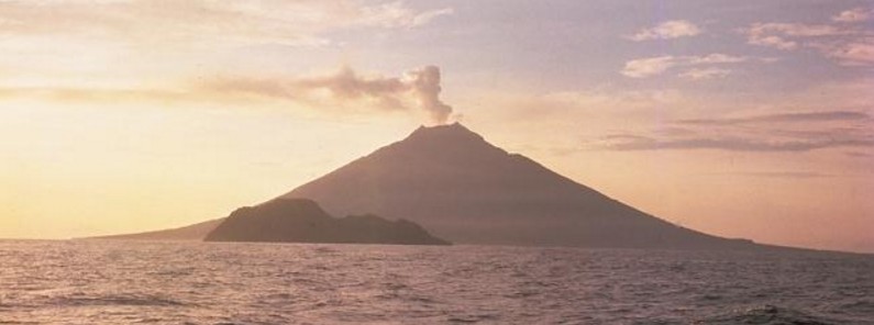
Papua New Guinea's Manam volcano erupted on April 16, 2017, forcing evacuations. The Aviation Color Code was raised to Orange.
According to local media reports, residents said the volcano began belching smoke and flames around 09:00 UTC (19:00 local time) Sunday night, April 16. The blasts have continued until Tuesday and the island is very dark, they said.
A local councilor, Paul Maburau, said many residents had taken refuge, with many choosing to leave the island.
Maburau said the fire was coming out of both craters, the one between Bokure village and Kaulang village, and the one between Dugulava and Warisi villages.
"Every time there was a blast, the ground would shake," he said. "The place is very dark with the smoke from the volcano."
According to Darwin VAAC VA Advisory released 22:15 UTC on April 16, the Rabaul Volcano Observatory reported a significant increase in volcanic activity. The Aviation Color Code was raised to Orange.
Manam is one of Papua New Guinea's most active volcanoes. A pyroclastic flow from the volcano on December 3, 1996, killed 13 people in the village of Budua.
Geological summary
The 10-km-wide island of Manam, lying 13 km off the northern coast of mainland Papua New Guinea, is one of the country's most active volcanoes. Four large radial valleys extend from the unvegetated summit of the conical 1807-m-high basaltic-andesitic stratovolcano to its lower flanks. These "avalanche valleys" channel lava flows and pyroclastic avalanches that have sometimes reached the coast. Five small satellitic centers are located near the island's shoreline on the northern, southern, and western sides.
Two summit craters are present; both are active, although most historical eruptions have originated from the southern crater, concentrating eruptive products during much of the past century into the SE valley. Frequent historical eruptions, typically of mild-to-moderate scale, have been recorded since 1616. Occasional larger eruptions have produced pyroclastic flows and lava flows that reached flat-lying coastal areas and entered the sea, sometimes impacting populated areas. (GVP)
I'm a dedicated researcher, journalist, and editor at The Watchers. With over 20 years of experience in the media industry, I specialize in hard science news, focusing on extreme weather, seismic and volcanic activity, space weather, and astronomy, including near-Earth objects and planetary defense strategies. You can reach me at teo /at/ watchers.news.
Commenting rules and guidelines
We value the thoughts and opinions of our readers and welcome healthy discussions on our website. In order to maintain a respectful and positive community, we ask that all commenters follow these rules.