
Highest resolution map of Earth’s lithospheric magnetic field
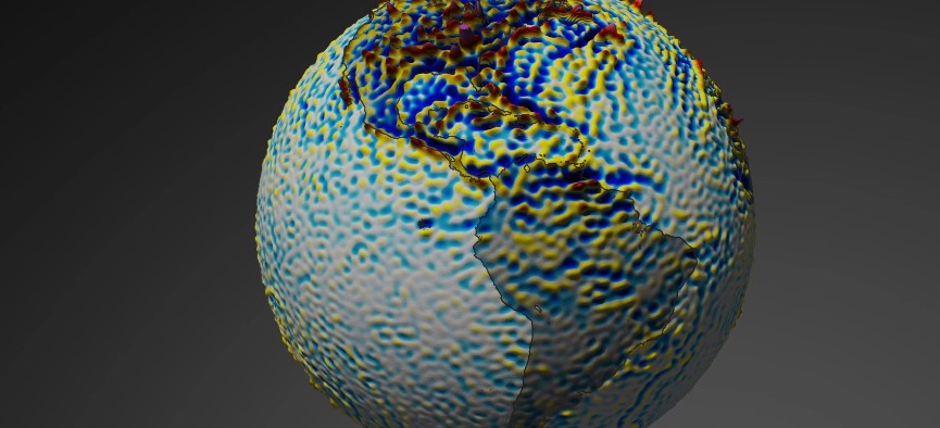
Image credit: ESA/DTU Space/DLR
After three years of collecting data, Swarm mission scientists have produced the highest resolution map of Earth’s lithospheric magnetic field from space to date. The dataset combines measurements from ESA’s Swarm satellites with historical data from the German CHAMP satellite using a new modeling technique that allowed scientists to extract tiny magnetic signals from Earth’s outer layer.
Most of the Earth's magnetic field is generated at depths greater than 3 000 km (1 860 miles) by the movement of molten iron in the outer core. The remaining 6% is partly due to electrical currents in space surrounding Earth, and partly due to magnetized rocks in the upper lithosphere – the rigid outer part of Earth, consisting of the crust and upper mantle.
Although this ‘lithospheric magnetic field’ is very weak and therefore difficult to detect from space, the Swarm satellite trio has been able to map its magnetic signal and after three years of collecting data, the highest resolution map of this field from space to date has been released.
“By combining Swarm measurements with historical data from the German CHAMP satellite, and using a new modeling technique, it was possible to extract the tiny magnetic signals of crustal magnetization,” explained Nils Olsen from the Technical University of Denmark, one of the scientists behind the new map.
“Understanding the crust of our home planet is no easy feat. We can’t simply drill through it to measure its structure, composition, and history. Measurements from space have great value as they offer a sharp global view on the magnetic structure of our planet’s rigid outer shell," ESA’s Swarm mission manager, Rune Floberghagen, added.
Presented at this week’s Swarm Science Meeting in Banff, Canada, the new map shows detailed variations in this field more precisely than previous satellite-based reconstructions, caused by geological structures in Earth’s crust.
One of these anomalies occurs in Central African Republic, centred around the city of Bangui, where the magnetic field is significantly sharper and stronger. The cause for this anomaly is still unknown, but some scientists speculate that it may be the result of a meteorite impact more than 540 million years ago.
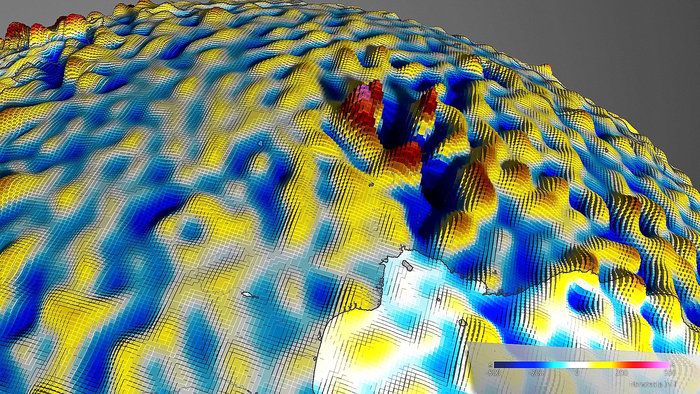
Latest map of the lithospheric magnetic field by Swarm shows detailed variations in this field more precisely than previous satellite-based reconstructions, caused by geological structures in Earth’s crust. One of these anomalies occurs in Central African Republic, centred on the city of Bangui, where the magnetic field is significantly sharper and stronger. The cause for this anomaly is still unknown, but some scientists speculate that it may be the result of a meteorite impact more than 540 million years ago. Credit: ESA/DTU Space/DLR
The magnetic field is in a permanent state of flux. Magnetic north wanders, and every few hundred thousand years the polarity flips so that a compass would point south instead of north.
When new crust is generated through volcanic activity, mainly along the ocean floor, iron-rich minerals in the solidifying magma are oriented towards magnetic north, thus capturing a ‘snapshot’ of the magnetic field in the state it was in when the rocks cooled.
Since magnetic poles flip back and forth over time, the solidified minerals form ‘stripes’ on the seafloor and provide a record of Earth’s magnetic history.
The latest map from Swarm gives us an unprecedented global view of the magnetic stripes associated with plate tectonics reflected in the mid-oceanic ridges in the oceans, ESA said in a statement.
“These magnetic stripes are evidence of pole reversals and analysing the magnetic imprints of the ocean floor allows the reconstruction of past core field changes. They also help to investigate tectonic plate motions,” said Dhananjay Ravat from the University of Kentucky in the USA. “The new map defines magnetic field features down to about 250 km (155 miles) and will help investigate geology and temperatures in Earth’s lithosphere.”
I'm a dedicated researcher, journalist, and editor at The Watchers. With over 20 years of experience in the media industry, I specialize in hard science news, focusing on extreme weather, seismic and volcanic activity, space weather, and astronomy, including near-Earth objects and planetary defense strategies. You can reach me at teo /at/ watchers.news.
Commenting rules and guidelines
We value the thoughts and opinions of our readers and welcome healthy discussions on our website. In order to maintain a respectful and positive community, we ask that all commenters follow these rules.