Massive M7.4 earthquake hits near Fukushima, tsunami warnings issued
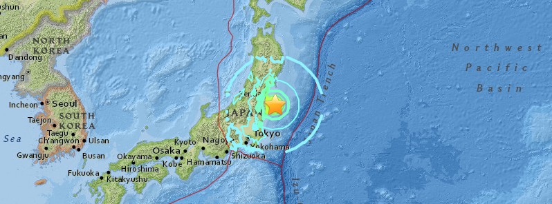
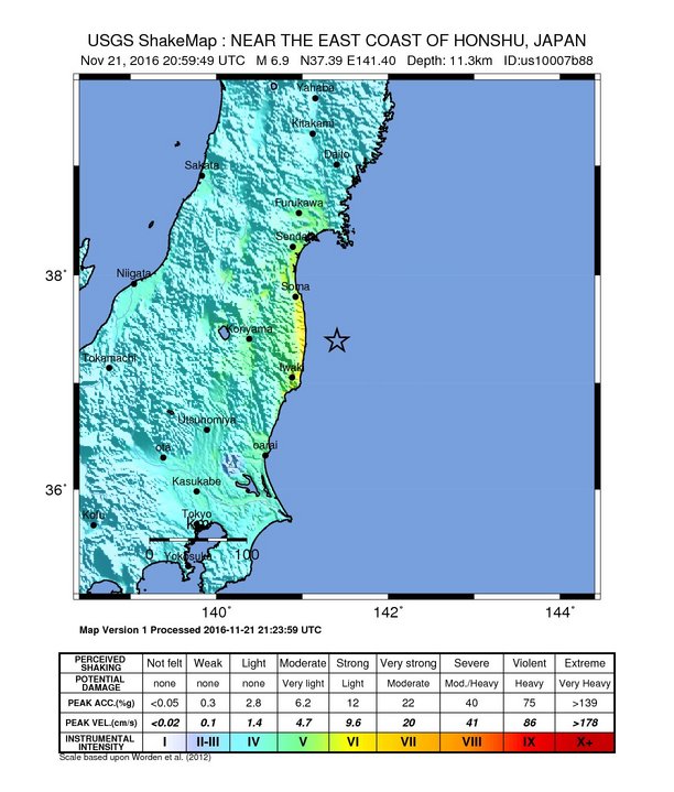
A very strong and shallow earthquake registered by the JMA as M7.3 (upgraded from M7.3) hit near the east coast of Honshu, Japan at 20:59 UTC on November 21, 2016. The agency is reporting a depth of 25 km (15.5 miles). USGS is reporting M6.9 (downgraded from M7.3) at a depth of 11.4 km (7 miles). Tsunami warnings are in place for Fukushima Prefecture.
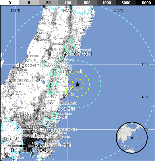
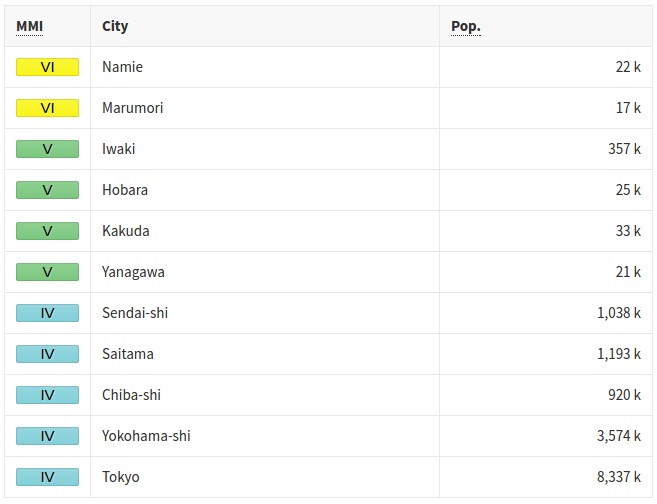
According to the USGS, the epicenter was located 37 km (23 miles) ESE of Namie (population 21 866), 59.7 km (37.1 miles) NE of Iwaki (population 357 309), 73.3 km (45.6 miles) E of Funehikimachi-funehiki (population 23 524), 80.9 km (50.3 miles) SE of Marumori (population 16 752), and 91.7 km (57 miles) ESE of Fukushima (294 237), Japan.
There are 702 984 living within 100 km (62 miles). About 5 000 people are living within 50 km (31 miles).
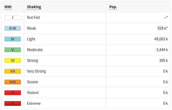
Parts of Fukushima and Ibaraki prefectures experienced JMA seismic intensity of 5- (many people are frightened and feel the need to hold onto something stable, dishes in cupboards and items on bookshelves may fall, unsecured furniture may move, and unstable furniture may topple over).
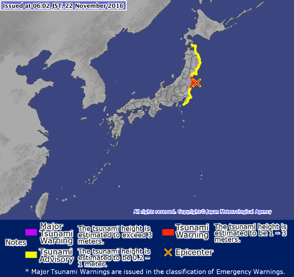
Tsunami warnings are in place for Fukushima Prefecture, JMA said. The estimated tsunami height is between 1 and 3 meters (3.28 to 9.84 feet).
Tsunami waves may reach their maximum height a few hours or more after initial waves.
Tsunami warning definition by JMA: Damage due to tsunami waves is expected. Evacuate immediately from coastal regions and riverside areas to a safer place such as high ground or an evacuation building. Tsunami waves are expected to hit repeatedly. Do not leave safe ground until the warning is lifted.
Tsunami advisories are in place for the following coastal regions of Japan:
- Pacific coast of Aomori Prefecture
- Iwate Prefecture
- Miyagi Prefecture
- Ibaraki Prefecture
- Kujukuri and Sotobo area, Chiba Prefecture.
JMA said tsunamis are expected to arrive imminently in the following coastal regions of Japan: Fukushima Prefecture.
| Tsunami Forecast Region | Category of Tsunami Warning/Advisory |
|---|---|
| FUKUSHIMA PREF. | TSUNAMI WARNING |
| PACIFIC COAST OF AOMORI PREF. | TSUNAMI ADVISORY |
| IWATE PREF. | TSUNAMI ADVISORY |
| MIYAGI PREF. | TSUNAMI ADVISORY |
| IBARAKI PREF. | TSUNAMI ADVISORY |
| KUJUKURI AND SOTOBO AREA, CHIBA PREF. | TSUNAMI ADVISORY |
PTWC said tsunami waves reaching 0.3 to 1 meters above the tide level are possible for some coasts of Japan.
ESTIMATED TIMES OF ARRIVAL
--------------------------

  * ESTIMATED TIMES OF ARRIVAL -ETA- OF THE INITIAL TSUNAMI WAVE
    FOR PLACES WITHIN THREATENED REGIONS ARE GIVEN BELOW. ACTUAL
    ARRIVAL TIMES MAY DIFFER AND THE INITIAL WAVE MAY NOT BE THE
    LARGEST. A TSUNAMI IS A SERIES OF WAVES AND THE TIME BETWEEN
    WAVES CAN BE FIVE MINUTES TO ONE HOUR.

    LOCATION         REGION             COORDINATES    ETA(UTC)
    ------------------------------------------------------------
    KATSUURA         JAPAN             35.1N 140.3E   2150 11/21
    KUSHIRO          JAPAN             42.9N 144.3E   2217 11/21
    HACHINOHE        JAPAN             40.5N 141.5E   2236 11/21
    SHIMIZU          JAPAN             32.8N 133.0E   2312 11/21
    NOBEOKA          JAPAN             32.5N 131.8E   2319 11/21

POTENTIAL IMPACTS
-----------------

  * A TSUNAMI IS A SERIES OF WAVES. THE TIME BETWEEN WAVE CRESTS
    CAN VARY FROM 5 MINUTES TO AN HOUR. THE HAZARD MAY PERSIST
    FOR MANY HOURS OR LONGER AFTER THE INITIAL WAVE.

  * IMPACTS CAN VARY SIGNIFICANTLY FROM ONE SECTION OF COAST TO
    THE NEXT DUE TO LOCAL BATHYMETRY AND THE SHAPE AND ELEVATION
    OF THE SHORELINE.

  * IMPACTS CAN ALSO VARY DEPENDING UPON THE STATE OF THE TIDE AT
    THE TIME OF THE MAXIMUM TSUNAMI WAVES.

  * PERSONS CAUGHT IN THE WATER OF A TSUNAMI MAY DROWN... BE
    CRUSHED BY DEBRIS IN THE WATER... OR BE SWEPT OUT TO SEA.
USGS issued a green alert for shaking-related fatalities and economic losses. There is a low likelihood of casualties and damage.
Overall, the population in this region resides in structures that are resistant to earthquake shaking, though some vulnerable structures exist.
Recent earthquakes in this area have caused secondary hazards such as landslides and fires that might have contributed to losses.
Estimated population exposure to earthquake shaking
Selected cities exposed
This article is based on preliminary data and is being updated.
Seismotectonics of Japan and Vicinity
The North America plate, Pacific plate, Philippine Sea plate, and Eurasia plate all influence the tectonic setting of Japan, Taiwan, and the surrounding area. Some authors divide the edges of these plates into several microplates that together take up the overall relative motions between the larger tectonic blocks, including the Okhotsk microplate in northern Japan, the Okinawa microplate in southern Japan, the Yangzee microplate in the area of the East China Sea, and the Amur microplate in the area of the Sea of Japan.
The seafloor expression of the boundary between the Pacific and North America plates lies 300 km off the east coasts of Hokkaido and Honshu at the Kuril-Kamchatka and Japan trenches. The subduction of the Pacific plate beneath the North America plate, at rates of 83-90 mm/yr, generates abundant seismicity, predominantly as a result of interplate slip along the interface between the plates. The 1958 M 8.4 Etorofu, 1963 M 8.6 Kuril, 2003 M 8.3 Tokachi-Oki, and the 2011 M 9.0 Tohoku earthquakes all exemplify such megathrust seismicity. The 1933 M 8.4 Sanriku-Oki earthquake and the 1994 M 8.3 Shikotan earthquake are examples of intraplate seismicity, caused by deformation within the lithosphere of the subducting Pacific plate (Sanriku-Oki) and of the overriding North America plate (Shikotan), respectively.
At the southern terminus of the Japan Trench the intersection of the Pacific, North America, and Philippine Sea plates forms the Boso Triple Junction, the only example of a trench-trench-trench intersection in the world. South of the triple junction the Pacific plate subducts beneath the Philippine Sea plate at the Izu-Ogasawara trench, at rates of 45-56 mm/yr. This margin is noteworthy because of the steep dip of the subducting Pacific plate (70° or greater below depths of 50 km depth), and because of its heterogeneous seismicity; few earthquakes above M 7 occur at shallow depths, yet many occur below 400 km. The lack of large shallow megathrust earthquakes may be a result of weak coupling at the plate interface, or simply a reflection of an incomplete earthquake catalog with respect to the length of typical seismic cycles.
The northernmost section of the Philippine Sea plate shares a 350 km boundary with the North America plate that runs approximately east-west from the Boso Triple Junction towards the Izu Peninsula. This short boundary is dominated by the subduction of the Philippine Sea plate beneath Japan along the Sagami Trough, but also includes small sections of transform motion.
The subduction of the Philippine Sea plate under the Eurasia plate begins at the Suruga Trough, immediately southwest of the Izu peninsula. In the northern Tōkai, Tonankai and Nankai sections of this subduction zone, historical data indicate M 8+ earthquake recurrence intervals of 100-150 years. The Tonankai and Nankai sections last ruptured in M 8.1 earthquakes in 1944 and 1946, respectively, while the Tōkai section last broke in 1854. In the 1980's studies began to forecast the imminence of a large earthquake in the Tōkai region, and warned of its potential impact on the cities of Tokyo and Yokohama (the two largest cities in Japan); to date, the expected event has not occurred.
The boundary between the Philippine Sea and Eurasia plates continues south and southwestwards from the Suruga Trough, extending 2000 km along the Nankai and Ryukyu trenches before reaching the island of Taiwan. Along the Ryukyu Trench, the Philippine Sea plate exhibits trench normal subduction at rates increasing from 48 mm/yr in the northeast to 65 mm/yr in the southwest. Convergence and the associated back-arc deformation west of the oceanic trench creates the Ryukyu Islands and the Okinawa Trough. The largest historic event observed along this subduction zone was the M 8.1 Kikai Island earthquake in 1911.
In the vicinity of Taiwan the structure of the Philippine Sea: Eurasia plate boundary and the associated pattern of seismicity becomes more complex. 400 km east of Taiwan a clockwise rotation in the trend of the margin (from NE-SW to E-W), paired with an increase in subduction obliquity creates a section of the plate boundary that exhibits dextral transform and oblique thrusting motions. South of Taiwan the polarity of subduction flips; the Eurasia plate subducts beneath the Philippine Sea plate. Debate surrounds contrasting models of the plate boundary position between the zones of oppositely verging subduction, and the boundary's relation to patterns of seismicity. Many studies propose that crustal thickening causes the majority of regional seismicity, while others attribute seismicity to deformation associated with subduction. Another resolution proposes a tear in the Philippine Sea plate and a complex assortment of subduction, transform, and collisional motion. All the models concede that seismicity around the island of Taiwan is anomalously shallow, with few earthquakes deeper than 70km.
While there are no instances of an earthquake M>8 in the modern record, Taiwan and its surrounding region have experienced eight M>7.5 events between 1900 and 2014. The dominance of shallow M<8 earthquakes suggests fairly weak plate boundary coupling, with most earthquakes caused by internal plate deformation. The 1935 M 7.1 Hsinchu-Taichung earthquake and the 1999 M 7.6 Chi-Chi Earthquake both exemplify the shallow continental crust thrust faulting that dominates regional seismicity across the island. A major tectonic feature of the island is the Longitudinal Valley Fault, which ruptures frequently in small, shallow earthquakes. In 1951, the Longitudinal Valley Fault hosted twelve M≥6 events known as the Hualien-Taitung earthquake sequence.
Large earthquakes in the vicinity of Japan and Taiwan have been both destructive and deadly. The regions high population density makes shallow earthquakes especially dangerous. Since 1900 there have been 13 earthquakes (9 in Japan, 4 in Taiwan) that have each caused over 1000 fatalities, leading to a total of nearly 200,000 earthquake related deaths. In January 1995 an earthquake that ruptured a southern branch of the Japan Median Tectonic Line near the city of Kobe (population 1.5 million) killed over 5000 people. The 1923 Kanto earthquake shook both Yokohama (population 500,000, at that time) and Tokyo (population 2.1 million), killing 142,000 people. The earthquake also started fires that burned down 90% of the buildings in Yokohama and 40% of the buildings in Tokyo. Most recently, the M9.0 Tohoku earthquake, which ruptured a 400 km stretch of the subduction zone plate boundary east of Honshu, and the tsunami it generated caused over 20,000 fatalities. (USGS) More information on regional seismicity and tectonics
Featured image credit: USGS
The correlation between the increase of Cosmic rays and geological upheaval is a well observed fact.
It is not a coincidence that this massive M7.4 earthquake which hits near Fukushima, Japan at 5:59 a.m. Tuesday, local time took place when solar activity was at a very low levels. According to NOAA, the solar disk was spotless on 20 and 21 of November and on the previous three days only two sunspots were observed. read the rest at https://www.linkedin.com/pulse/correlation-between-increase-cosmic-rays-geological-upheaval-shrair?trk=mp-reader-card