
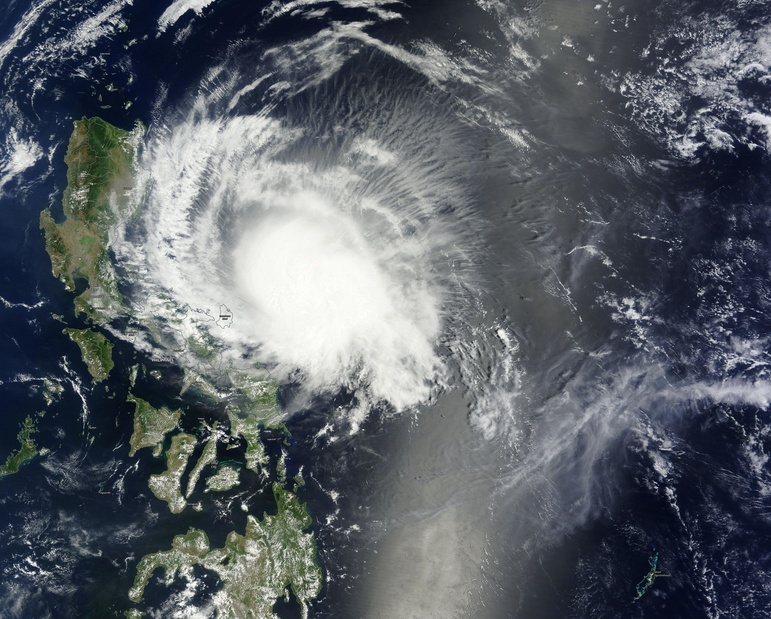
Typhoon “Maysak” (Chedeng) about to make landfall in southern Isabela, Philippines
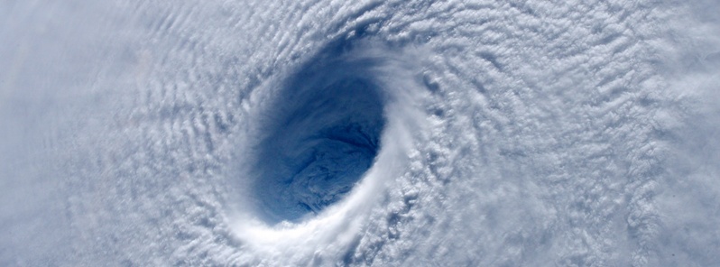
Image credit: Typhoon "Maysak" as seen from ISS on April 2, 2015. Taken by ESA astronaut Samantha Cristoforetti
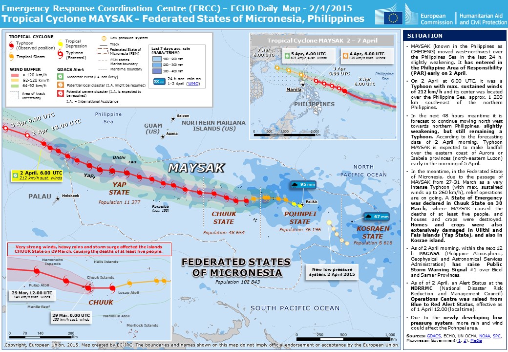
Typhoon "Maysak" (Chedeng) has accelerated slightly as it continues to move closer to Isabela-Aurora area, Philippines, state weather bureau PAGASA said today.
Maysak was a Super Typhoon with maximum sustained winds of 259 km/h (161 mph), and wind gusts up to 314 km/h (195 mph), when it passed northeast of Yap, Micronesia on March 31. The system started weakening on its approach to the Philippines as it encountered stronger upper level winds and dry air. It is expected to be downgraded into a tropical storm before it hits the Philippines.
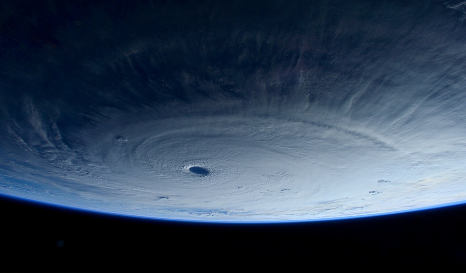
Typhoon "Maysak" as seen from ISS. Taken by ESA astronaut Samantha Cristoforetti on March 31, 2015.
The Global Precipitation Measurement or GPM core observatory satellite passed above Typhoon "Maysak" on April 2, 2015 at 23:43 UTC. Its Microwave Imager found heavy rain in Maysak's northwestern side but the typhoon had weakened from its peak intensity of over 241 km/h (150 mph) to about 213 km/h (132 mph) at the time of GPM passed overhead.
GPM's Radar (Ku Band) was used to create a 3-D view to show the vertical structure of the thunderstorms that make up Maysak. The three dimensional view was created looking toward the southwestern side of Maysak's eye, and showed that the eye wall was eroding on that side. Some of the highest thunderstorms around the eye were near 15 km (9.3 miles) high. Vertical wind shear has contributed to Typhoon Maysak's continued weakening.
This GPM 3-D simulated fly-by view of Typhoon Maysak taken on April 2 showed the highest thunderstorms around the eye near 14.9 km (9.3 miles) high (red). Image Credit: SSAI/NASA, Hal Pierce.
As of 02:00 UTC today, Maysak was located 450 km (279 miles) ESE of Casiguran, Aurora, Philippines and was moving at 22 km/h (13.6 mph) in a northwest direction, PAGASA said. At the time, Maysak's maximum sustained winds were 130 km/h (80.7 mph) near the center, wind gusts were up to 160 km/h (99.4 mph). On Saffir-Simpsone wind scale this would be a Category 1 hurricane.
With its current speed and track, Maysak is expected to make landfall over the coast of Southern Isabela around 20:00 – 22:00 UTC on Saturday, April 4, 2015 (04:00 – 06:00 local time on Sunday, April 5, 2015). The storm is expected to exit the landmass via Ilocos Sur by Sunday afternoon local time (UTC +8) and exit Philippine Area of Responsibility by Monday morning.
Estimated rainfall amount is from moderate to heavy within the 150 km radius.
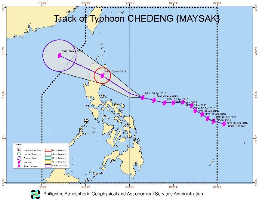
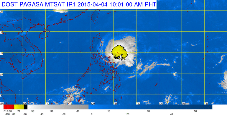
Typhoon "Maysak" forecast track on April 4, 2015 by PAGASA.
PAGASA alerted residents in low lying and mountainous areas of Isabela, Southern Cagayan, Kalinga, Mt. Province, Ifugao, Benguet, Nueva Viscaya, Quirino, Aurora and Catanduanes as well as the rest of Cagayan including Babuyan Island, Apayao, Ilocos Norte, Ilocos Sur, Abra, La Union, Pangasinan, Nueva Ecija, Tarlac, Pampanga, Bulacan, Rizal, Quezon, Camarines Norte and Camarines Sur against possible flashfloods and landslides.
Storm surges and sea surface waves of up to 2 meters are possible over the eastern coast of Aurora, Quezon and Isabela.
Fisherfolks are advised not to venture out over the northern seaboard of Northern Luzon and eastern seaboard of Bicol Region and of Visayas.
Typhoon "Maysak" on April 4, 2015. Image credit: NASA Terra/MODIS.
With the lowest recorded atmospheric pressure of 905 hPa (JMA, 18:45 UTC on March 31) Super Typhoon "Maysak" is the strongest western Pacific basin typhoon in recorded history prior to the month of April.
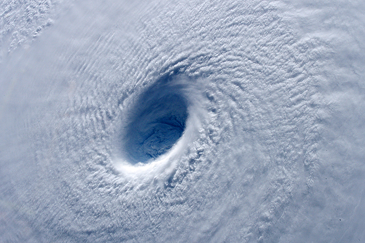
While Maysak was near peak intensity, astronauts on the International Space Station were treated to an awe-inspiring view of the storm. “Looking down into the eye – by far the widest one I’ve seen – it seemed like a black hole from a sci-fi movie,“ NASA astronaut Terry Virts tweeted.
What caught the astronauts’ attention was Maysak’s eye. Reported to be 30 kilometers (19 miles) wide by the JTWC, the eye had a near perfect ring of convection swirling around it. At the time, the storm appeared to be an annular tropical cyclone, a subcategory of storm known as a truck tire or doughnut storm. Annular storms are less prone to fluctuations in their intensity and tend to be persistent.
Typhoon "Maysak" as seen from ISS. Taken by ESA astronaut Samantha Cristoforetti on April 2, 2015.
The photograph of the eye also offers a good example of the stadium effect, a meteorological phenomenon defined by the eye being larger at the top of the storm than the bottom like the shape of a sports stadium. The effect happens because rising air in the eyewall tends to slope outward, while the air in the eye itself is descending. Cyclones typically form eyes when a storm’s winds exceed 125 km/h (78 mph). If an eye is growing smaller, it usually means the storm is strengthening.
The Visible Infrared Imaging Radiometer Suite (VIIRS) on the Suomi NPP satellite captured the nighttime image. When the Suomi NPP satellite passed over the storm at 16:42 UTC on April 2, 2015, the storm lacked an obvious eye, suggesting it was weakening. “It has lost definition since last night,” Virts noted in a tweet from the Space Station.
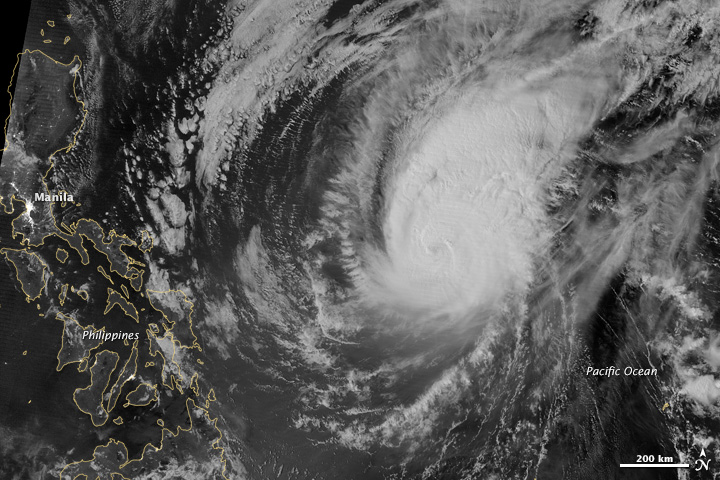
Image credit: Suomi NPP – VIIRS
Video courtesy of the WestPacWx
Satellite animations
- Storm-Centered Infrared (MTSAT2; NOAA/SSD)
- Storm-Centered Infrared (Aviation Color Enhancement) (MTSAT2; NOAA/SSD)
- Storm-Centered Water Vapor (MTSAT2; NOAA/SSD)
- Storm-Centered Visible (MTSAT2; NOAA/SSD)
- Storm-Centered Visible (Colorized) (MTSAT2; NOAA/SSD)
- Storm-Centered Infrared (MTSAT2; CIMSS)
- Storm-Centered Enhanced Infrared (MTSAT2; CIMSS)
- Storm-Centered Water Vapor (MTSAT2; CIMSS)
- Storm-Centered Visible (MTSAT2; CIMSS)
- South China Sea/West Pacific Infrared (MTSAT2; NOAA)
- South China Sea/West Pacific Enhanced Infrared (MTSAT2; NOAA)
- South China Sea/West Pacific Water Vapor (MTSAT2; NOAA)
I'm a dedicated researcher, journalist, and editor at The Watchers. With over 20 years of experience in the media industry, I specialize in hard science news, focusing on extreme weather, seismic and volcanic activity, space weather, and astronomy, including near-Earth objects and planetary defense strategies. You can reach me at teo /at/ watchers.news.
Commenting rules and guidelines
We value the thoughts and opinions of our readers and welcome healthy discussions on our website. In order to maintain a respectful and positive community, we ask that all commenters follow these rules.