
Super Typhoon “Hagupit” targets the Philippines
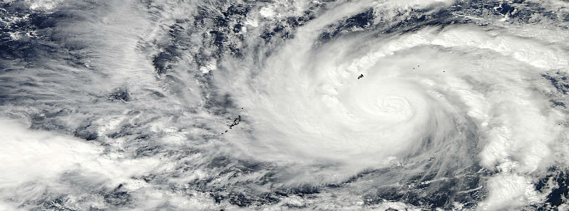
Featured image: NASA's Aqua/MODIS satellite captured a visible image of Typhoon Hagupit at 04:30 UTC on December 3, 2014 as it moved through Micronesia in the western Pacific Ocean. (Credit: LANCE Rapid Response/MODIS)
Hagupit reached Super Typhoon status with sustained winds near 240 km/h (150 mph) and gusts up to 300 km/h (185 mph) early on December 3, 2014. Super Typhoon Hagupit is crossing very warm ocean waters of 30°C (86°F) and with light wind shear conditions, it will gain more strength.
According to the Joint Typhoon Warning Center, Hagupit is expected to reach maximum sustained winds of 300 km/h (187 mph) with gusts up to 360 km/h (225 mph) early on December 6. Comparing to Haiyan, Hagupit has less ocean heat energy available. If Hagupit hits the Philippines, it will be a much weaker storm than Haiyan was but still very dangerous storm system.
.jpg)
850MB relative vorticity and IR satellite imagery taken on December 3, 2014. (Credit: NOAA/UW-CIMSS)
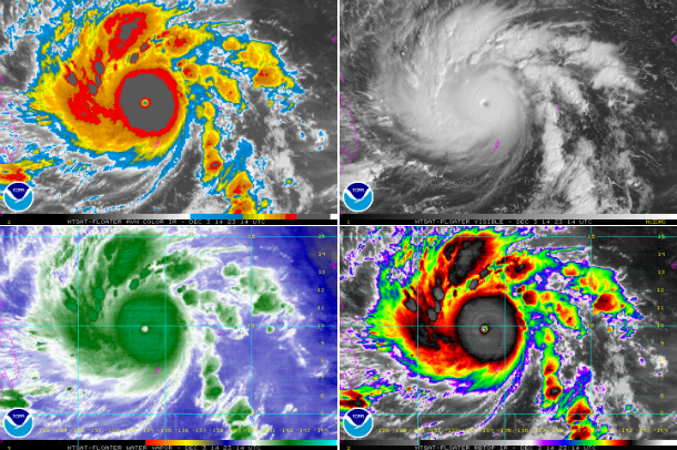
MTSAT satellite image composites taken at 23:14 UTC on December 3, 2014. (Credit: NOAA/MTSAT)
PAGASA registered central minimum pressure of 926 MB late on December 3. A high-pressure wall of air in the northern Pacific is preventing the typhoon from veering north. Hagupit is expected to enter the Philippine Area of Responsibility and will be given a local name "RUBY". As approaching the Philippines, Hagupit will have less heat energy available in the ocean, and wind shear is expected to rise, so the system is expected to weaken before possible landfall.
There is still much confusion on the future track of this dangerous storm. There are three scenarios. GFS forecasts the system to turn to the north and northeast, and then recurve as a much weaker system. NAVGEM forecast brings the storm in across southern Luzon, to track across the island and weaken.
ECMWF forecast model shows a landfall with maximum sustained winds of 170 km/h (106 mph) near 18 UTC on December 7, the southern Philippines near the Visayas-very close to Tacloban on Leyte Island, which was devastated by Super Typhoon Haiyan in November last year.
.png)
PAGASA and JTWC forecast tracks (Credit: PAGASA/JTWC)
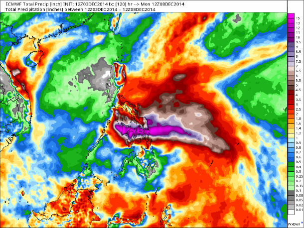
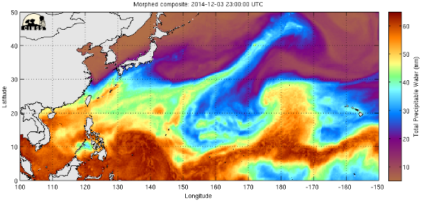
The ECMWF rainfall outlook shows a scenario that could lend to catastrophic flooding for low lying coastal communities around December 8, 2014. (Credit: ECMWF)
At this time, PAGASA expects Hagupit to enhance northeasterly winds over the seaboards of Northern Luzon and the eastern seaboard of Central Luzon resulting to rough to very rough sea conditions over the aforementioned areas. Fishers and those using small boats are advised not to venture out over the said seaboards.
Storm surges and exceptionally high tides are major issue aside from high wind, flooding rains and possible landslides in higher elevations.
Satellite animations
- Storm-Centered Infrared (MTSAT; NOAA/SSD)
- Storm-Centered Infrared (Aviation Color Enhancement) (MTSAT; NOAA/SSD)
- Storm-Centered Water Vapor (MTSAT; NOAA/SSD)
- Storm-Centered Visible (MTSAT; NOAA/SSD)
- Storm-Centered Visible (Colorized) (MTSAT; NOAA/SSD)
- Storm-Centered Infrared (MTSAT2; CIMSS)
- Storm-Centered Enhanced Infrared (MTSAT2; CIMSS)
- Storm-Centered Water Vapor (MTSAT2; CIMSS)
- Storm-Centered Visible (MTSAT2; CIMSS)
- Tropical West Pacific Infrared (MTSAT2; NOAA)
- Tropical West Pacific Enhanced Infrared (MTSAT2; NOAA)
- Tropical West Pacific Water Vapor (MTSAT2; NOAA)
- Tropical West Pacific Visible (MTSAT2; NOAA)
Commenting rules and guidelines
We value the thoughts and opinions of our readers and welcome healthy discussions on our website. In order to maintain a respectful and positive community, we ask that all commenters follow these rules.