
Large pyroclastic flows from Mount Sinabung disrupt flights, Indonesia
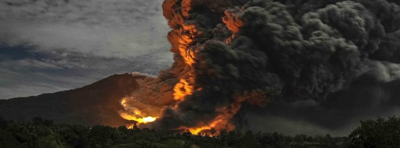
Featured image: Pyroclastic flows on Mount Sinabung - October 9, 2014. Image credit: Volcano Alert (@infoVolcano) via Twitter
Several large pyroclastic flows traveled down the southeast flank of Mount Sinabung on October 9, 2014, threatening the closest inhabited areas. Flights from the Kuala Namu International Airport in Deli Serdang regency, North Sumatra, to destinations in the province and Aceh are grounded due to thick volcanic ash.
Ash fall has occurred in more than 12 km distances as a result of the so-called co-ignimbrite ash plumes (rising ash from the avalanches) that rose to several km height.
The flows originated by collapses on the viscous growing lava lobe on the steep southeastern flank of the volcano and traveled distances of 3 – 4.5 km. Some still inhabited villages on the southern feet of the volcano are now at elevated risk, VolcanoDiscovery reported.
#Sinabung Oct 9, 2104; 10:16 pm Last night eruption taken from Ojolali Coffee stalls pic.twitter.com/Z0A1dBhpv0
— Volcano Alert (@infoVolcano) October 10, 2014
Susi Air Sumatra region coordinator Rosindah said the flight stoppage to all destinations in North Sumatra and Aceh was temporary. She was unaware how long the airline would not be serving these routes, however.
“We cannot promise when we will resume operations. If Mount Sinabung stops erupting, we will definitely fly,” Rosindah told The Jakarta Post and added all Susi Air’s routes in North Sumatra and Aceh were covered in volcanic ash.
The Karo regency administration stated that so far no casualties had been reported from the eruptions, which had been taking place from October 5.
#Sinabung from Jeraya 9 October 2014. by Sadrah Peranginangin. pic.twitter.com/HdHctZghVM
— Volcano Alert (@infoVolcano) October 11, 2014
Based on reports from PVMBG, BNPB reported four eruptions from Sinabung on October 5. The first one occurred at 01:46 local time and produced a pyroclastic flow that traveled 4.5 km S and an ash plume that rose 2 km.
The next three events, at 06:38, 07:36, and 07:53, all generated pyroclastic flows that traveled 2.5 – 4.5 km S. The fourth event also produced an ash plume that rose 3 km. A news article stated that pyroclastic flows from a fifth event at 09:00 were smaller, but again traveled 4.5 km after a sixth event at 12:00.
According to the Darwin VAAC a low-level eruption recorded by the PVMBG webcam generated a pyroclastic flow on October 6; some of the ash rose higher and drifted E. The Jakarta MWO noted that an ash plume rose to an altitude of 5.2 km (17 000 ft) a.s.l. and drifted S on October 7.
Geologic summary
Gunung Sinabung is a Pleistocene-to-Holocene stratovolcano with many lava flows on its flanks. The migration of summit vents along a N-S line gives the summit crater complex an elongated form. The youngest crater of this conical, 2460-m-high andesitic-to-dacitic volcano is at the southern end of the four overlapping summit craters.
An unconfirmed eruption was noted in 1881, and solfataric activity was seen at the summit and upper flanks of Sinabung in 1912.
No confirmed historical eruptions were recorded prior to explosive eruptions during August-September 2010 that produced ash plumes to 5 km above the summit. (GVP)
I'm a dedicated researcher, journalist, and editor at The Watchers. With over 20 years of experience in the media industry, I specialize in hard science news, focusing on extreme weather, seismic and volcanic activity, space weather, and astronomy, including near-Earth objects and planetary defense strategies. You can reach me at teo /at/ watchers.news.
Commenting rules and guidelines
We value the thoughts and opinions of our readers and welcome healthy discussions on our website. In order to maintain a respectful and positive community, we ask that all commenters follow these rules.