
One of the strongest storms recorded on the planet slams Philippines
Featured image: MTSAT color Infrared satellite image of Super Typhoon Haiyan over central Philippines taken at 08:57 UTC on November 8, 2013 (Credit: NOAA/MTSAT)
Powerful Super Typhoon Haiyan (Yolanda) made landfall in the province of Eastern Visayas, Philippines late on November 7, 2013. Widespread torrential rain and destructive winds accompanied Haiyan through the central Philippines, leaving a trail of destruction and triggering life-threatening flash floods and mudslides.
Sustained winds of 315 km/h (195 mph) were recorded at the time of landfall, which makes Haiyan the strongest tropical cyclone on record to make landfall. And with gusts as strong as 380 km/h (235 mph), Haiyan was probably the strongest tropical cyclone ever to hit land anywhere in the world in recorded history. The world's strongest recorded typhoon, cyclone or hurricane to make landfall was Hurricane Camille in 1969, which hit Mississippi with 305 km/h (190 mph) winds.
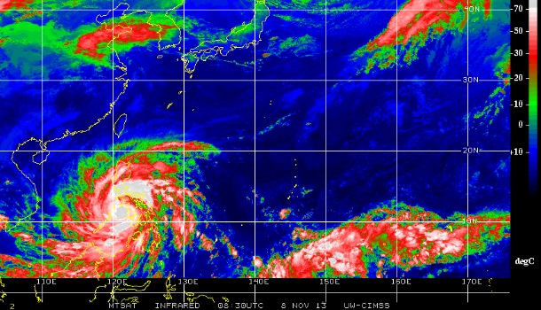
MTSAT Infrared satellite image taken at 08:30 UTC on November 08, 2013 (Credit: NOAA/MTSAT/CIMSS-UW)
.jpg)
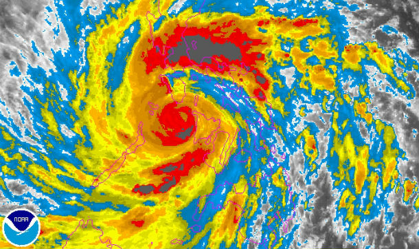
MTSAT color Infrared satellite image of Super Typhoon Haiyan over central Philippines taken at 08:57 UTC on November 8, 2013 (Credit: NOAA/MTSAT)
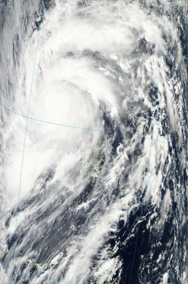
Aura/MODIS satellite image of the system taken at 05:05 UTC on November 8, 2013 (Credit: LANCE Rapid Response/MODIS)
More than 12 million people are at risk. About 125 000 people were moved to evacuation centers. The biggest concern is for residents of Bohol, island in the central Philippines that was struck by the powerful M 7.1 earthquake last month. Quake already displaced 350 000 people and many still experiencing its aftermath. Large number of families in this quake-hit area still live in makeshift tents and this is the hardest time for them. Now they have the strongest storm ever to fight with. Our prayer goes out to them.
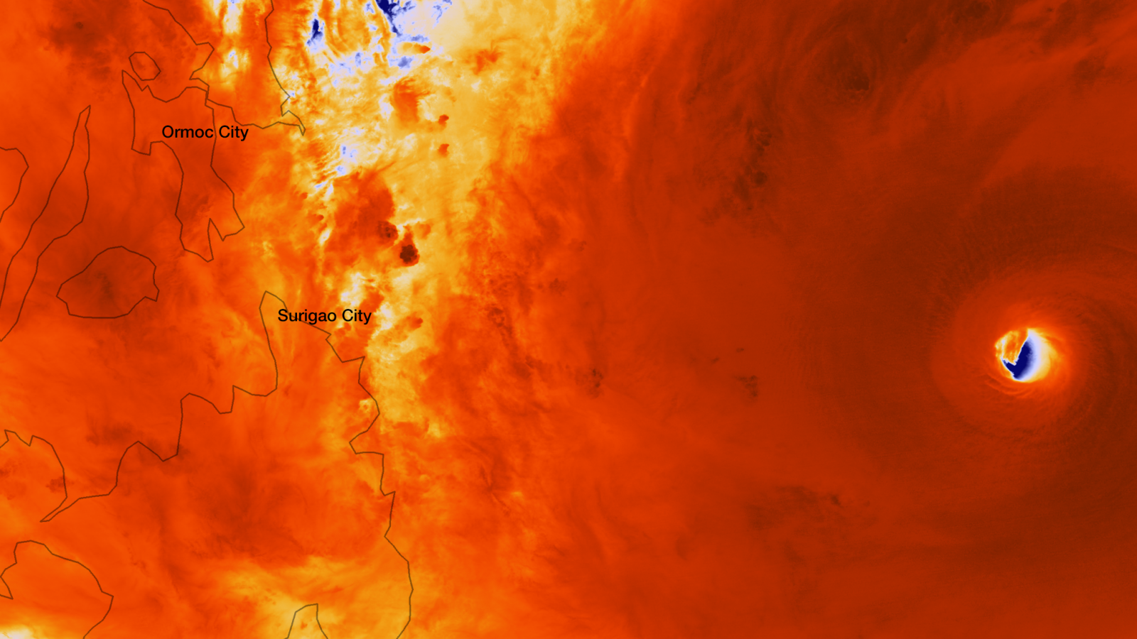
The Suomi NPP satellite captured an incredibly detailed infrared image of Super Typhoon Haiyan's eye as it orbited over the storm at approximately 05:25 UTC on November 7, 2013. (Credit: NOAA/SUOMI NPP)
The storm is expected to weaken slightly as it moves across land, but forecasters predict that it will maintain super typhoon intensity throughout its passage over the islands. After passing through the Philippines, Haiyan is expected to move through the South China Sea as it heads for landfall in Vietnam.
According to latest report by Joint Typhoon Warning Center (JTWC), at 09:00 UTC the center of STY Haiyan was located approximately 214 nm south-southeast of Manila, Philippines, and was moving westward at speed of 22 knots (41 km/h, 26 mph). Maximum sustained winds were 145 knots (268 km/h, 166 mph) with gusts up to 175 knots (324 km/h, 201 mph).
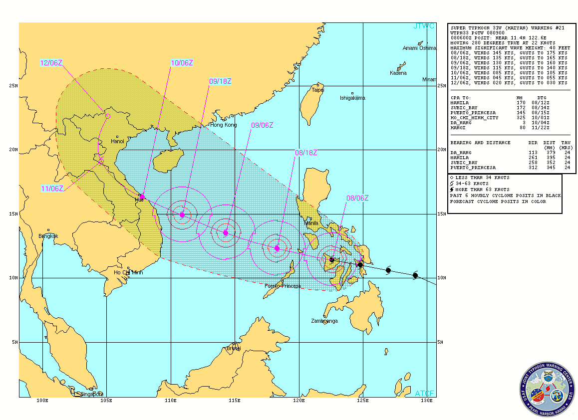
Super Typhoon Haiyan forecast track (Source: JTWC)
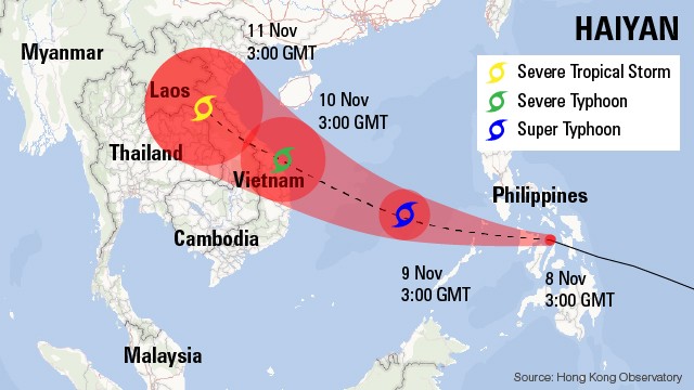
Forecast track by Hong Kong Observatory
At its peak, the winds of Haiyan were equivalent to peak winds of Typhoon Tip, which was known for having the lowest sea-level pressure ever observed on Earth and its massive size. Haiyan's tropical-storm-force winds are extending 240 kilometers from the typhoon's center.
Haiyan is the 24th named storm to hit the Philippines this year. An average of 20 typhoons hit the Philippines every year.
Satellite Animations
- Storm-Centered Infrared (MTSAT; NOAA/SSD)
- Storm-Centered Infrared (Aviation Color Enhancement) (MTSAT; NOAA/SSD)
- Storm-Centered Water Vapor (MTSAT; NOAA/SSD)
- Storm-Centered Visible (MTSAT; NOAA/SSD)
- Storm-Centered Visible (Colorized) (MTSAT; NOAA/SSD)
- South China Sea/West Pacific Infrared (MTSAT2; NOAA)
- South China Sea/West Pacific Enhanced Infrared (MTSAT2; NOAA)
- South China Sea/West Pacific Water Vapor (MTSAT2; NOAA)
.jpg)
The fact is this storm ramped up in a predicted solar driven Top red R5 period and without that it would have been just another typhoon. Or, do the Warmist cherry-Pickers think C02 caused those solar events? Furthermore we warned there would be more very extreme storms in the developing Mia wild jet stream conditions even if less storms in number. This is being confirmed. The biggest storm in the last 400 years in Europe was the tempest of 1703 which came in the later part of the Maunder Minimum Mini ice age. The warmists cannot predict anything and are holding back science. Their sect must be destroyed, or as Scipio would have said "Dalenda est warmistas".