
Active volcanoes in the world – March 27 – April 2, 2013
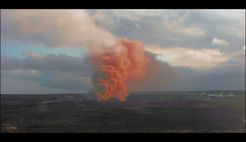
Image credit: TW
This week, 8 volcanoes were noticed to have new activity, whereas ongoing activity was reported for 12 volcanoes. This report covers active volcanoes in the world recorded from March 27 – April 2, 2013 based on Smithsonian/USGS criteria.
New activity/unrest: | Copahue, Central Chile-Argentina border | Dieng Volcanic Complex, Central Java (Indonesia) | Fuego, Guatemala | Grozny Group, Iturup Island | Hekla, Southern Iceland | Hierro, Canary Islands (Spain) | Sabancaya, Perú | Tungurahua, Ecuador
Ongoing activity: | Batu Tara, Komba Island (Indonesia) | Kilauea, Hawaii (USA) | Kizimen, Eastern Kamchatka (Russia) | Paluweh, Lesser Sunda Islands (Indonesia) | Popocatépetl, México | Sakura-jima, Kyushu | Santa María, Guatemala | Shiveluch, Central Kamchatka (Russia) | Soufrière Hills, Montserrat | Tolbachik, Central Kamchatka (Russia) | Tongariro, North Island (New Zealand) | White Island, New Zealand
The Weekly Volcanic Activity Report is a cooperative project between the Smithsonian’s Global Volcanism Program and the US Geological Survey’s Volcano Hazards Program. Updated by 2300 UTC every Wednesday, notices of volcanic activity posted on these pages are preliminary and subject to change as events are studied in more detail. This is not a comprehensive list of all of Earth’s volcanoes erupting during the week, but rather a summary of activity at volcanoes that meet criteria discussed in detail in the “Criteria and Disclaimers” section. Carefully reviewed, detailed reports on various volcanoes are published monthly in the Bulletin of the Global Volcanism Network.
New activity/unrest
COPAHUE, Central Chile-Argentina border
37.85°S, 71.17°W; summit elev. 2997 m
Based on analysis of satellite imagery and a pilot observation, the Buenos Aires VAAC reported that on 28 March steam-and-gas emissions with small amounts of ash rose from Copahue.
Geologic summary: Volcán Copahue is an elongated composite cone constructed along the Chile-Argentina border within the 6.5 x 8.5 km wide Trapa-Trapa caldera that formed between 0.6 and 0.4 million years ago near the NW margin of the 20 x 15 km Pliocene Caviahue (Del Agrio) caldera. The eastern summit crater, part of a 2-km-long, ENE-WSW line of nine craters, contains a briny, acidic 300-m-wide crater lake (also referred to as El Agrio or Del Agrio) and displays intense fumarolic activity. Acidic hot springs occur below the eastern outlet of the crater lake, contributing to the acidity of the Río Agrio, and another geothermal zone is located within Caviahue caldera about 7 km NE of the summit. Infrequent mild-to-moderate explosive eruptions have been recorded at Copahue since the 18th century. Twentieth-century eruptions from the crater lake have ejected pyroclastic rocks and chilled liquid sulfur fragments.
DIENG VOLCANIC COMPLEX, Central Java (Indonesia)
7.20°S, 109.92°E; summit elev. 2565 m
CVGHM reported that during 10-26 March gas emissions continued to be elevated at Timbang, a cone that is part of the Dieng Volcanic Complex. Plumes containing carbon dioxide and hydrogen sulfide drifted 2 km, and were toxic at a distance of 550 m. Seismicity increased during 13-26 March and then significantly increased on 27 March. CVGHM raised the Alert Level to 3 (on a scale of 1-4) on 27 March and warned the public not to approach Timbang Crater within a 1 km radius.
Geologic summary: The Dieng plateau in the highlands of central Java is renowned both for the variety of its volcanic scenery and as a sacred area housing Java’s oldest Hindu temples, dating back to the 9th century AD. The Dieng volcanic complex consists of two or more stratovolcanoes and more than 20 small craters and cones of Pleistocene-to-Holocene age over a 6 x 14 km area. Prahu stratovolcano was truncated by a large Pleistocenecaldera, which was subsequently filled by a series of dissected to youthful cones, lava domes, and craters, many containing lakes. Lava flows cover much of the plateau, but have not occurred in historical time, when activity has been restricted to minor phreatic eruptions. Toxic volcanic gas emission has caused fatalities and is a hazard at several craters. The abundant thermal features that dot the plateau and high heat flow make Dieng a major geothermal prospect.
FUEGO, Guatemala
14.473°N, 90.880°W; summit elev. 3763 m
INSIVUMEH reported that during 27 March-2 April explosions from Fuego generated rumbling noises, occasional shock waves, and ash plumes that rose 0.6-1.3 km above the crater and drifted 8-15 km W, SW, and S. Incandescent material was ejected 100-200 m above the crater. Ashfall was reported in Panimaché I and II (8 km SW), Morelia (9 km SW), and Hagia Sophia. Block avalanches descended the flanks and during 1-2 April reached vegetated areas.
Geologic summary: Volcán Fuego, one of Central America’s most active volcanoes, is one of three largestratovolcanoes overlooking Guatemala’s former capital, Antigua. The scarp of an older edifice, Meseta, lies between 3,763-m-high Fuego and its twin volcano to the N, Acatenango. Construction of Meseta volcano continued until the late Pleistocene or early Holocene, after which growth of the modern Fuego volcano continued the southward migration of volcanism that began at Acatenango. Frequent vigorous historical eruptions have been recorded at Fuego since the onset of the Spanish era in 1524, and have produced major ashfalls, along with occasional pyroclastic flows and lava flows. The last major explosive eruption from Fuego took place in 1974, producing spectacular pyroclastic flows visible from Antigua.
GROZNY GROUP, Iturup Island
45.026°N, 147.922°E; summit elev. 1211 m
Based on analysis of satellite images, the Tokyo VAAC reported that on 30 March a possible eruption from Grozny Group may have produced a plume that rose 2.1 km (7,000 ft) a.s.l. and drifted E. A later VAAC notice stated thatash had dissipated.
Geologic summary: The Grozny volcano group in central Iturup Island contains the complex volcanoes of Ivan Grozny and Tebenkov. The former has a 3-3.5 km diameter caldera that is open to the south, where the large, 1158-m-high andesitic Grozny extrusion dome (also known as Etorofu-Yake-yama) was emplaced. Several other lava domes of Holocene age were constructed to the NE; extrusion of these domes has constricted a former lake in the northern side of the caldera to an extremely sinuous shoreline. The forested andesitic Tebenkov volcano, also known as Odamoi-san, lies immediately to the NE of the Grozny dome complex. The large Machekh crater, which displays strong fumarolic activity, lies immediately south of Tebenkov. Historical eruptions, the first of which took place in 1968, have been restricted to Ivan Grozny.
HEKLA, Southern Iceland
63.98°N, 19.70°W; summit elev. 1491 m
On 29 March the Icelandic Meteorological Office noted that Hekla had been quiet the previous few days; no additional earthquakes had been detected since a period of increased seismicity during 10-26 March. The Icelandic Civil Defense continued to maintain a level of “uncertainty”.
Geologic summary: One of Iceland’s most prominent and active volcanoes, Hekla lies near the southern end of the eastern rift zone. Hekla occupies a rift-transform junction, and has produced basaltic andesites, in contrast to the tholeiitic basalts typical of Icelandic rift zone volcanoes. Vatnafjöll, a 40-km-long, 9-km-wide group of basaltic fissures and crater rows immediately SE of Hekla forms a part of the Hekla-Vatnafjöll volcanic system. A 5.5-km-long fissure, Heklugjá, cuts across the 1491-m-high Hekla volcano and is often active along its full length during major eruptions. Repeated eruptions along this rift, which is oblique to most rifting structures in the eastern volcanic zone, are responsible for Hekla’s elongated ENE-WSW profile. Frequent large silicic explosive eruptions duringhistorical time have deposited tephra throughout Iceland, providing valuable time markers used to date eruptions from other Icelandic volcanoes. Hekla tephras are generally rich in fluorine and are consequently very hazardous to grazing animals. Extensive lava flows from Hekla’s historical eruptions, which date back to 1104 AD, cover much of the volcano’s flanks.
HIERRO, Canary Islands (Spain)
27.73°N, 18.03°W; summit elev. 1500 m
On 18 March seismic activity at El Hierro sharply increased. Earthquakes were initially located around the NW tip of the island, at about 20 km depth, then later migrated W about 12-15 km offshore W of El Hierro Island, at similar depth. About 100 earthquakes of Mb 3.5 (body wave measurement) or greater had been located, many of them felt by residents. The biggest events occurred on 29 March (Mb 4.7) and 31 March (Mw 4.6, moment magnitude) both at 20 km depth. IGN’s GPS data showed inflation of the island, with maximum deformation at the westernmost station of about 10 cm in the horizontal component and about 11 cm in the vertical. Deformation rates reached a maximum during 23-24 March. An increase in carbon dioxide flux was observed in the W area.
Rockfalls were reported on the steep slopes, especially during 26-29 March. On the evening of 27 March the Plan de Protección Civil por Riesgo Volcánico (PEVOLCA) raised the Volcanic Alert Code for the population to Yellow, and closed the access to the W part of the island.
Geologic summary: The triangular island of Hierro is the SW-most and least studied of the Canary Islands. The massive Hierro shield volcano is truncated by a large NW-facing escarpment formed as a result of gravitational collapse of El Golfo volcano about 130,000 years ago. The steep-sided 1500-m-high scarp towers above a low lavaplatform bordering 12-km-wide El Golfo Bay, and three other large submarine landslide deposits occur to the SW and SE. Three prominent rifts oriented NW, NE, and south at 120 degree angles form prominent topographic ridges. The subaerial portion of the volcano consists of flat-lying Quaternary basaltic and trachybasaltic lava flows and tuffs capped by numerous young cinder cones and lava flows. Holocene cones and flows are found both on the outer flanks and in the El Golfo depression. Hierro contains the greatest concentration of young vents in the Canary Islands. Uncertainty surrounds the report of an historical eruption in 1793.
SABANCAYA, Perú
15.78°S, 71.85°W; summit elev. 5967 m
In an Instituto Geofísico de Perú (IGP) report, a photo showed a fumarolic plume rising above Sabancaya on 8 March. During the third week of March, a bluish colored plume rose 500 m above the crater, possibly indicating sulfur dioxide emissions. On 25 March the seismic network detected a continuing high rate of volcano-tectonic (VT) earthquakes and an increasing number of long-period (LP) events. On 27 March and 1 April VT earthquakes continued to be dominant and located below the NE sector of the crater. The number and amplitude of LP events did not change.
Previously, residents of Sallalli, 11 km S of Sabancaya, reported that fumarolic activity had increased on 5 December 2012. Four earthquakes within 15 km of the crater during 22-23 February caused damage in Maca, 20 km NE. In response, the Instituto Geofísico de Perú (IGP) installed seismic stations and recorded hundreds of earthquakes per day.
INGEMMET also installed monitoring equipment, and in partnership with IGP increased monitoring efforts. On 27 February scientists observed that the emissions were mostly water vapor, carbon dioxide, and sulfur dioxide. During 28 February-5 March there were 400-500 earthquakes per day recorded, mostly volcano-tectonic events.
Geologic summary: Sabancaya, located on the saddle between 6288-m-high Ampato and 6025-m-high Hualca Hualca volcanoes, is the youngest of these volcanic centers and the only one to have erupted in historical time. The oldest of the three volcanoes, Nevado Hualca Hualca, is of probable late-Pliocene to early Pleistocene age. Both Nevado Ampato and Nevado Sabancaya are only slightly affected by glacial erosion and consist of a series of lava domes aligned along a NW-SW trend. The name of 5967-m-high Sabancaya (meaning “tongue of fire” in the Quechua Indian language) first appeared in records in 1595 AD, suggesting activity prior to that date. Holoceneactivity has consisted of plinian eruptions followed by emission of voluminous andesitic and dacitic lava flows, which form an extensive apron around the volcano on all sides but the south. Records of historical eruptions of Sabancaya date back to 1750.
TUNGURAHUA, Ecuador
1.467°S, 78.442°W; summit elev. 5023 m
IG reported that during 27 March-2 April seismicity at Tungurahua continued to trend downward, remaining at moderate levels. Cloud cover often prevented observations; a weak steam plume was observed rising from the crater on 27 March.
Geologic summary: The steep-sided Tungurahua stratovolcano towers more than 3 km above its northern base. It sits ~140 km S of Quito, Ecuador’s capital city, and is one of Ecuador’s most active volcanoes. Historical eruptions have all originated from the summit crater. They have been accompanied by strong explosions and sometimes bypyroclastic flows and lava flows that reached populated areas at the volcano’s base. The last major eruption took place from 1916 to 1918, although minor activity continued until 1925. The latest eruption began in October 1999 and prompted temporary evacuation of the town of Baños on the N side of the volcano.
Ongoing activity
BATU TARA, Komba Island (Indonesia)
7.792°S, 123.579°E; summit elev. 748 m
Based on analyses of satellite imagery and wind data, the Darwin Volcanic Ash Advisory Centre (VAAC) reported that during 30 March-1 April ash plumes from Batu Tara rose to altitudes of 2.4-3 km (8,000-10,000 ft) a.s.l. and drifted 55-75 km NE.
Geologic summary: The small isolated island of Batu Tara in the Flores Sea about 50 km north of Lembata (formerly Lomblen) Island contains a scarp on the eastern side similar to the Sciara del Fuoco of Italy’s Stromboli volcano. Vegetation covers the flanks of Batu Tara to within 50 m of the 748-m-high summit. Batu Tara lies north of the main volcanic arc and is noted for its potassic leucite-bearing basanitic and tephritic rocks. The first historicaleruption from Batu Tara, during 1847-52, produced explosions and a lava flow.
KILAUEA, Hawaii (USA)
19.421°N, 155.287°W; summit elev. 1222 m
During 27 March-2 April HVO reported that the circulating lava lake periodically rose and fell in the deep pit within Kilauea’s Halema’uma’u Crater. The plume from the vent continued to deposit variable amounts of ash, spatter, andPele’s hair onto nearby areas.
At Pu’u ‘O’o Crater, glow emanated from four spatter cones on the crater floor. Two lava flows (Peace Day and Kahauale’a) were fed by lava tubes extending from Pu’u ‘O’o. Multiple lava flows from the NE spatter cone, collectively called the Kahauale’a flow, traveled across the NE flank of Pu’u ‘O’o cone to the cone’s base and advanced more than 4.4 km NE over older flows. A branch also traveled S, just S of Pu’u Kahauale’a. Peace Day activity consisted of lava flows active above the pali (5 km SE of Pu’u ‘O’o), on the pali, and on the coastal plain.Lava also entered the ocean at two main locations spanning the National Park boundary.
Geologic summary: Kilauea, one of five coalescing volcanoes that comprise the island of Hawaii, is one of the world’s most active volcanoes. Eruptions at Kilauea originate primarily from the summit caldera or along one of the lengthy E and SW rift zones that extend from the caldera to the sea. About 90% of the surface of Kilauea is formed of lava flows less than about 1,100 years old; 70% of the volcano’s surface is younger than 600 years. A long-term eruption from the East rift zone that began in 1983 has produced lava flows covering more than 100 sq km, destroying nearly 200 houses and adding new coastline to the island.
KIZIMEN, Eastern Kamchatka (Russia)
55.130°N, 160.32°E; summit elev. 2376 m
KVERT reported that during 22-29 March moderate seismic activity continued at Kizimen. Video and satellite data showed that lava continued to extrude from the summit, producing incandescence, strong gas-and-steam activity, and hot avalanches on the W and E flanks. Satellite images detected a daily thermal anomaly over the volcano. TheAviation Color Code remained at Orange.
Geologic summary: Kizimen is an isolated, conical stratovolcano that is morphologically similar to Mount St. Helens prior to its 1980 eruption. The summit of Kizimen consists of overlapping lava domes, and blocky lava flows descend the flanks of the volcano, which is the westernmost of a volcanic chain north of Kronotsky volcano. The 2,376-m-high Kizimen was formed during four eruptive cycles beginning about 12,000 years ago and lasting 2,000-3,500 years. The largest eruptions took place about 10,000 and 8300-8400 years ago, and three periods of longterm lava-dome growth have occurred. The latest eruptive cycle began about 3,000 years ago with a large explosion and was followed by lava-dome growth lasting intermittently about 1,000 years. An explosive eruption about 1,100 years ago produced a lateral blast and created a 1.0 x 0.7 km wide crater breached to the NE, inside which a small lava dome (the fourth at Kizimen) has grown. A single explosive eruption, during 1927-28, has been recorded in historical time.
PALUWEH, Lesser Sunda Islands (Indonesia)
8.32°S, 121.708°E; summit elev. 875 m
Based on analyses of satellite imagery and wind data, the Darwin VAAC reported that during 27 March-1 April ashplumes from Paluweh rose to altitudes of 2.4-3.7 km (8,000-12,000 ft) a.s.l. and drifted 45-100 km N, NE, and E.
Geologic summary: Paluweh volcano, also known as Rokatenda, forms the 8-km-wide island of Paluweh N of the volcanic arc that cuts across Flores Island. Although the volcano rises about 3,000 m above the sea floor, its summit reaches only 875 m above sea level. The broad irregular summit region contains overlapping craters up to 900 m wide and several lava domes. Several flank vents occur along a NW-trending fissure. The largest historical eruption of Paluweh occurred in 1928, when a strong explosive eruption was accompanied by landslide-induced tsunamis and lava-dome emplacement.
POPOCATEPETL, México
19.023°N, 98.622°W; summit elev. 5426 m
CENAPRED reported that during 26 March-1 April seismicity at Popocatépetl indicated continuing gas-and-steam emissions that contained ash. Although views of the volcano were often obscured by cloud cover, gas-and-ash plumes were observed daily. Incandescence from the crater was observed at night and sometimes increased in conjunction with emissions. On 26 March incandescent fragments ejected as far as 1 km from the crater landed on the NNE flanks. An explosion produced an ash plume that rose 1.5 km above the crater. On 29 March incandescent fragments ejected 700 m from the crater landed on the N and NE flanks. On 31 March ash emissions were observed continuously for about an hour. Ash plumes rose over 2 km and drifted E. The Alert Level remained at Yellow, Phase Two.
Geologic summary: Popocatépetl, whose name is the Aztec word for smoking mountain, towers to 5,426 m 70 km SE of Mexico City and is North America’s second-highest volcano. Frequent historical eruptions have been recorded since the beginning of the Spanish colonial era. A small eruption on 21 December 1994 ended five decades of quiescence. Since 1996 small lava domes have incrementally been constructed within the summit crater and destroyed by explosive eruptions. Intermittent small-to-moderate gas-and-ash eruptions have continued, occasionally producing ashfall in neighboring towns and villages.
SAKURA-JIMA, Kyushu
31.585°N, 130.657°E; summit elev. 1117 m
Based on information from JMA, the Tokyo VAAC reported that explosions from Sakura-jima during 28 March-1 April generated plumes that rose to altitudes of 1.8-2.7 km (6,000-9,000 ft) a.s.l. and drifted NE, E, and SE. JMA reported that during 29 March-1 April four explosions from Showa Crater ejected tephra at most 1.3 km from the crater.
Geologic summary: Sakura-jima, one of Japan’s most active volcanoes, is a post-caldera cone of the Aira calderaat the northern half of Kagoshima Bay. Eruption of the voluminous Ito pyroclastic flow was associated with the formation of the 17 x 23-km-wide Aira caldera about 22,000 years ago. The construction of Sakura-jima began about 13,000 years ago and built an island that was finally joined to the Osumi Peninsula during the major explosive and effusive eruption of 1914. Activity at the Kita-dake summit cone ended about 4,850 years ago, after which eruptions took place at Minami-dake. Frequent historical eruptions, recorded since the 8th century, have depositedash on Kagoshima, one of Kyushu’s largest cities, located across Kagoshima Bay only 8 km from the summit. The largest historical eruption took place during 1471-76.
SANTA MARIA, Guatemala
14.756°N, 91.552°W; summit elev. 3772 m
INSIVUMEH reported that during 27-29 March explosions from Santa María’s Santiaguito lava-dome complex produced ash plumes that rose 800 m and drifted SW. During 29-30 March ashfall was reported in El Faro (SW flank) and La Florida (5 km S). An explosion during 1-2 April generated ash plumes that rose 500 m and drifted SE, causing ashfall in San José. Avalanches were generated by active lava flows during 29 March-2 April.
Geologic summary: Symmetrical, forest-covered Santa María volcano is one of a chain of large stratovolcanoesthat rises dramatically above the Pacific coastal plain of Guatemala. The stratovolcano has a sharp-topped, conical profile that is cut on the SW flank by a large, 1-km-wide crater, which formed during a catastrophic eruption in 1902 and extends from just below the summit to the lower flank. The renowned Plinian eruption of 1902 followed a long repose period and devastated much of SW Guatemala. The large dacitic Santiaguito lava-dome complex has been growing at the base of the 1902 crater since 1922. Compound dome growth at Santiaguito has occurred episodically from four westward-younging vents, accompanied by almost continuous minor explosions and periodiclava extrusion, larger explosions, pyroclastic flows, and lahars.
SHIVELUCH, Central Kamchatka (Russia)
56.653°N, 161.360°E; summit elev. 3283 m
Based on visual observations and analyses of satellite data, KVERT reported that during 22-29 March a viscouslava flow effused on the E flank of Shiveluch’s lava dome, accompanied by hot avalanches, incandescence, andfumarolic activity. Satellite imagery showed a daily thermal anomaly on the lava dome. The Aviation Color Coderemained at Orange.
Geologic summary: The high, isolated massif of Shiveluch volcano (also spelled Sheveluch) rises above the lowlands NNE of the Kliuchevskaya volcano group and forms one of Kamchatka’s largest and most active volcanoes. The currently active Molodoy Shiveluch lava-dome complex was constructed during the Holocene within a large breached caldera formed by collapse of the massive late-Pleistocene Strary Shiveluch volcano. At least 60 large eruptions of Shiveluch have occurred during the Holocene, making it the most vigorous andesitic volcano of the Kuril-Kamchatka arc. Frequent collapses of lava-dome complexes, most recently in 1964, have produced large debris avalanches whose deposits cover much of the floor of the breached caldera. Intermittent explosive eruptions began in the 1990s from a new lava dome that began growing in 1980. The largest historical eruptions from Shiveluch occurred in 1854 and 1964.
SOUFRIERE HILLS, Montserrat
16.72°N, 62.18°W; summit elev. 915 m
MVO reported that during 22-29 March activity at the Soufrière Hills lava dome was at a low level. A pyroclastic flowtraveled down the Tar River Valley (E) at about 0500 on 28 March. The flow was not observed directly, but the deposits indicated that it traveled halfway down the valley, 1-1.5 km from the dome. There were no reports of ashfall; any ash was probably blown over Plymouth and out to sea. The source of the flow was not known due to cloud cover, but was likely from the failure a large slab that had been slowing moving away from the dome. Heavy rainfall during the evening of 28 March generated large lahars in several valleys around the volcano, including in the Belham Valley (NW). These started at about 1900 and lasted for several hours. The Hazard Level remained at 2 (on a scale of 1-5).
Geologic summary: The complex dominantly andesitic Soufrière Hills volcano occupies the southern half of the island of Montserrat. The summit area consists primarily of a series of lava domes emplaced along an ESE-trending zone. English’s Crater, a 1-km-wide crater breached widely to the E, was formed during an eruption about 4,000 years ago in which the summit collapsed, producing a large submarine debris avalanche. Block-and-ash flow and surge deposits associated with dome growth predominate in flank deposits at Soufrière Hills. Non-eruptive seismic swarms occurred at 30-year intervals in the 20th century, but with the exception of a 17th-century eruption that produced the Castle Peak lava dome, no historical eruptions were recorded on Montserrat until 1995. Long-term small-to-moderate ash eruptions beginning in that year were later accompanied by lava-dome growth andpyroclastic flows that forced evacuation of the southern half of the island and ultimately destroyed the capital city of Plymouth, causing major social and economic disruption.
TOLBACHIK, Central Kamchatka (Russia)
55.830°N, 160.330°E; summit elev. 3682 m
KVERT reported that the S fissure along the W side of Tolbachinsky Dol, a lava plateau on the SW side of Tolbachik, continued to produce very fluid lava flows during 22-29 March that traveled to the W, S, and E sides of the plateau. Cinder cones continued to grow along the fissure. Gas-and-ash plumes rose to an altitude of 3.5 km (11,500 ft) a.s.l. and drifted in multiple directions. A very large thermal anomaly on the N part of Tolbachinsky Dol was visible daily in satellite imagery. The Aviation Color Code remained at Orange.
Geologic summary: The massive Tolbachik basaltic volcano is located at the southern end of the dominantlyandesitic Kliuchevskaya volcano group. The Tolbachik massif is composed of two overlapping, but morphologically dissimilar volcanoes. The flat-topped Plosky Tolbachik shield volcano with its nested Holocene Hawaiian-typecalderas up to 3 km in diameter is located east of the older and higher sharp-topped Ostry Tolbachik stratovolcano. The summit caldera at Plosky Tolbachik was formed in association with major lava effusion about 6500 years ago and simultaneously with a major southward-directed sector collapse of Ostry Tolbachik volcano. Lengthy rift zones extending NE and SSW of the volcano have erupted voluminous basaltic lava flows during the Holocene, with activity during the past two thousand years being confined to the narrow axial zone of the rifts. The 1975-76 eruption originating from the SSW-flank fissure system and the summit was the largest historical basaltic eruption in Kamchatka.
TONGARIRO, North Island (New Zealand)
39.13°S, 175.642°E; summit elev. 1978 m
On 25 March GeoNet reported that Tongariro remained quiet with no eruptive activity being detected since the explosion on 21 November 2012. Steam-and-gas plumes rose from the Te Maari Craters. The Aviation Colour Code was lowered to Green (second lowest on a 4 four-color scale) and the Volcanic Alert Level remained at 1 (on a scale of 0-5).
Geologic summary: Tongariro is a large andesitic volcanic massif, located immediately NE of Ruapehu volcano, that is composed of more than a dozen composite cones constructed over a period of 275,000 years. Vents along a NE-trending zone extending from Saddle Cone (below Ruapehu volcano) to Te Mari crater (including vents at the present-day location of Ngauruhoe) were active during a several hundred year long period around 10,000 years ago, producing the largest known eruptions at the Tongariro complex during the Holocene. The youngest cone of the complex, Ngauruhoe, has grown to become the highest peak of the massif since its birth about 2500 years ago. The symmetrical, steep-sided Ngauruhoe, along with its neighbor Ruapehu to the south, have been New Zealand’s most active volcanoes during historical time.
WHITE ISLAND, New Zealand
37.52°S, 177.18°E; summit elev. 321 m
On 26 March GeoNet Data Centre reported that a pattern of repeating minor activity at White Island had become established over the last month. Periods of passive steaming and degassing were accompanied by very low levels of volcanic tremor. This activity alternated with minor mud-and-steam explosions from the active crater when there was strong volcanic tremor. Sulfur dioxide gas measurements on 20 March were at similar levels to the past month, although carbon dioxide levels were higher. The Aviation Colour Code remained at Yellow and the Volcanic Alert Level remained at 1 (on a scale of 0-5).
Geologic summary: The uninhabited 2 x 2.4 km White Island, one of New Zealand’s most active volcanoes, is the emergent summit of a 16 x 18 km submarine volcano in the Bay of Plenty about 50 km offshore of North Island. The 321-m-high island consists of two overlapping stratovolcanoes; the summit crater appears to be breached to the SE because the shoreline corresponds to the level of several notches in the SE crater wall. Throughout the shorthistorical period beginning in 1826 the volcano has had long periods of continuous hydrothermal activity and steam release, punctuated by small-to-medium eruptions. Its activity also forms a prominent part of Maori legends. The most recent eruptive episode, which began on 7 March 2000, included the largest eruption at White Island in the past 20 years on 27 July.
Source: Global Volcanism Program
Featured image by: Alan L
Commenting rules and guidelines
We value the thoughts and opinions of our readers and welcome healthy discussions on our website. In order to maintain a respectful and positive community, we ask that all commenters follow these rules.