
Active volcanoes in the world: July 11 – July 17, 2012
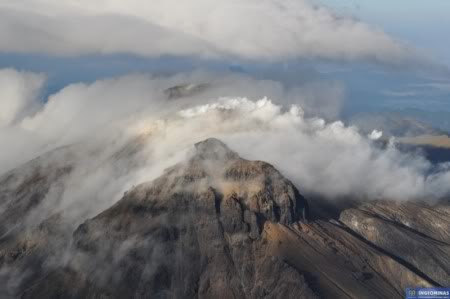
Image credit: INGEOMINAS
New unrest has been noticed around 3 volcanoes, ongoing activity was reported for 12 volcanoes. This report covers active volcanoes in the world recorded from July 11 – July 17, 2012 based on Smithsonian/USGS criteria.
CUMBAL
Colombia 0.95°N, 77.87°W; summit elev. 4764 m
According to INGEOMINAS, a 10 July report from the Observatorio de Pasto noted that during recent months seismic swarms at Cumbal had been detected. Steam plumes from fumarolic fields were common. Nearby residents reported increases in gas emissions and seismicity, as well as possible noises. The Alert Level was increased to III (Yellow; “changes in the behavior of volcanic activity”).
Geologic summary: Many youthful lava flows extend from the glacier-capped Cumbal volcano, the southernmost historically active volcano of Colombia. The volcano is elongated in a NE-SW direction and is composed primarily of andesitic-dacitic lava flows. Two fumarolically active craters occupy the summit ridge; the main crater on the NE side and Mundo Nuevo crater on the SW side. A young lava dome occupies the 250-m-wide summit crater, and eruptions from the upper east flank produced a 6-km-long lava field. The oldest crater lies NNE of the summit crater, suggesting SW-ward migration of activity. Explosive eruptions in 1877 and 1926 are the only known historicalactivity from Cumbal. Fumarole fields are found in the two summit craters, and thermal springs are located on the SE flanks.
HIERRO
Canary Islands (Spain) 27.73°N, 18.03°W; summit elev. 1500 m
Instituto Geográfico Nacional (IGN) reported that during 11-17 July both seismic activity and deformation at El Hierro decreased. There were 87 seismic events located, most of them offshore SW of El Hierro Island at about 20 km depth. Only six earthquakes were M 2.7 or higher, and the maximum magnitude recorded was 3.4, corresponding to two events: 14 July at 1952 and 17 July at 0746. The deformation rate decreased, with maximum values of less than 1 cm in the horizontal components.
Geologic summary: The triangular island of Hierro is the SW-most and least studied of the Canary Islands. The massive Hierro shield volcano is truncated by a large NW-facing escarpment formed as a result of gravitational collapse of El Golfo volcano about 130,000 years ago. The steep-sided 1500-m-high scarp towers above a low lavaplatform bordering 12-km-wide El Golfo Bay, and three other large submarine landslide deposits occur to the SW and SE. Three prominent rifts oriented NW, NE, and south at 120 degree angles form prominent topographic ridges. The subaerial portion of the volcano consists of flat-lying Quaternary basaltic and trachybasaltic lava flows and tuffs capped by numerous young cinder cones and lava flows. Holocene cones and flows are found both on the outer flanks and in the El Golfo depression. Hierro contains the greatest concentration of young vents in the Canary Islands. Uncertainty surrounds the report of an historical eruption in 1793.
PAGAN
Mariana Islands 18.13°N, 145.80°E; summit elev. 570 m
According to the USGS, a minor, low-altitude ash cloud from Pagan was reported by the Washington VAAC on 10 July and confirmed by the Alaska Volcano Observatory (AVO). The VAAC noted that the plume drifted almost 50 km NW at an altitude of 1.5 km (5,000 ft) a.s.l. Local observers indicated localized ashfall on or near the island. TheVolcano Alert Level remained at Advisory and the Aviation Color Code remained at Yellow.
Geologic summary: Pagan Island, the largest and one of the most active of the Mariana Islands volcanoes, consists of two stratovolcanoes connected by a narrow isthmus. Both North and South Pagan stratovolcanoes were constructed within calderas, 7 and 4 km in diameter, respectively. The 570-m-high Mount Pagan at the NE end of the island rises above the flat floor of the caldera, which probably formed during the early Holocene. South Pagan is a 548-m-high stratovolcano with an elongated summit containing four distinct craters. Almost all of the historicaleruptions of Pagan, which date back to the 17th century, have originated from North Pagan volcano. The largest eruption of Pagan during historical time took place in 1981 and prompted the evacuation of the sparsely populated island.
Ongoing activity
BATU TARA
Komba Island (Indonesia) 7.792°S, 123.579°E; summit elev. 748 m
Based on analyses of satellite imagery, the Darwin Volcanic Ash Advisory Centre (VAAC) reported that during 13-15 July ash plumes from Batu Tara rose to an altitude of 2.4 km (8,000 ft) a.s.l. and drifted 55-110 km NW and W.
Geologic summary: The small isolated island of Batu Tara in the Flores Sea about 50 km north of Lembata (formerly Lomblen) Island contains a scarp on the eastern side similar to the Sciara del Fuoco of Italy’s Stromboli volcano. Vegetation covers the flanks of Batu Tara to within 50 m of the 748-m-high summit. Batu Tara lies north of the main volcanic arc and is noted for its potassic leucite-bearing basanitic and tephritic rocks. The first historicaleruption from Batu Tara, during 1847-52, produced explosions and a lava flow.
CLEVELAND
Chuginadak Island 52.825°N, 169.944°W; summit elev. 1730 m
AVO reported that on 11 July a low-altitude ash cloud from Cleveland was detected in satellite imagery. During 12-15 July cloud cover prevented views of the volcano. Elevated surface temperatures were detected in images on 15 July. The Volcano Alert Level remained at Watch and the Aviation Color Code remained at Orange.
Geologic summary: Symmetrical Mount Cleveland stratovolcano is situated at the western end of the uninhabited dumbbell-shaped Chuginadak Island in the east-central Aleutians. The 1,730-m-high stratovolcano is the highest of the Islands of Four Mountains group and is one of the most active in the Aleutians. Numerous large lava flows descend its flanks. It is possible that some 18th to 19th century eruptions attributed to Carlisle (a volcano located across the Carlisle Pass Strait to the NW) should be ascribed to Cleveland. In 1944 Cleveland produced the only known fatality from an Aleutian eruption. Recent eruptions from Mt. Cleveland have been characterized by short-lived explosive ash emissions, at times accompanied by lava fountaining and lava flows down the flanks.
ETNA
Sicily (Italy) 37.734°N, 15.004°E; summit elev. 3330 m
Sezione di Catania – Osservatorio Etneo reported that on the evening of 2 July weak incandescence began to illuminate a gas plume rising from Bocca Nuova, marking the resumption of eruptive activity in this crater nearly one year after a short period of Strombolian and effusive activity. Observatory staff visited the crater the next day and observed Strombolian activity from a single vent, a few meters in diameter, at the base of the SE crater wall. Incandescent bombs and scoria ejected by the explosions fell back around the vent.
During the following days, the activity within Bocca Nuova continued with minor fluctuations; on 4 July, a few bombs fell outside the E crater rim, and on 8 July a small lava flow was observed on the flank of the pyroclastic cone growing around the active vent. Similar activity was also observed on 11 and 13 July. On 16 July, the amplitude of the volcanic tremor recorded by the summit seismic network showed a consistent increase, which was accompanied by an intensification of the activity within Bocca Nuova. During the night of 16-17 July, continuous, bright glow from the crater was visible from populated areas around the volcano.
Geologic summary: Mount Etna, towering above Catania, Sicily’s second largest city, has one of the world’s longest documented records of historical volcanism, dating back to 1500 BC. Historical lava flows cover much of the surface of this massive basaltic stratovolcano, the highest and most voluminous in Italy. Two styles of eruptive activity typically occur at Etna. Persistent explosive eruptions, sometimes with minor lava emissions, take place from one or more of the three prominent summit craters, the Central Crater, NE Crater, and SE Crater. Flank eruptions, typically with higher effusion rates, occur less frequently and originate from fissures that open progressively downward from near the summit. A period of more intense intermittent explosive eruptions from Etna’s summit craters began in 1995. The active volcano is monitored by the Instituto Nazionale di Geofisica e Volcanologia (INGV) in Catania.
FUEGO
Guatemala 14.473°N, 90.880°W; summit elev. 3763 m
INSIVUMEH reported that on 10 July lahars traveled SE down Fuego’s Las Lajas and El Jute drainages carryingblocks 1-1.5 m in diameter. The lahar in Las Lajas was hot and had a sulfur odor. During 10-12 July explosions from Fuego produced ash plumes that rose 150-800 m above the crater and drifted W. On 11 July ashfall was reported in Sangre de Cristo (8 km WSW) and surrounding areas. Tephra avalanches descended the Ceniza (SSW) drainage. During 16-17 July explosions generated ash plumes that rose 200-600 m above the crater and drifted 10 km S and SW. Incandescence emanated from the crater and avalanches descended the Taniluyá (SW) and Ceniza (SSW) drainages.
In a special bulletin on 17 July, INSIVUMEH reported that seismic patterns indicated the beginning of a new phase of activity; avalanches on the S and SW flanks were constantly active, and a new lava flow emerged on the SW flank that traveled 200 m and produced blocks that rolled SW down the Taniluya drainage.
Geologic summary: Volcán Fuego, one of Central America’s most active volcanoes, is one of three largestratovolcanoes overlooking Guatemala’s former capital, Antigua. The scarp of an older edifice, Meseta, lies between 3,763-m-high Fuego and its twin volcano to the N, Acatenango. Construction of Meseta volcano continued until the late Pleistocene or early Holocene, after which growth of the modern Fuego volcano continued the southward migration of volcanism that began at Acatenango. Frequent vigorous historical eruptions have been recorded at Fuego since the onset of the Spanish era in 1524, and have produced major ashfalls, along with occasional pyroclastic flows and lava flows. The last major explosive eruption from Fuego took place in 1974, producing spectacular pyroclastic flows visible from Antigua.
KARYMSKY
Eastern Kamchatka (Russia) 54.05°N, 159.45°E; summit elev. 1536 m
KVERT reported that moderate seismic activity from Karymsky continued to be detected during 6-16 July, and indicated that possible ash plumes rose to an altitude of 2.5 km (8,200 ft) a.s.l. Satellite imagery showed a weak thermal anomaly on the volcano on 12 and 14 July. The Aviation Color Code remained at Orange.
Geologic summary: Karymsky, the most active volcano of Kamchatka’s eastern volcanic zone, is a symmetricalstratovolcano constructed within a 5-km-wide caldera that formed about 7,600-7,700 radiocarbon years ago. Construction of the Karymsky stratovolcano began about 2,000 years later. The latest eruptive period began about 500 years ago, following a 2,300-year quiescence. Much of the cone is mantled by lava flows less than 200 years old. Historical eruptions have been Vulcanian or Vulcanian-Strombolian with moderate explosive activity and occasional lava flows from the summit crater. Most seismicity preceding Karymsky eruptions has originated beneath Akademia Nauk caldera, which is located immediately S of Karymsky volcano and erupted simultaneously with Karymsky in 1996.
KILAUEA
Hawaii (USA) 19.421°N, 155.287°W; summit elev. 1222 m
During 11-17 July HVO reported that the circulating lava lake periodically rose and fell in the deep pit within Kilauea’s Halema’uma’u Crater. Measurements indicated that the gas plume from the vent continued to deposit variable amounts of spatter and Pele’s hair onto nearby areas. The lava pond in a small pit on the E edge of the Pu’u ‘O’o crater floor was 7-8 m below the rim on 12 July. The pond and two vents along the S edge of the floor were visible with the web cameras. A vent on the W part of the crater was also briefly incandescent. Lava flows were active on the pali and the coastal plain; the active lava-flow front was about 1.3 km from the ocean.
Geologic summary: Kilauea, one of five coalescing volcanoes that comprise the island of Hawaii, is one of the world’s most active volcanoes. Eruptions at Kilauea originate primarily from the summit caldera or along one of the lengthy E and SW rift zones that extend from the caldera to the sea. About 90% of the surface of Kilauea is formed of lava flows less than about 1,100 years old; 70% of the volcano’s surface is younger than 600 years. A long-term eruption from the East rift zone that began in 1983 has produced lava flows covering more than 100 sq km, destroying nearly 200 houses and adding new coastline to the island.
NEVADO DEL RUIZ
Colombia 4.895°N, 75.322°W; summit elev. 5321 m
According to INGEOMINAS, the Observatorio Vulcanológico and Sismológico de Manizales reported that on 11 July seismicity at Nevado del Ruiz decreased, however the data continued to indicate gas and ash emissions during 11-17 July. Satellite imagery and ground-based observations showed sulfur dioxide emissions. On 11 July ashfall was reported in Pereira (40 km WSW). The Alert Level remained at II (Orange; “eruption likely within days or weeks”).
Geologic summary: Nevado del Ruiz is a broad, glacier-covered volcano in central Colombia that covers >200 sq km. Three major edifices, composed of andesitic and dacitic lavas and andesitic pyroclastics, have been constructed since the beginning of the Pleistocene. The modern cone consists of a broad cluster of lava domes built within the summit caldera of an older Ruiz volcano. The 1-km-wide, 240-m-deep Arenas crater occupies the summit. Steep headwalls of massive landslides cut the flanks of Nevado del Ruiz. Melting of its summit icecap during historical eruptions, which date back to the 16th century, has resulted in devastating lahars, including one in 1985 that was South America’s deadliest eruption.
POPOCATEPETL
México 19.023°N, 98.622°W; summit elev. 5426 m
CENAPRED reported that during 10-17 July seismicity at Popocatépetl indicated continuing gas-and-ash emissions; cloud cover prevented observations during most of this period. Incandescence from the crater was periodically observed and sometimes increased with accompanying emissions. On 11 July a gas-and-steam plume rose 1.5 km above the crater and drifted WSW. On 16 July an ash plume rose 1.2 km and drifted SE. A few minutes later a gas-and-steam plume rose 1.5 km. The Alert Level remained at Yellow, Phase Three.
Geologic summary: Popocatépetl, whose name is the Aztec word for smoking mountain, towers to 5,426 m 70 km SE of Mexico City and is North America’s second-highest volcano. Frequent historical eruptions have been recorded since the beginning of the Spanish colonial era. A small eruption on 21 December 1994 ended five decades of quiescence. Since 1996 small lava domes have incrementally been constructed within the summit crater and destroyed by explosive eruptions. Intermittent small-to-moderate gas-and-ash eruptions have continued, occasionally producing ashfall in neighboring towns and villages.
SAKURA-JIMA
Kyushu 31.585°N, 130.657°E; summit elev. 1117 m
JMA reported that explosions from Sakura-jima’s Showa Crater on 13, 15, and 17 July ejected tephra as far as 1,300 m from the crater. Based on information from JMA, the Tokyo VAAC reported that an explosion on 10 July produced an ash plume that rose to an altitude of 1.8 km (6,000 ft) a.s.l. and drifted N. Explosions during 16-17 July produced plumes that rose to an altitude of 1.8-3 km (6,000-10,000 ft) a.s.l. and drifted NE, N, NW, and W.
Geologic summary: Sakura-jima, one of Japan’s most active volcanoes, is a post-caldera cone of the Aira calderaat the northern half of Kagoshima Bay. Eruption of the voluminous Ito pyroclastic flow was associated with the formation of the 17 x 23-km-wide Aira caldera about 22,000 years ago. The construction of Sakura-jima began about 13,000 years ago and built an island that was finally joined to the Osumi Peninsula during the major explosive and effusive eruption of 1914. Activity at the Kita-dake summit cone ended about 4,850 years ago, after which eruptions took place at Minami-dake. Frequent historical eruptions, recorded since the 8th century, have depositedash on Kagoshima, one of Kyushu’s largest cities, located across Kagoshima Bay only 8 km from the summit. The largest historical eruption took place during 1471-76.
SHIVELUCH
Central Kamchatka (Russia) 56.653°N, 161.360°E; summit elev. 3283 m
KVERT reported that during 6-13 July explosive activity at Shiveluch continued and seismic data indicated that possible ash plumes rose to an altitude of 4.5 km (14,700 ft) a.s.l. Observers noted gas-and-steam activity on 11 and 16 July; weather conditions prevented observations of the volcano on the other days. Satellite imagery showed a thermal anomaly on the lava dome during 7-12 and 14-16 July. The Aviation Color Code remained at Orange.
Geologic summary: The high, isolated massif of Shiveluch volcano (also spelled Sheveluch) rises above the lowlands NNE of the Kliuchevskaya volcano group and forms one of Kamchatka’s largest and most active volcanoes. The currently active Molodoy Shiveluch lava-dome complex was constructed during the Holocene within a large breached caldera formed by collapse of the massive late-Pleistocene Strary Shiveluch volcano. At least 60 large eruptions of Shiveluch have occurred during the Holocene, making it the most vigorous andesitic volcano of the Kuril-Kamchatka arc. Frequent collapses of lava-dome complexes, most recently in 1964, have produced large debris avalanches whose deposits cover much of the floor of the breached caldera. Intermittent explosive eruptions began in the 1990s from a new lava dome that began growing in 1980. The largest historical eruptions from Shiveluch occurred in 1854 and 1964.
SOUFRIERE HILLS
Montserrat 16.72°N, 62.18°W; summit elev. 915 m
MVO reported that during 6-13 July activity at the Soufrière Hills lava dome was at a low level. Mild roaring was heard in nearby locations. A few small pyroclastic flows occurred on the E side of the lava dome, at the head of the Tar River Valley, and traveled less than 1 km. The Hazard Level remained at 2 (on a scale of 1-5).
Geologic summary: The complex dominantly andesitic Soufrière Hills volcano occupies the southern half of the island of Montserrat. The summit area consists primarily of a series of lava domes emplaced along an ESE-trending zone. English’s Crater, a 1-km-wide crater breached widely to the E, was formed during an eruption about 4,000 years ago in which the summit collapsed, producing a large submarine debris avalanche. Block-and-ash flow and surge deposits associated with dome growth predominate in flank deposits at Soufrière Hills. Non-eruptive seismic swarms occurred at 30-year intervals in the 20th century, but with the exception of a 17th-century eruption that produced the Castle Peak lava dome, no historical eruptions were recorded on Montserrat until 1995. Long-term small-to-moderate ash eruptions beginning in that year were later accompanied by lava-dome growth andpyroclastic flows that forced evacuation of the southern half of the island and ultimately destroyed the capital city of Plymouth, causing major social and economic disruption.
TUNGURAHUA
Ecuador 1.467°S, 78.442°W; summit elev. 5023 m
IG reported that during 10-12 July explosions from Tungurahua were detected by the seismic network. On 11 July a gas-and-ash plume rose 1 km above the crater and drifted W. Residents reported “cannon shot” sounds, along with sounds resembling blocks rolling down the flanks. Slight ashfall was reported in Bilbao (8 km W). On 12 July gas-and-steam plumes rose 0.3-1 km high and an ash plume rose 1.5 km high. Cloud cover often prevented observations of the volcano during 13-16 July; clear views on the morning of 15 July showed no activity at the crater. A small explosion was detected on 14 July and an explosion on 17 July generated a steam plume with low ash content.
Geologic summary: The steep-sided Tungurahua stratovolcano towers more than 3 km above its northern base. It sits ~140 km S of Quito, Ecuador’s capital city, and is one of Ecuador’s most active volcanoes. Historical eruptions have all originated from the summit crater. They have been accompanied by strong explosions and sometimes by pyroclastic flows and lava flows that reached populated areas at the volcano’s base. The last major eruption took place from 1916 to 1918, although minor activity continued until 1925. The latest eruption began in October 1999 and prompted temporary evacuation of the town of Baños on the N side of the volcano.
I'm a dedicated researcher, journalist, and editor at The Watchers. With over 20 years of experience in the media industry, I specialize in hard science news, focusing on extreme weather, seismic and volcanic activity, space weather, and astronomy, including near-Earth objects and planetary defense strategies. You can reach me at teo /at/ watchers.news.
Commenting rules and guidelines
We value the thoughts and opinions of our readers and welcome healthy discussions on our website. In order to maintain a respectful and positive community, we ask that all commenters follow these rules.