
Swarm of earthquakes off the east coast of Honshu, Japan – Updates
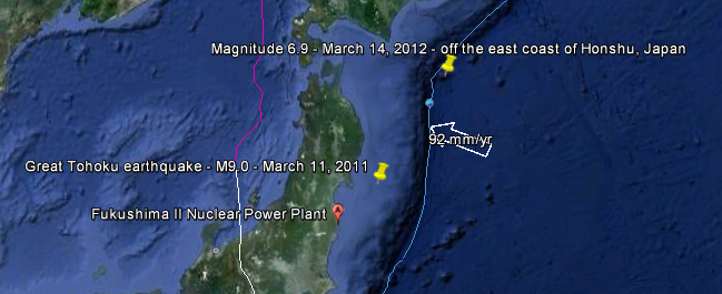
Image credit: TW
Just 3 days after Japan marked the first anniversary of Great Tohoku earthquake and tsunami disaster that followed – a swarm of earthquakes hit the same region of Japan. Although reports of new earthquakes are still coming in – no damage or tsunami was reported. Area that is most affected today is not the same location as on March 11, 2011 as you can see on the map above. The distance between todays swarm and Great Tohoku earthquake is some 361 km (226 miles).
The region, however, is still producing new earthquakes, updates will be added.
Magnitude 6.9 earthquake occured at 09:08:37 UTC according to USGS. Epicenter was located 235 km (146 miles) south of Kushiro, Hokkaido, 265 km (164 miles) southeast of Obihiro, Hokkaido, 293 km (182 miles) east of Hachinohe, Honshu, and 734 km (456 miles) northeast of Tokyo, Japan (40.899°N, 144.923°E). The depth was 26.6 km (16.5 miles). Japan Meteorological Agency registered magnitude 6.8 at depth of 10km. There was no tsunami warning issued by Pacific Tsunami Warning Center and USGS PAGER gave only Green Alert for economic losses and estimated fatalities.
This was a very strong earthquake with epicenter right on the subduction fault line, far out in the sea which weakened the shaking considerably. The Magnitude can be seen as spectacular, but due to the epicenter location, the max. shaking reported by JMA was only 4 (on a scale of 0 to 7).
The main shock was followed by tens of aftershocks
The town of Otsuchi in Iwate prefecture, where more than 800 died in last year’s tsunami, issued an evacuation order to all households along the coast as a precaution, said prefectural disaster management official Shinichi Motoyama. No damage or injury was reported from the quake so far, he said.


Reported by the Japan Meteorological Agency
ORIGIN TIME – 09:08 UTC 14 MAR 2012
COORDINATES – 40.7 NORTH 145.2 EAST
DEPTH – 10 KM
LOCATION – OFF EAST COAST OF HONSHU JAPAN
MAGNITUDE – 6.8
No destructive widespread tsunami threat exists based on historical warthquake and tsunami data.
However – earthquakes of this size sometimes generate local tsunamis that can be destructive along coasts located within a hundred kilometers of the earthquake epicenter. Authoritios in the region of the epicenter should be aware of this possibility and take appropriate action.


Another earthquake measuring 6.1 magnitude occured at 10:49:24 UTC. Epicenter was located 244 km (151 miles) south of Kushiro, Hokkaido, 268 km (166 miles) southeast of Obihiro, Hokkaido, 279 km (173 miles) east of Hachinohe, Honshu and 717 km (445 miles) northeast of TOKYO, Japan (40.799°N, 144.770°E). The depth of epicenter was 9.5 km (5.9 miles) according to USGS.

At 10:57 UTC another one struck exactly the same location, this time magnitude 5.7 with currently reported depth of 21 km. At 11:40 UTC magnitude 5,4 was reported near the same location with depth of 22 km.
Above earthquakes were all located at almost the same location and at sea (LAT 40.899 / LONG 144.923, off the east coast of Honshu) but the next one (magnitude 5.7 with depth of 16.9 km) was reported at 12:05 UTC on land:

Two hours later (at 14:04 UTC) 4.6 magnitude earthquake with depth of 8.6 was reported. The location is in reported region (approx LAT 40.899 / LONG 144.923, off the east coat of Honshu) of where the first quakes started.
it continued…
At 13:41 UTC magnitude 4.9 with depth of 10.7, and at 14:54 UTC a 4.6 magnitude with depth of 7.7 km.
At 21:38:56 UTC near the east coast of Honshu a 5.2 magnitude earthquake occured with depth of 34.6 km (21.5 miles). Exact location is 35.549°N, 141.678°E, 175 km (108 miles) E of TOKYO, Japan. 200 km of Fukushima II Nuclear Power Plant.
At 23:01:56 UTC a 4.6 magnitude with recorded depth of 27.8 km off the east coast of Honshu.

Meanwhile in Papua New Guinea:
A 6.4 magnitude earthquake hit New Britain Region of Papua New Guinea on Wednesday, March 14, 2012 at 21:13:11 UTC (Thursday, March 15, 2012 at 07:13:11 Local). USGS reported it with depth of 47.8 km (29.7 miles). Epicenter was 6 km (59 miles) E of Kimbe, New Britain. 1000 people will have felt a strong shaking, 63,000 people a moderate shaking.
At 00:09:12 UTC – Marhc 15 – a 4.8 magnitude with depth of 11,3 km off the east coast of Honshu.
At 7:50:43 UTC – March 15 – a 4.6 magnitude with depth of 28,2 km off the east coast of Honshu.
And a strong one on a new region…
At 19:20:18 UTC – March 15 – a 5.1 magnitude with depth of 99,9 near the south coast of Honshu

Pacific Ring of Fire
The Pacific Ring of Fire (or just The Ring of Fire) is an area where large numbers of earthquakes and volcanic eruptions occur in the basin of the Pacific Ocean. In a 40,000 km (25,000 mi) horseshoe shape, it is associated with a nearly continuous series of oceanic trenches, volcanic arcs, and volcanic belts and/or plate movements. The Ring of Fire has 452 volcanoes and is home to over 75% of the world’s active and dormant volcanoes. It is sometimes called the circum-Pacific belt or the circum-Pacific seismic belt.

Featured imaga: Google Earth + USGS
Commenting rules and guidelines
We value the thoughts and opinions of our readers and welcome healthy discussions on our website. In order to maintain a respectful and positive community, we ask that all commenters follow these rules.