
Strong earthquake with magnitude 5.6 hit northwestern Kashmir
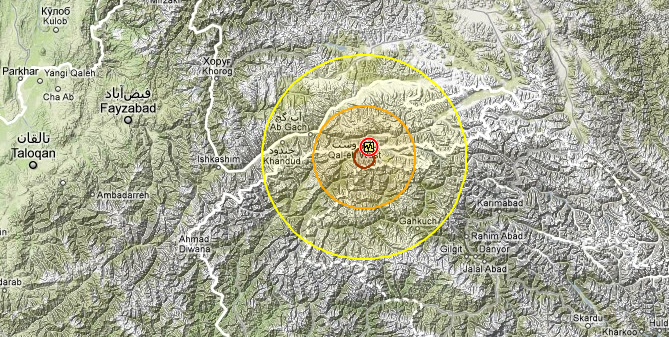
Image credit: Google Earth via RSOE-EDIS
A strong 5.6 magnitude earthquake (reported by USGS) with depth of 49.3 km hit northwestern part of Kashmir on March 12th, 2012 at 06:06 UTC. EMSC reported 5.7 magnitude earthquake with depth of 60 km.
The nearest populated places are: Lasht (13km), Baroghil (19km), Kharach (20km), Dehe Gholaman (18km). The closest civilian airport is Chitral (159km). The Murgab hydrodam is located at a distance of 62 km from the epicenter. No nuclear
Max. expected shaking: moderate for 9,000 people and light shaking: 332,000.
Koyo Zom is the highest peak in the Hindu Raj mountain range in Pakistan at 6872 m. The Hindu Raj mountain range lies between the Hindu Kush and the Karakoram ranges.
Based on the current hypocenter (49.3 km) and the epicenter location (preliminary), earthquake-report calls this earthquake moderately dangerous. The biggest danger will come from landslides and rockfall. Additionally, the houses in the area are mostly build of stones and are very vulnerable.
At 08:26:14 UTC, the same region was struck by another earthquake. This time magnitude 4.5.
| Magnitude | 5.6 |
|---|---|
| Date-Time |
|
| Location | 36.796°N, 73.172°E |
| Depth | 49.3 km (30.6 miles) |
| Region | NORTHWESTERN KASHMIR |
| Distances | 141 km (87 miles) NW of Gilgit, Kashmir 154 km (95 miles) NE of Chitral, Pakistan 162 km (100 miles) ESE of Khorugh, Tajikistan 348 km (216 miles) N of ISLAMABAD, Pakistan |
| Location Uncertainty | horizontal +/- 14.4 km (8.9 miles); depth +/- 9.3 km (5.8 miles) |
| Parameters | NST=226, Nph=229, Dmin=568.8 km, Rmss=0.72 sec, Gp= 43°, M-type=body wave magnitude (Mb), Version=5 |
| Source |
|
| Event ID | usb0008ffg |

Historical seismicity map (1990 – present)

I'm a dedicated researcher, journalist, and editor at The Watchers. With over 20 years of experience in the media industry, I specialize in hard science news, focusing on extreme weather, seismic and volcanic activity, space weather, and astronomy, including near-Earth objects and planetary defense strategies. You can reach me at teo /at/ watchers.news.
Commenting rules and guidelines
We value the thoughts and opinions of our readers and welcome healthy discussions on our website. In order to maintain a respectful and positive community, we ask that all commenters follow these rules.