Tropical Cyclone “Hola” heading toward Loyalty Islands
Tropical Cyclone "Hola" is strengthening between Vanuatu and New Caledonia as it heads toward the Loyalty Islands.
At 09:00 UTC today, the center of Tropical Cyclone "Hola" was located approximately 300 km (187 miles) W of Port Vila, Vanuatu and 507 km (315 miles) N of Noumea, New Caledonia and has tracked SSW at 7 km/h (4.6 mph) over the past six hours. Its maximum sustained winds were 175 km/h (109 mph) with gusts to 213 km/h (132 mph).
This made Hola a Category 4 tropical cyclone on the Fiji intensity scale or a Category 2 hurricane equivalent in the Atlantic.
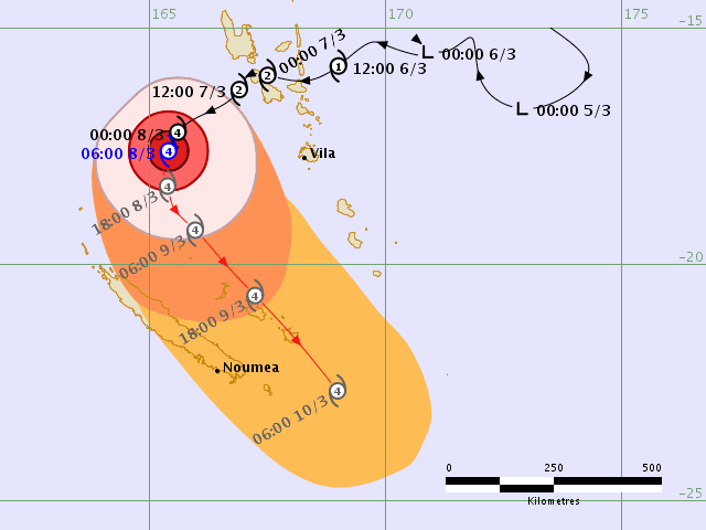
Tropical Cyclone "Hola" RSMC Nadi forecast track at 07:24 UTC on March 8, 2018
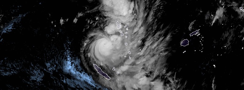
Animated multispectral satellite imagery depicts a small but well defined tropical cyclone with a small eye, JTWC noted 09:00 UTC today.
Although hola is experiencing moderate vertical wind shear, it is benefiting from good equatorward outflow, excellent poleward outflow and favorable sea surface temperatures (29 – 30 °C / 84 – 86 °F).
Hola is expected to track southeastward along the periphery of subtropical ridge located to the east. In the short term, the system will continue to increase in intensity, reaching a peak intensity of 222 km/h (138 mph) by 09:00 UTC, March 9 before beginning to weaken. By 09:00 UTC on March 11, Hola will begin extratropical transition and complete it by 09:00 UTC, March 12.
Tropical Cyclone "Hola" at 10:50 UTC, March 8, 2018. Credit: JMA/Himawari-8
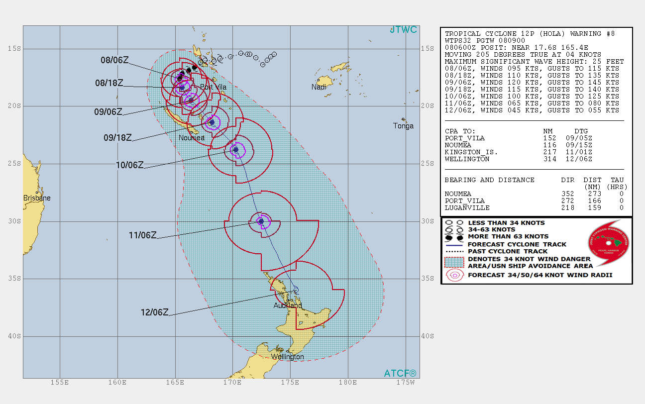
Tropical Cyclone "Hola" JTWC forecast track at 09:00 UTC on March 8, 2018
Dynamic model guidance remains in good agreement over the next 48 hours and calls for a direct hit to Loyalty Islands (population 18 000) as extremely dangerous Category 4 hurricane equivalent.
By the time Hola reaches the islands on March 9, it is expected to have winds of 222 km/h (138 mph) and gusts to 259 km/h (161 mph), strong enough to cause catastrophic damage.
Potential damage: Well-built framed homes can sustain severe damage with loss of most of the roof structure and/or some exterior walls. Most trees will be snapped or uprooted and power poles downed. Fallen trees and power poles will isolate residential areas. Power outages will last weeks to possibly months. Most of the area will be uninhabitable for weeks or months.
Along with powerful winds, Hola is bringing very heavy rain, raising the threat of floods.
The two animations below show ECMWF wind gust and precipitation model:
Hola, or what's left of it, is expected to reach North Island, New Zealand on March 12, bringing heavy rain and damaging winds.
Update
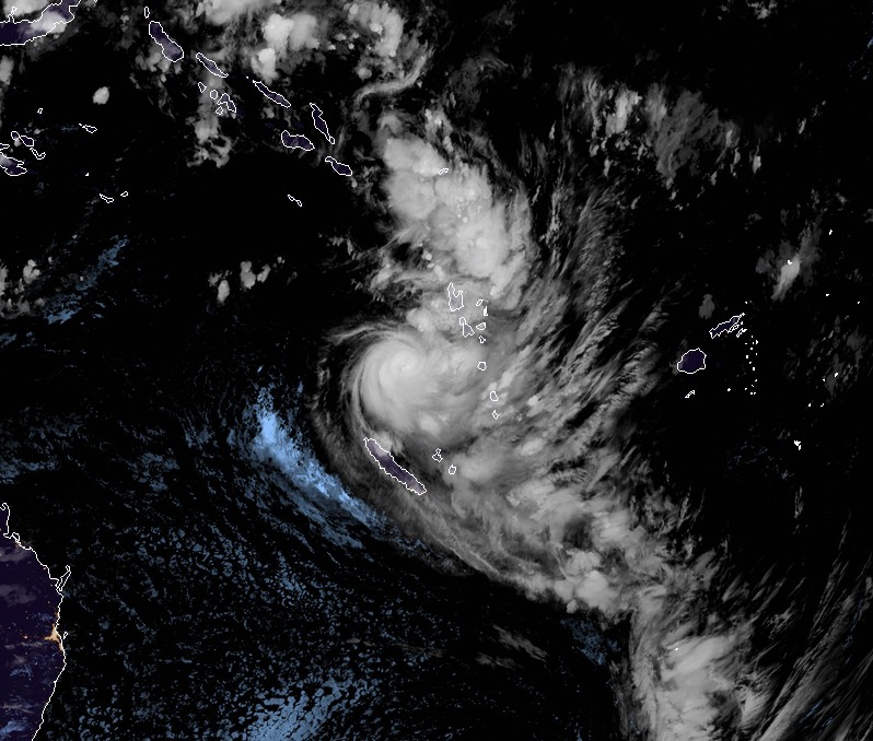
Animated multispectral satellite imagery shows that the convection associated with Tropical Cyclone "Hola" is gradually weakening in intensity, JTWC noted 09:00 UTC on March 9.
The majority of the convection is located to the southeast of the low level circulation center as a result of increasing vertical wind shear.
At the time, Hola's maximum sustained winds were 148 km/h (92 mph) with gusts to 185 km/h (115 mph).
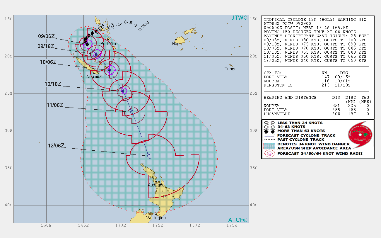
As hola tracks southeastward it will encounter deteriorating environmental conditions which will lead to a decrease in intensity. Hola is expected to begin its extratropical transition by 21:00 UTC, March 10 and complete it by 09:00 UTC, March 12.
"All dynamic model guidance indicates a general southeastward track but there remains a large spread among the consensus members. Therefore, there is a low confidence in the JTWC forecast track," the center said.
Featured image: Tropical Cyclone Hola at 10:50 UTC on March 8, 2018. Credit: JMA/Himawari-8
it looks like a roller… a roller bird