Drone footage of new eruption in Iceland
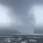
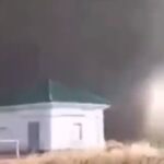
A new volcanic eruption began at 22:17 UTC on December 18, 2023, in Reykjanes, Iceland, near the town of Grindavik.
The eruptive fissure is located about 4 km (2.5 miles) northeast of Grindavik, on Iceland’s Reykjanes Peninsula. The eruptive fissure, approximately 4 km in length, stretches from east of Stóra-Skógfell to near Sundhnúkur. This event was preceded by an earthquake swarm beginning at 21:00 UTC.
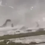
Aerial observations and seismic data as of 02:10 UTC on December 19 indicated the fissure’s expansion southward. Officials have warned that this eruption, located on a dyke intrusion formed in November, is larger and not as accessible to tourists compared to the 2021 Fagradalsfjall eruption.

The latest update from the Icelandic Meteorological Office (IMO) at 18:30 UTC on December 18 reported that the eruption’s intensity is diminishing. Aerial images show three active vents southeast of Stóra-Skógfell, with lava primarily flowing east and a secondary flow to the west. Since the eruption’s onset, around 320 earthquakes have been recorded, including a M4.1 quake. Seismic activity decreased significantly after midnight, with only 10 earthquakes recorded since noon.
Following the eruption at Sundhnúksgíga, land in Svartsengi subsided by over 5 cm (2 inches), reversing some of the 35 cm (14 inches) rise since November 10. The potential for new vents along the original fissure or further north or south remains high. With a short warning time observed for new vent openings, authorities remain vigilant.
Featured image credit: AP (stillshot)


Commenting rules and guidelines
We value the thoughts and opinions of our readers and welcome healthy discussions on our website. In order to maintain a respectful and positive community, we ask that all commenters follow these rules.