
The sea is falling in Juneau, Alaska, because land freed from melted glaciers is rising about 0.6 inches a year
The sea is falling relative to the shoreline in Juneau, Alaska, even as global sea levels rise. Land once pressed down by massive glaciers is rebounding at approximately 15 mm (0.6 inches) per year, lifting the coast faster than the ocean is rising. NOAA’s tide-gauge measurements show a relative sea-level decline of about 13.5 mm (0.53 inches) per year, revealing how centuries of glacier retreat continue to reshape Southeast Alaska’s coastline.
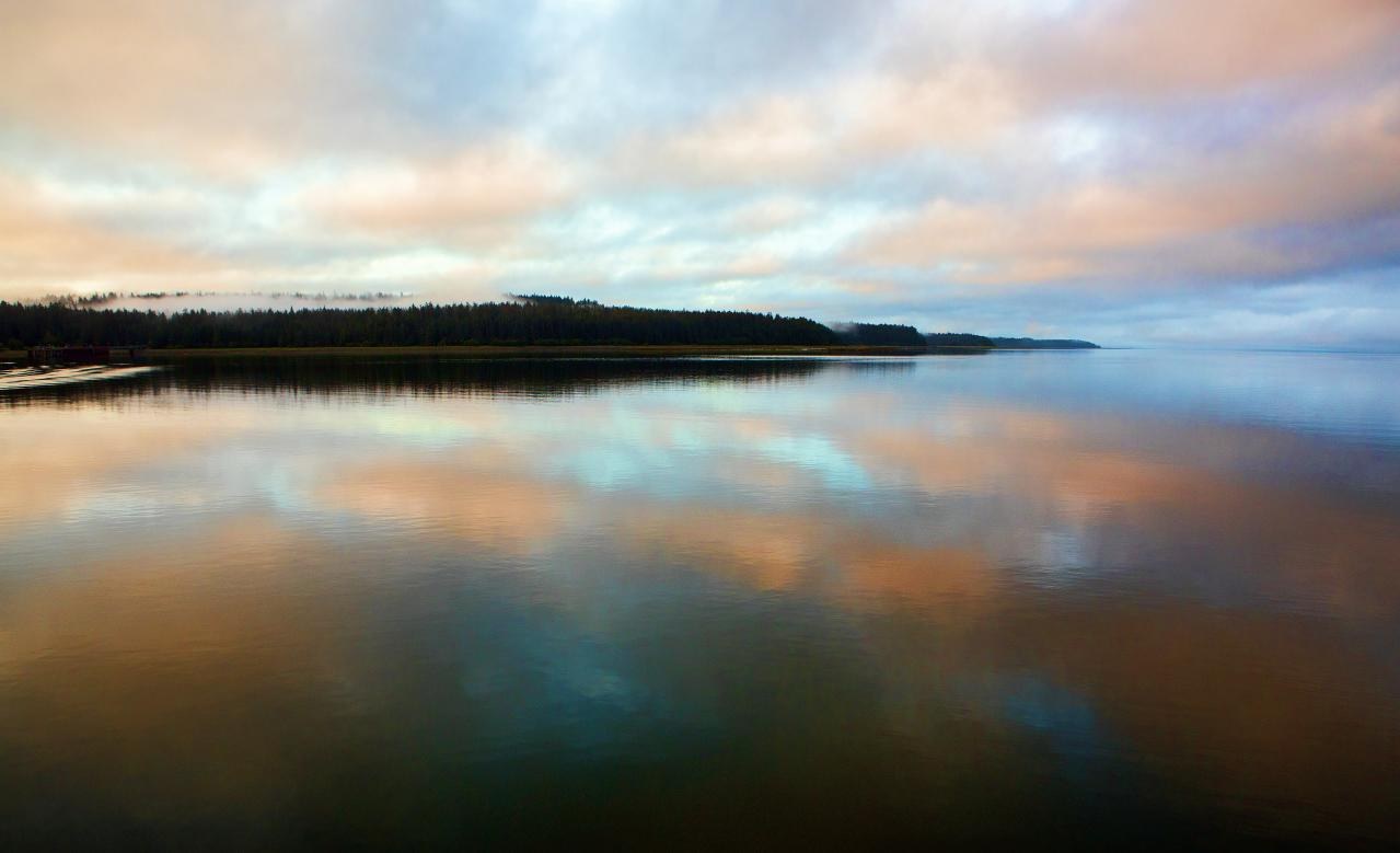
Alaska aboard the Admiralty Dream. Credit: Christopher Michel (CC BY 2.0), via Wikimedia Commons.
NOAA’s tide gauge at Juneau station 9452210 records a sustained decline in mean sea level relative to the land. The station’s long-term trend is approximately -13.5 mm (-0.53 inches) per year. That measurement describes how water height has changed against the local shoreline, not a fall in the global ocean surface.
A tide gauge measures sea level relative to benchmarks on land. When those benchmarks rise, the recorded water level can fall even as the ocean itself gains water. This distinction is central to Juneau, where the vertical movement of the ground is large enough to outweigh the local effect of rising ocean levels.
The mechanism is known as glacial isostatic adjustment. During the Little Ice Age, glaciers and icefields accumulated enough ice to depress the Earth’s crust. As that ice thinned and retreated, its weight was removed. The crust and the underlying mantle have continued adjusting to the reduced load, allowing the land to rise.
The Alaska Coastal Rainforest Center’s Juneau Climate Report, published in July 2022, places average uplift around Juneau at approximately 15 mm (0.6 inches) per year. The estimate comes from geophysical modeling constrained by GPS observations, rather than from a single tide-gauge measurement.

Hu and Freymueller (2019) investigated the pattern of glacial isostatic adjustment across Southeast Alaska using geodetic observations. Their analysis examined changes in vertical land motion over time and how the Earth’s response to glacier mass loss constrains the physical properties of the crust and mantle.
The rate of uplift varies considerably across the region. The Juneau Climate Report identifies rates approaching 30 mm (1.2 inches) per year around Yakutat and Glacier Bay, roughly twice the average rate around Juneau. The geographic differences reflect variations in glacier retreat, the distribution of ice loads and the response of the solid Earth.
GPS stations and tide gauges measure different parts of the process. GPS tracks the changing position of the ground, while tide gauges record the height of the water relative to that ground. Together, they allow researchers to distinguish vertical land motion from changes in relative sea level.
The ice loss responsible for the rebound began long before modern instruments were installed. Glaciers throughout Southeast Alaska retreated substantially after their Little Ice Age maximum, approximately 250 years ago. The response of the land has continued for generations as the Earth’s interior adjusts to the removal of ice.
The accumulated uplift has changed the position of the coastline. The Juneau Climate Report estimates that former shorelines have emerged by approximately 3 m (10 feet) since the late 1700s. That historical estimate is based on evidence of shoreline movement, rather than a simple extrapolation of today’s annual uplift rate.
Research by Roman Motyka used geological and biological evidence to reconstruct the timing of land emergence around Juneau. The findings linked the onset of post-Little Ice Age uplift to glacier retreat and helped establish the longer history behind the modern GPS and tide-gauge observations.
The effects are especially visible in the Mendenhall Wetlands State Game Refuge. As land rises relative to the sea, tidal water reaches some areas less frequently. Surfaces that were once regularly inundated can gradually change in vegetation, habitat characteristics and their relationship to the tidal boundary.
The shifting tideline has consequences for land management as well as habitat. KTOO reported in July 2018 that a Sunny Point property owner and a neighbor had obtained claims to approximately nine acres of newly emerged land. The report described plans to transfer the land to the Southeast Alaska Land Trust for conservation.
The case illustrates how land that was previously submerged can enter a different legal and management category as the shoreline changes. It does not establish that newly emerged land throughout Juneau is subject to active legal disputes.
The Mendenhall Wetlands are also important habitat for migratory birds and other wildlife. As the shoreline advances, maintaining protected tidal habitat requires attention to both ecological changes and the location of conservation boundaries.
The rapid uplift does not mean Southeast Alaska is free from other geological forces. The region lies near active tectonic boundaries, and geodetic models account for tectonic deformation as well as glacier-related loading. The unusually strong uplift around Juneau and Glacier Bay is principally attributed to glacial isostatic adjustment.
The present decline in relative sea level is not necessarily permanent. The Juneau Climate Report estimates that, if uplift continues at a constant rate, land around the city could rise by approximately 1.2 m (3.9 feet) between 2020 and 2100. This is a projection based on an assumed rate, not a measurement of future land motion.
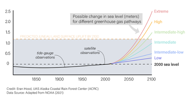
Under the report’s mid-range scenario, relative sea level initially continues to fall before accelerating ocean rise begins to offset the effect of uplift. By 2100, the report estimates that relative sea level could be close to its 2020 position under that scenario, while lower and higher sea-level scenarios produce substantially different outcomes.
The central uncertainty is not whether Juneau’s land has been rising. Both geodetic and tide-gauge observations establish that long-term pattern. The unresolved question for future coastal conditions is how continuing crustal rebound will compare with changes in ocean level over the coming decades.
References:
1 Hu, Y., & Freymueller, J. T. (2019). Geodetic observations of time-variable glacial isostatic adjustment in Southeast Alaska and its implications for Earth rheology. Journal of Geophysical Research: Solid Earth, 124(9), 9870–9889. DOI: 10.1029/2018JB017028
2 Relative mean sea-level trend, Juneau, Alaska, station 9452210 – NOAA Tides & Currents
3 Ocean – Alaska Coastal Rainforest Center, University of Alaska Southeast – July 2022
4 Motyka, R. J. (2003). Little Ice Age subsidence and post Little Ice Age uplift at Juneau, Alaska, inferred from dendrochronology and geomorphology. Quaternary Research. Original paper
5 As lands uplift, a wetland refuge in Juneau is losing ground – KTOO – July 25, 2018

I’m a science journalist and researcher at The Watchers, contributing to the Epicenter edition, where I cover peer-reviewed scientific research and emerging discoveries across Earth and space sciences. With a background in astronomy and a passion for environmental science, I’ve worked in shark and coral conservation in Fiji, conducting reef and shark-behavior research, contributing to mangrove restoration, and earning PADI Open Water and Coral Reef Certifications. I bring a blend of scientific rigor and storytelling to illuminate the discoveries shaping our planet and beyond.
Published in the last 24 hours
- A dam above Los Angeles collapsed just before midnight on March 12, 1928, and the flood killed more than 400 people, hours after the engineer who built it had spent two hours looking at a new leak and decided there was no danger Epicenter
- In 1903, 17 coal miners in Frank, Alberta, dug their own way out of a mountain after a rockslide sealed the mine, and came up 13 hours later to find part of their town buried Epicenter
- Brownsville, Texas, on the Mexican border, had not seen measurable snow since 1895, until it fell on Christmas Eve 2004 Epicenter
- China's giant sinkholes shelter endangered Magnolia but leave isolated populations genetically vulnerable Epicenter
