
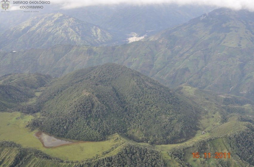
Increased seismicity under Machín volcano, Colombia
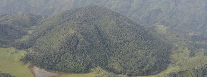
Image credit: Servicio Geológico Colombiano
Seismicity under Machín volcano started increasing at 11:23 LT on December 2, 2022, with signals indicating rock fracturing. This small but explosive volcano is located at the southern end of the Ruiz-Tolima massif. Its last eruption took place in 1180 CE.
By 13:20 LT, a total of 393 signals were detected. The largest event was M4.5 detected at 12:36 LT, located about 900 m (2 900 feet) SSW of the main dome at a depth of 3 km (1.8 miles).1
The quake was felt in Cajamarca (14 km / 8.7 miles WSW), Ibagué (17 km / 10.5 miles ESE), and in other municipalities of Tolima.
The Alert Level remains at Yellow — the second lowest level on a four-color scale.
According to news articles published in mid-May 2004, INGEOMINAS reported that there had been an increase in seismicity at Machín in April. About 60 earthquakes were recorded daily (in comparison to the 1-10 earthquakes normally recorded); however, no surface changes were seen at that time at the volcano.2
There was no further significant seismic activity until the first week of January 2008 when INGEOMINAS reported unusual seismicity at Machín from January 6 to 8. On January 7, the volcano-tectonic seismic signals were occasionally felt and reported by nearby residents.
The simultaneous occurrence of both types of seismic signals was unusual for Machín.
Again, the activity diminished to the previous background levels until November 9 when INGEOMINAS reported a cluster of ~375 earthquakes, the majority of which were located towards the E sector and below the dome of the volcano with depths between 2.5 and 5 km (1.5 – 3 miles).
The earthquake activity occurred underneath the central and E parts of the lava dome complex in the summit caldera and fumarolic activity in the area increased.
From November 8 to 10, 2008, Machín registered 1 210 volcano-tectonic earthquakes, 9 of which had a magnitude of 2.5.
According to news articles, approximately 400 – 450 people evacuated to shelters or other safe areas. There were also reports of landslides that blocked a highway.
There were two significant seismic events at Machín in 2009.
Increased seismicity was also reported in 2010 and 2011.
The last eruption at this volcano took place in the year 1180 CE ± 150 years (VEI unknown).
Geological summary
The small Cerro Machín stratovolcano lies at the southern end of the Ruiz-Tolima massif about 20 km (12.4 miles) WNW of the city of Ibagué.
A 3 km (1.8 miles) wide caldera is breached to the south and contains three forested dacitic lava domes. Voluminous pyroclastic flows traveled up to 40 km (24.8 miles). away during eruptions in the mid-to-late Holocene, perhaps associated with formation of the caldera.
Late-Holocene eruptions produced dacitic block-and-ash flows that traveled through the breach in the caldera rim to the west and south.
The latest known eruption of took place about 800 years ago.3
References:
1 Global Volcanism Program, 2022. Report on Machin (Colombia). In: Sennert, S K (ed.), Weekly Volcanic Activity Report, 30 November-6 December 2022. Smithsonian Institution and US Geological Survey.
2 Machin – Bulletin reports April 2011 – GVP
3 Machin – Geological summary – GVP
I'm a dedicated researcher, journalist, and editor at The Watchers. With over 20 years of experience in the media industry, I specialize in hard science news, focusing on extreme weather, seismic and volcanic activity, space weather, and astronomy, including near-Earth objects and planetary defense strategies. You can reach me at teo /at/ watchers.news.
Commenting rules and guidelines
We value the thoughts and opinions of our readers and welcome healthy discussions on our website. In order to maintain a respectful and positive community, we ask that all commenters follow these rules.