
Severe storms bring baseball-sized hail, heavy rain, and damaging winds to Minnesota, U.S.
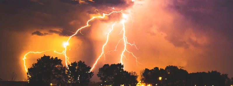
Image credit: Max LaRochelle/Unsplash
Bouts of severe storms lashed Minnesota with large hail, continuous lightning, damaging winds, and torrential rain Sunday into Monday, August 10, 2020. Electricity was disrupted to more than 10 000 homes and businesses. Several communities picked up over 102 mm (4 inches) of rain in a day, which is more than a month's worth of rainfall in the state.
The storms prompted severe thunderstorm warnings across the southern half of the Twin Cities metro area and dumped large hail in areas including Loretto, Carver, and Minnesota before 03:00 UTC on August 10 (20:00 LT on August 9).
In Bloomington, many uprooted trees and limbs blocked roads throughout the city, mainly in the area between Normandale Boulevard to Xerxes Avenue, from 90th Street to American Boulevard. The storm was accompanied by winds up to 97 km/h (60 mph).
"Fire crews have been responding to numerous incidents since the storms started last evening. Many trees and limbs blocking roads throughout the city," the fire department reported.
Wide swaths of the state's west metro were hit by strong hailstorm with hailstones as big as baseballs. Lightning and thunder were nearly continuous for much of the night across the metro area.
"I have rarely seen lightning this continuous. This is a tornado alley-level lightning show," said Paul Huttner, chief meteorologist of Minnesota Public Radio.
I have rarely seen lightning this continuous. This is a tornado alley-level lightning show. #mnwx pic.twitter.com/SY1k6DLmBa
— MPR Weather (@MPRweather) August 10, 2020
Close to baseball size hail in Loretto tonight @NWSTwinCities @FOX9 @kare11 @WCCO pic.twitter.com/PMHbiYg7I3
— Alexandra Zeman (@alexandrazeman) August 10, 2020
Nearly continuous lightning looking west in South St. Paul as of 1:45a #mnwx pic.twitter.com/FFiTpXQApo
— Andrew Krueger (@akpix) August 10, 2020
At 14:10 UTC on Monday (09:10 LT), Xcel Energy reported that more than 10 000 homes and businesses lost power in the wake of the storms, mostly in the south and west metro areas.
Several communities recorded more than 102 mm (4 inches) of rain in one night, which was more than a month's worth of rain. Minnesota has an average rainfall of about 91.4 mm (3.6 inches) for the month of August.
"We're hearing terrible news about crop and structure damage from last night's storm in MN. Please keep our farmers in your thoughts," the Minnesota Farmers Union posted on Tuesday, August 11.
According to the National Weather Service, near to slightly above normal temperatures will persist through the week, with occasional showers and thunderstorms likely from Wednesday, August 12, into the weekend.
Commenting rules and guidelines
We value the thoughts and opinions of our readers and welcome healthy discussions on our website. In order to maintain a respectful and positive community, we ask that all commenters follow these rules.