
Study shows ground may start ‘wobbling’ months prior to a giant earthquake

Image credit: Sushil Kumar/Flickr
A new study by an international team of geoscientists shows that a strange reversal of ground motion occurred prior to two of the biggest earthquakes in history– the M8.8 great Maule quake in 2010 and the M9 Tohoku-Oki quake in 2011, which triggered a catastrophic tsunami and the Fukushima nuclear meltdown. The researchers hope that these movements they call "wobbles" could alert seismologists in the future, and give countries enough time to prepare for a disaster.
The 2011 earthquake in Japan was the strongest in the country's recorded history– the landmasses yanked from east to west, and then east again months before the devastating event that killed more than 15 500 people.
These movements or wobbles occur when one of the Earth's tectonic plates slip under another, which jams up the planet until it is broken, resulting in an earthquake.
"What happened in Japan was an enormous but very slow wobble – something never observed before," said co-author Michael Bevis, a professor of earth sciences at Ohio State University.
"But are all giant earthquakes preceded by wobbles of this kind? We don't know because we don't have enough data. This is one more thing to watch for when assessing seismic risk in subduction zones like those in Japan, Sumatra, the Andes, and Alaska."
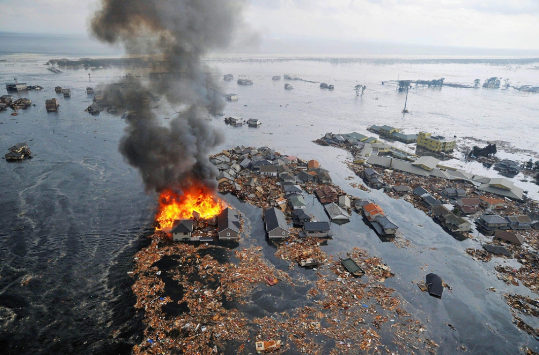
2011 Tohoku-Oki earthquake. Image credit: Sushil Kumar/Flickr
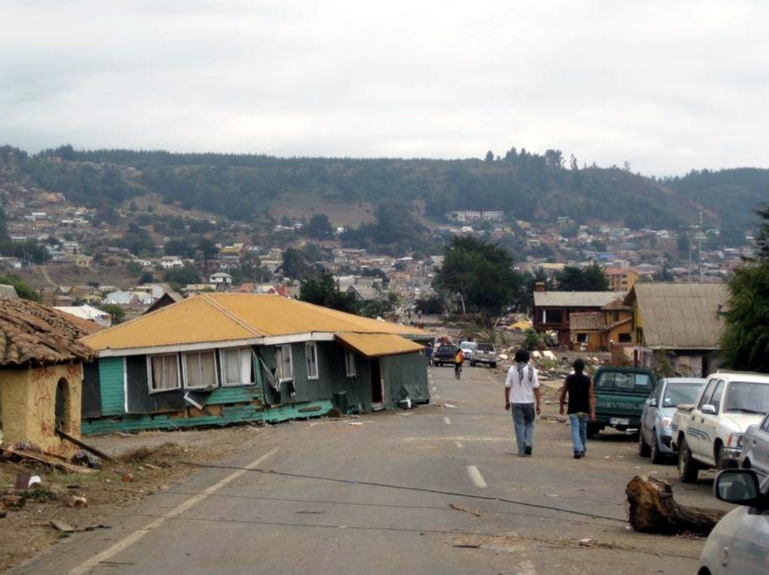
2010 Maule earthquake. Image credit: Wikimedia
Bevis added that although people standing on the island would not have been able to detect or notice the wobble as the movement is just a few millimeters per month over a period of five to seven months, the movement was evident in data recorded by more than 1 000 GPS stations throughout Japan.
Geoscientists from Germany, Chile, and the U.S. analyzed the data and found a reversing shift about 4 to 8 mm (0.2 to 0.3 inches) east, then to the west, and to the east again. The team explained that those movements were markedly different from the steady shifts that the landmasses continuously generate.
"The world is broken up into plates that are always moving in one way or another. Movement is not unusual. It's this style of movement that's unusual," said Bevis.
The professor noted that the wobble could indicate that in the months before the tremor, the plate under the Philippine Sea had a "slow slip event", a gentle underthrusting of two adjoining oceanic plates under Japan, which eventually triggered a huge westward and downward sway. This drove the Pacific plate and slab beneath Japan, producing powerful seismic waves that pounded the entire country.
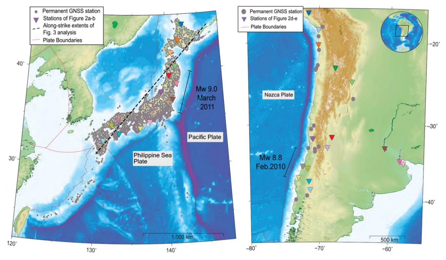
GNSS stations in Japan and Chile. Image credit: Bedford et al.
The event inflicted widespread damage throughout Japan, also causing large parts of Honshu island to be permanently shifted a few meters to the east. It triggered a tsunami that reached more than 40 m (131 feet), and more than 450 000 were left homeless. Several nuclear reactors at the Fukushima Daiichi power plant sent a stream of toxic and radioactive materials into the atmosphere as it melted. Overall, it was the worst nuclear disaster since Chernobyl.
Scientists who study seismic activities and plate tectonics try to identify the approximate magnitude of the next massive earthquake and forecast where and when they may take place. However, lead author Jonathan Bedford, also a researcher at the GFZ, explained that GPS systems are needed in some subduction zones around the world in order to use the findings of the study to predict quakes.
Japan had one of the largest GPS monitoring systems in the world in 2011, which provided the country with sufficient data and allowed the researchers to analyze the landmass' swinging movements months before the event.
Chile and Sumatra were also hit by catastrophic earthquakes and tsunamis in 2010 and 2004, respectively, but they had less-comprehensive systems during those times.
The team studied similar data from the 2010 Maule quake in Chile. The network is not as dense, but still tracked much of the deforming continental plate.
The stations on land normally move away slightly from the subduction trench as the continental crust is mashed and shortened. However, by analyzing the time sequences of GNSS signals, the researchers found evidence of a wobble– stations suddenly shifted towards the subduction trench and reversed their direction again, back to the normal movement.
Shortly after the second reversal, the underground tore, followed by the massive quakes. Bedford explained that it was "only just good enough to capture the signal."
The team hopes that by tracking wobbles, nations at risk will be alerted and given more time to prepare for an upcoming disaster, and a sensor network is necessary for this.
"We really need to be monitoring all major subduction zones with high-density GPS networks as soon as possible."
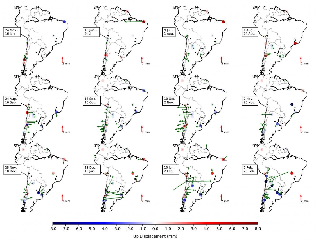
Motion of tectonic plates changed in direction and speed months before the massive earthquake. Image credit: Bedford et al.
References
"Months-Long thousand-kilometer-scale wobbling before great subduction earthquakes" – Bedford, J. et al. – Nature – https://doi.org/10.1038/s41586-020-2212-1
Abstract
Megathrust earthquakes are responsible for some of the most devastating natural disasters1. To better understand the physical mechanisms of earthquake generation, subduction zones worldwide are continuously monitored with geophysical instrumentation. One key strategy is to install stations that record signals from Global Navigation Satellite Systems2,3 (GNSS), enabling us to track the non-steady surface motion of the subducting and overriding plates before, during and after the largest events4,5,6. Here we use a recently developed trajectory modeling approach7 that is designed to isolate secular tectonic motions from the daily GNSS time series to show that the 2010 Maule, Chile (moment magnitude 8.8) and 2011 Tohoku-oki, Japan (moment magnitude 9.0) earthquakes were preceded by reversals of 4–8 millimeters in surface displacement that lasted several months and spanned thousands of kilometers. Modeling of the surface displacement reversal that occurred before the Tohoku-oki earthquake suggests an initial slow slip followed by a sudden pulldown of the Philippine Sea slab so rapid that it caused a viscoelastic rebound across the whole of Japan. Therefore, to understand better when large earthquakes are imminent, we must consider not only the evolution of plate interface frictional processes but also the dynamic boundary conditions from deeper subduction processes, such as sudden densification of the metastable slab.
Commenting rules and guidelines
We value the thoughts and opinions of our readers and welcome healthy discussions on our website. In order to maintain a respectful and positive community, we ask that all commenters follow these rules.