
Powerful storm to produce multiple hazards in the West and Plains, heavy snow, record low temperatures and blizzard conditions, USA
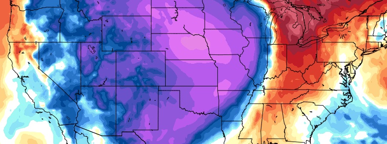
Image credit: GFS, TropicalTidbits
A powerful storm system is set to spin up the Northern Rockies and High Plains the following days, possibly bringing record low temperatures across the western U.S. through October 10 and 11, 2019. Heavy snow is expected from the North-Central Rockies into the Northern Plains/Upper Midwest, very cold temperatures across the West, fire weather threats from California into the Great Basin and severe thunderstorms for the south-central Plains.
National Weather Service (NWS) said the cold front and a strong upper-level trough are expected to head across the western U.S. on October 9, crossing the Great Basin and the north-central Rockies in the evening hours.
The major storm is also in the process of dumping up to 60 cm (2 feet) of snow on October 9 over the Northern Rockies and Northern High Plains. Moreover, blizzard conditions will be felt farther to the east.
By Thursday night, October 10, low pressure is expected to develop along the front across the Upper Midwest, while now will continue to fall west of the low across the Northern Plains.
We’ve got snow accumulating out on the West Plains along I-90 and US 2. If you are out driving this evening please slow down for conditions and use caution. pic.twitter.com/s0tTjyBkZ7
— WSDOT East (@WSDOT_East) October 9, 2019
The heaviest snow, measuring at least 15 cm (6 inches), is expected to lash Montana, Wyoming, and Colorado. Central and western Dakotas also have chances of receiving feet of snow.
Aside from heavy snow, strong gusty winds may also occur which could make travel conditions difficult. Windy conditions will reach farther south which could also lead to critical fire weather conditions from parts of California and the Great Basin east to the central Rockies.
Snow falling across portions of Montana through the night will lead to slippery travel and reduced visibility for motorists: https://t.co/D7MBquCeEF pic.twitter.com/OjDfourwnP
— AccuWeather (@breakingweather) October 9, 2019
According to AccuWeather, "The storm system will bring another round of early-season accumulating snow to nearly a half a million square miles of the interior United States, and, in some cases, the snow will fall less than 24 hours after temperatures hover in the 50s, 60s, 70s, and 80s (°F) [10 – 25 °C] ."
Record low temperatures are possible from the Northwest to the northern Great Basin and east into the Rockies by Friday morning, October 11.
"The rapid, intense freeze could have major impacts on trees and shrubs that remain in full leaf in many parts of the region, including the Denver area, following one of the warmest Septembers on record," TWC meteorologists said.
"It may also lead to a flash freeze on roads in areas where rain or light wet snow melting on roads is immediately followed by subfreezing temperatures behind the cold front."
Furthermore, NWS reported, "The system is expected to produce heavy rainfall and gusty winds across portions of southern New England. 25 – 100 mm (1 to 4 inches) of rain is possible through Thursday night, with the heaviest amounts expected to fall across eastern Massachusetts (including the islands), where amounts in excess of 100 mm (4 inches) are possible. Farther south, scattered to numerous (locally heavy) showers and thunderstorms are forecast ahead of the front across the Florida Peninsula."
Commenting rules and guidelines
We value the thoughts and opinions of our readers and welcome healthy discussions on our website. In order to maintain a respectful and positive community, we ask that all commenters follow these rules.