
Mayon volcano’s status lowered to Alert Level 2, Philippines
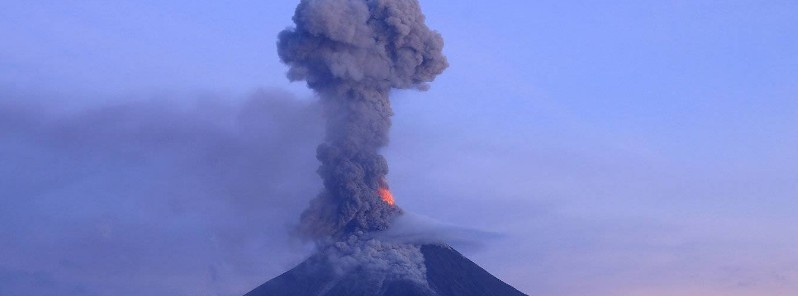
Image credit: Jaime S. Sincioco @jaimessincioco
The Philippine Institute of Volcanology and Seismology (PHIVOLCS) lowered the Alert Level for Mayon volcano from 3 to 2 on March 29, 2018. The lowering of the alert status from Alert Level 3 to Alert Level 2 signifies the cessation of eruptive activity and the decline to a moderate level of unrest. However, the lowering of the alert status should not be interpreted to mean that the volcano’s unrest has ceased, considering that the edifice is still inflated relative to its baseline level.
Mayon’s volcano monitoring network and active observation of day-to-day conditions have recorded a general decline in unrest, as indicated by the following monitored parameters:
1. Volcanic earthquake activity:
For the past two weeks, seismic activity has waned from a peak of 82 to less than 10 rockfall events attributed to the collapse of unstable lava flow deposits on the Miisi, Bonga and Basud drainage systems.
Low frequency earthquakes associated with magma degassing and short ash plumes were last recorded on March 15, 2018, although lava flow effusion from the crater could be detected until March 18, 2018. The overall decline in seismicity indicates that there is currently no active transport of eruptible magma to the shallow levels of the edifice.
2. Ground deformation:
Since February 20, 2018, medium-term deflation of Mayon’s edifice has been recorded by electronic tilt and Precise Leveling (PL) surveys despite short-term episodes of inflation of its lower and middle slopes.
The downtrend in ground deformation follows a period of continuous inflation that began in October-November 2017 and implies that magma recharge from deep to shallower levels of the edifice has decreased. Based on medium-term PL data, nonetheless, the volcano is still inflated relative to January 2010 baselines, most likely due to the presence of remnant magma beneath the edifice.
3. Volcanic degassing:
Magmatic sulfur dioxide or SO2 flux measured for the past two weeks has fluctuated within the range of 500 – 2 000 tonnes/day, which is lower than 700 – 4 500 tonnes/day for the period of eruption from January 13, 2018 to March 8, 2018. The current concentrations of SO2 reflect the diminishing volumes of gas exsolved from unreplenished magma beneath the edifice as well as from cooling lava deposits on the summit and volcanic slopes.
4. Visual parameters:
Since the last observation of lava effusion on March 18, 2018, no new lava has been detected on Mayon’s summit crater. Crater glow, which is incandescence associated with superheated gas emission at the summit vent, has diminished from intense to faint.
Gravity-driven lava flow has begun to stabilize, producing less rockfall and infrequent pyroclastic density currents, the last of which occurred on March 27, 2018. The decline in observable surface parameters is consistent with the cessation of magma supply to the shallow levels of the volcanic edifice.
Avoid 6-km Permanent Danger Zone
The lowering of the alert status from Alert Level 3 to Alert Level 2 signifies the cessation of eruptive activity and the decline to a moderate level of unrest, PHIVOLCS said.
However, the lowering of the alert status should not be interpreted to mean that the volcano’s unrest has ceased, considering that the edifice is still inflated relative to its baseline level.
If there is a resurgence of volcanic unrest based on any one or combination of the above monitoring parameters, the alert status may step up to Alert Level 3 again, the agency added.
On the other hand, if there is a noticeable return to baseline levels of ground deformation and sustained low levels of other parameters, then the Alert Level may further step down.
The public is still reminded to avoid entry into the 6-km (3.7 miles) Permanent Danger Zone or PDZ due to perennial hazards of rockfalls, avalanche, ash puffs and sudden steam-driven or phreatic eruptions at the summit area.
Furthermore, people living in valleys and active river channels are cautioned to remain vigilant against sediment-laden stream flows and lahars in the event of prolonged and heavy rainfall.
I'm a dedicated researcher, journalist, and editor at The Watchers. With over 20 years of experience in the media industry, I specialize in hard science news, focusing on extreme weather, seismic and volcanic activity, space weather, and astronomy, including near-Earth objects and planetary defense strategies. You can reach me at teo /at/ watchers.news.
Commenting rules and guidelines
We value the thoughts and opinions of our readers and welcome healthy discussions on our website. In order to maintain a respectful and positive community, we ask that all commenters follow these rules.