
Ex-cyclone “Cook” slams into New Zealand, thousands without power
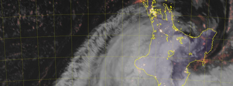
Featured image: Ex-tropical Cyclone "Cook" hits New Zealand - 07:00 UTC, April 13, 2015. Credit: JMA/Himawari-8, CIRA/RAMMB
Ex-tropical Cyclone "Cook" hit North Island, New Zealand around 07:00 UTC (19:00 NZST) on Thursday, April 13, 2017, bringing strong winds and dumping heavy rain on already saturated soil. The cyclone downed trees and power lines, caused severe traffic disruptions and left thousands without power. At least two people were injured after a tree fell onto their car.
Cook's remnants made landfall between Tauranga and Whakatane in the Bay of Plenty, and continued tracking south over Hawke's Bay, flooding homes and downing trees and power lines.
The cyclone was centered over northern Wairarapa at 01:00 NZST on Friday, April 14 and was just off the South Wairarapa at 03:00 NZST, moving south and weakening.
In Hawke's Bay, more than 9 000 people lost power and about 1 400 in the Bay of Plenty. As of 05:00 NZST (17:00 UTC on April 13) they are still without power and Civil Defence is urging people to remain inside and not go sightseeing in the morning.
Wind speed estimates at the time of landfall are between 100 and 120 km/h (62 – 74 mph) while the atmospheric pressure was at 970 hPa. According to NZ Coast Guard, White Island saw wind gusts over 200 km/h (124 mph). MetService said their anemometers have been knocked out in Whakatane.
A number of roads were closed in West Auckland as well as north of the city, in Wellsford and Warkworth, due to flooding.
At least two people were injured after a tree fell on their car and were taken to a hospital. It is still unclear how badly were they injured.
Damage reports are expected in a couple of hours (at 17:55 UTC on Thursday (time of press) it is 05:55 on Friday, April 14 in New Zealand).
The remnants of #CycloneCook will continue to bring some very heavy rainfall and strong winds to #NewZealand over the next few days pic.twitter.com/AJ0Qgjzvw8
— Met Office (@metoffice) April 13, 2017
According to WatherWatch, Cook will be centered near Christchurch by Friday morning if current modeling stays true. Downpours may be intense in south Canterbury and coastal Otago for a time on Friday morning.
"There is some concern in Dunedin and coastal Otago from flooding – the downside (at this stage) with Cyclone Cook is that the low itself will likely slow down around the lower South Island and this could feed persistant rain into the area."
I'm a dedicated researcher, journalist, and editor at The Watchers. With over 20 years of experience in the media industry, I specialize in hard science news, focusing on extreme weather, seismic and volcanic activity, space weather, and astronomy, including near-Earth objects and planetary defense strategies. You can reach me at teo /at/ watchers.news.
Commenting rules and guidelines
We value the thoughts and opinions of our readers and welcome healthy discussions on our website. In order to maintain a respectful and positive community, we ask that all commenters follow these rules.