Strong and shallow M6.0 earthquake hits Mindanao, Philippines
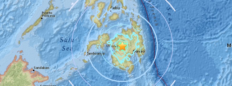
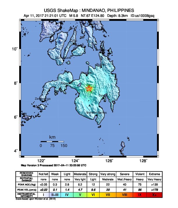
A strong and shallow earthquake registered by the PHIVOLCS as M6.0 hit the island of Mindanao, Philippines at 21:21 UTC on April 11, 2017 (05:21 local time on April 12). The agency is reporting a depth of 1 km (0.62 miles). USGS is reporting M5.8 at a depth of 8.3 km (5.1 miles).
The epicenter is located 13 km (8 miles) northwest of Wao, Lanao del Sur, PHIVOLCS said. This is about 780 km (484 miles) SSE of the ongoing Batangas earthquake swarm.
The quake was generated by the movement of a northwest trending active fault in the area. Small-magnitude earthquakes followed afterward, and as of 07:00 UTC (15:00 local time) on April 12, 73 aftershocks have been recorded by PHIVOLCS seismic monitoring network.
Based on preliminary intensity reports, the strongest ground shaking was felt at PHIVOLCS Earthquake Intensity Scale (PEIS) VII (Destructive) in Wao, Lanao del Sur and Kalilangan, Bukidnon. Furthermore, it was felt at PEIS VI (Very Strong) in Amai Manabilang, Lanao del Sur; PEIS V (Strong) in Pangantukan, Bukidnon, and Banisilan, Cotabato. It was also felt at PEIS IV in Cagayan de Oro City, Iligan City, Cotabato City, Gingoog City in Misamis Oriental, Matalam in North Cotabato, Valencia and Maramag in Bukidnon, and Davao City. This was felt at PEIS III to I in Kabacan and Arakan in North Cotabato, Quezon and Don Carlos in Bukidnon, Pikit in Cotabato, Lebak in Sultan Kudarat, Kidapawan City, Koronadal City, and Mambajao in Camiguin. Damages to some buildings and roads due to strong ground shaking were reported near the epicentral area. Landslides were also reported in Amai Manabilang (Bumbaran). At the time of writing, there are no reports of casualties.
At least one person was injured and 500 homes were damaged, Municipal Disaster Risk Reduction Office said.
"The origin of the earthquake and its subsequent aftershocks are clearly tectonic," PHIVOLCS said. "They don't indicate volcanic activity."
"The current available seismic information suggests this was the main shock, which caused the strong ground shaking. The succeeding small-magnitude earthquakes are the aftershocks which may continue to occur for several days to weeks, some of which may be felt," the agency said.
Aside from strong ground shaking, what other seismic hazards are life-threatening?
Landslides, rock falls, and other types of mass movements may occur in mountainous or hilly areas. Liquefaction, manifested by sand boils or lateral spread may affect low-lying, water-logged, sandy areas at the banks of rivers. Tsunami is not expected because the source of the 12 April 2017 event is on land. The tsunami threat for Lanao del Sur would come from the movement of the Cotabato Trench, located south of the province. However, Lake Lanao may be disturbed and may result to a phenomenon called seiche. Seiche is a temporary oscillation in an enclosed body of water such as lakes caused by strong ground shaking. This phenomenon was observed during the 1955 Magnitude 7.5 Lanao Earthquake.
What should be done by the affected communities?
People are reminded to be cautious of houses and buildings and other structures visibly weakened or with signs of damage by the 12 April 2017 earthquake as these may be further damaged by aftershocks. In case of houses and other buildings with visible damage, it is best to contact the Municipal/City Engineering Office for advice. Engineers from the local government, other agencies and organizations should inspect houses and other structures to determine their integrity and recommend appropriate actions to concerned affected groups or individuals. Slopes should be checked for tension cracks that may have resulted from the strong ground shaking. Tension cracks may make slopes more susceptible to landslides. These areas should also be avoided.
The best course of action is preparedness. In case of another felt earthquake, it is recommended that people protect themselves by doing the “duck, cover and hold”. In houses and offices, cabinets should be strapped to the walls, and appliances be secured to prevent them from toppling and causing injuries injury to persons.
Large magnitude earthquake has affected Lanao del Sur in the past!
On April 1, 1955, a magnitude 7.5 earthquake was experienced in Lanao area. This earthquake, which is considered to be one of the most damaging historical earthquakes in Lanao del Sur, resulted to about 400 deaths. Strong ground shaking was also felt during this event, resulting to significant damage to infrastructures including a mosque in Tugaya municipality near Lake Lanao. Several houses also collapsed and wharfs were damaged in Zamboanga City and Pagadian City. Liquefaction and landslides were also documented.
Aside from this, several small to moderate earthquakes have also been recorded within the province, with intensities ranging from PEIS IV to VII.
Why do earthquakes occur in Lanao del Sur?
Central Mindanao, including Lanao del Sur, is one of the seismically active areas in the country because of the presence of the western extension of the Mindanao Fault (Cotabato-Sindangan Fault), an active fault that runs from Sarangani province to northwest of Zamboanga Peninsula. Cotabato Trench is also a major source of earthquakes which can affect the region. In addition, there exist other local active faults, which can be sources of small- to moderate-magnitude earthquakes. (PHIVOLCS)
Seismotectonics of the Philippine Sea and vicinity
The Philippine Sea plate is bordered by the larger Pacific and Eurasia plates and the smaller Sunda plate. The Philippine Sea plate is unusual in that its borders are nearly all zones of plate convergence. The Pacific plate is subducted into the mantle, south of Japan, beneath the Izu-Bonin and Mariana island arcs, which extend more than 3,000 km along the eastern margin of the Philippine Sea plate. This subduction zone is characterized by rapid plate convergence and high-level seismicity extending to depths of over 600 km. In spite of this extensive zone of plate convergence, the plate interface has been associated with few great (M>8.0) ‘megathrust’ earthquakes. This low seismic energy release is thought to result from weak coupling along the plate interface (Scholz and Campos, 1995). These convergent plate margins are also associated with unusual zones of back-arc extension (along with resulting seismic activity) that decouple the volcanic island arcs from the remainder of the Philippine Sea Plate (Karig et al., 1978; Klaus et al., 1992).
South of the Mariana arc, the Pacific plate is subducted beneath the Yap Islands along the Yap trench. The long zone of Pacific plate subduction at the eastern margin of the Philippine Sea Plate is responsible for the generation of the deep Izu-Bonin, Mariana, and Yap trenches as well as parallel chains of islands and volcanoes, typical of circum-pacific island arcs. Similarly, the northwestern margin of the Philippine Sea plate is subducting beneath the Eurasia plate along a convergent zone, extending from southern Honshu to the northeastern coast of Taiwan, manifested by the Ryukyu Islands and the Nansei-Shoto (Ryukyu) trench. The Ryukyu Subduction Zone is associated with a similar zone of back-arc extension, the Okinawa Trough. At Taiwan, the plate boundary is characterized by a zone of arc-continent collision, whereby the northern end of the Luzon island arc is colliding with the buoyant crust of the Eurasia continental margin offshore China.
Along its western margin, the Philippine Sea plate is associated with a zone of oblique convergence with the Sunda Plate. This highly active convergent plate boundary extends along both sides the Philippine Islands, from Luzon in the north to the Celebes Islands in the south. The tectonic setting of the Philippines is unusual in several respects: it is characterized by opposite-facing subduction systems on its east and west sides; the archipelago is cut by a major transform fault, the Philippine Fault; and the arc complex itself is marked by active volcanism, faulting, and high seismic activity. Subduction of the Philippine Sea Plate occurs at the eastern margin of the archipelago along the Philippine Trench and its northern extension, the East Luzon Trough. The East Luzon Trough is thought to be an unusual example of a subduction zone in the process of formation, as the Philippine Trench system gradually extends northward (Hamburger et al., 1983). On the west side of Luzon, the Sunda Plate subducts eastward along a series of trenches, including the Manila Trench in the north, the smaller less well-developed Negros Trench in the central Philippines, and the Sulu and Cotabato trenches in the south (Cardwell et al., 1980). At its northern and southern terminations, subduction at the Manila Trench is interrupted by arc-continent collision, between the northern Philippine arc and the Eurasian continental margin at Taiwan and between the Sulu-Borneo Block and Luzon at the island of Mindoro. The Philippine fault, which extends over 1,200 km within the Philippine arc, is seismically active. The fault has been associated with major historical earthquakes, including the destructive M7.6 Luzon earthquake of 1990 (Yoshida and Abe, 1992). A number of other active intra-arc fault systems are associated with high seismic activity, including the Cotabato Fault and the Verde Passage-Sibuyan Sea Fault (Galgana et al., 2007).
Relative plate motion vectors near the Philippines (about 80 mm/yr) is oblique to the plate boundary along the two plate margins of central Luzon, where it is partitioned into orthogonal plate convergence along the trenches and nearly pure translational motion along the Philippine Fault (Barrier et al., 1991). Profiles B and C reveal evidence of opposing inclined seismic zones at intermediate depths (roughly 70-300 km) and complex tectonics at the surface along the Philippine Fault.
Several relevant tectonic elements, plate boundaries and active volcanoes, provide a context for the seismicity presented on the main map. The plate boundaries are most accurate along the axis of the trenches and more diffuse or speculative in the South China Sea and Lesser Sunda Islands. The active volcanic arcs (Siebert and Simkin, 2002) follow the Izu, Volcano, Mariana, and Ryukyu island chains and the main Philippine islands parallel to the Manila, Negros, Cotabato, and Philippine trenches.
Seismic activity along the boundaries of the Philippine Sea Plate (Allen et al., 2009) has produced 7 great (M>8.0) earthquakes and 250 large (M>7) events. Among the most destructive events were the 1923 Kanto, the 1948 Fukui and the 1995 Kobe (Japan) earthquakes (99,000, 5,100, and 6,400 casualties, respectively), the 1935 and the 1999 Chi-Chi (Taiwan) earthquakes (3,300 and 2,500 casualties, respectively), and the 1976 M7.6 Moro Gulf and 1990 M7.6 Luzon (Philippines) earthquakes (7,100 and 2,400 casualties, respectively). There have also been a number of tsunami-generating events in the region, including the Moro Gulf earthquake, whose tsunami resulted in more than 5000 deaths. (USGS) More information on regional seismicity and tectoncs
Featured image credit: USGS
Commenting rules and guidelines
We value the thoughts and opinions of our readers and welcome healthy discussions on our website. In order to maintain a respectful and positive community, we ask that all commenters follow these rules.