
Massive M7.8 earthquake hit Ecuador, more than 640 people killed
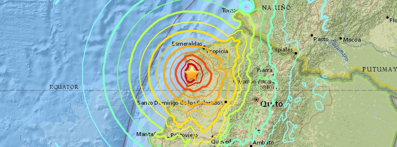
Image credit: USGS
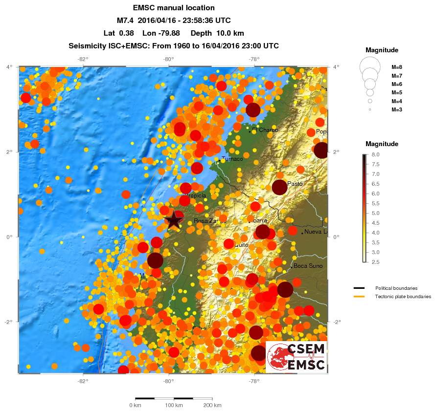
A very strong and shallow earthquake registered by the USGS as M7.8 (upgraded from M7.4) hit Ecuador at 23:58 (18:58 local time) on April 16, 2016. The agency is reporting a depth of 19.2 km (11.9 miles). EMSC is reporting M7.8 at a depth of 20 km (12.4 miles).
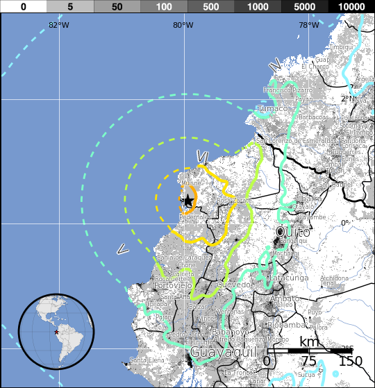
According to the USGS, the epicenter was located 27 km (16.8 miles) SSE of Muisne, 52 km (32.3 miles) W of Rosa Zarate, 68 km (42.3 miles) SSW of Propicia, 111 km (69 miles) NW of Santo Domingo de los Colorados, Ecuador and 170 km (105.6 miles) WNW of Quito, Ecuador.
There are about 685 496 people living within 100 km (62 miles).
USGS issued an orange alert level for shaking-related fatalities. Significant casualties are likely and the disaster is potentially widespread. Past events with this alert level have required a regional or national level response.
A yellow alert was issued for economic losses. Some damage is possible. Estimated economic losses are less than 1% of GDP of Ecuador.
Based on all available data, hazardous tsunami waves are forecast for some coasts, PTWC said after magnitude upgrade.
Tsunami waves reaching 0.3 to 1 meters above the tide level are possible for some coasts of Ecuador.
Tsunami waves are forecast to be less than 0.3 meters above the tide level for the coasts of American Samoa… Antarctica… Australia… Chile… Chuuk… Colombia… Cook Islands… Costa Rica… El Salvador… Fiji… French Polynesia… Guam… Guatemala… Hawaii… Honduras… Howland And Baker… Indonesia… Japan… Jarvis Island… Kermadec Islands… Kiribati… Kosrae… Marshall Islands… Mexico… Midway Island… Nauru… New Caledonia… New Zealand… Nicaragua… Niue… Northern Marianas… Northwestern Hawaiian Islands… Palau… Palmyra Island… Panama… Papua New Guinea… Peru… Philippines… Pitcairn Islands… Pohnpei… Russia… Samoa… Solomon Islands… Taiwan… Tokelau… Tonga… Tuvalu… Vanuatu… Wake Island… Wallis And Futuna… and Yap.
Actual amplitudes at the coast may vary from forecast amplitudes due to uncertainties in the forecast and local features. In particular, maximum tsunami amplitudes on atolls will likely be much smaller than the forecast indicates.
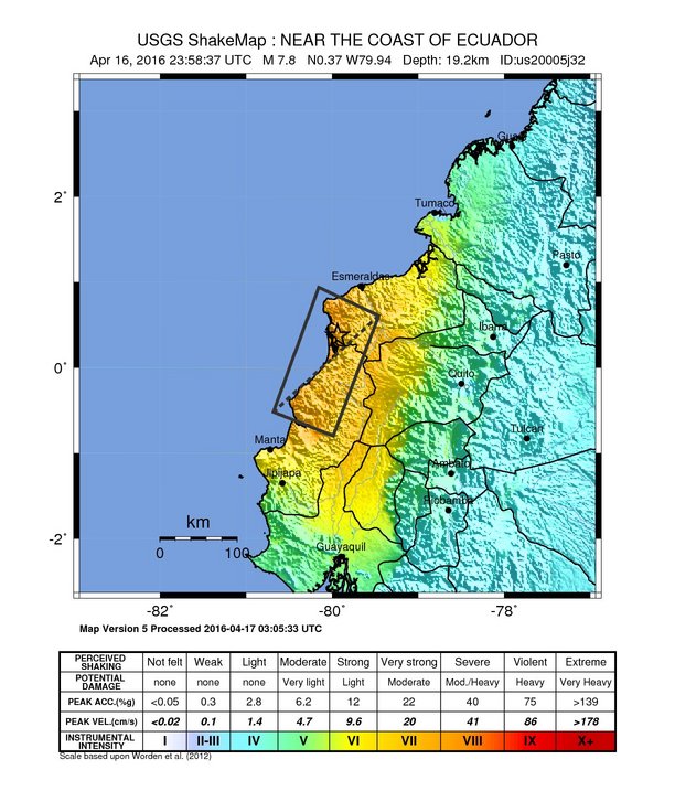
Overall, the population in this region resides in structures that are vulnerable to earthquake shaking, though some resistant structures exist. The predominant vulnerable building types are unreinforced brick masonry and mud wall construction.
Recent earthquakes in this area have caused secondary hazards such as tsunamis and landslides that might have contributed to losses.
Selected cities exposed
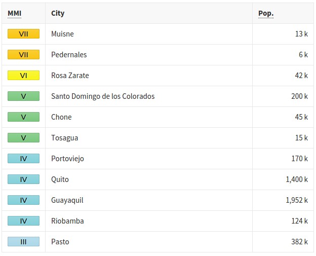
From GeoNames Database of Cities with 1,000 or more residents (k = x1,000)
Estimated population exposure to earthquake shaking
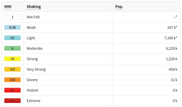
*Estimated exposure only includes population within map area (k = x1,000)
Modified Mercalli Intensity (MMI) scale
The earthquake occurred as the result of shallow thrust faulting on or near the plate boundary between the Nazca and Pacific plates. At the location of the earthquake, the Nazca plate subducts eastward beneath the South America plate at a velocity of 61 mm/yr. The location and mechanism of the earthquake are consistent with slip on the primary plate boundary interface, or megathrust, between these two major plates. Subduction along the Ecuador Trench to the west of Ecuador, and the Peru-Chile Trench further south, has led to uplift of the Andes mountain range and has produced some of the largest earthquakes in the world, including the largest earthquake on record, the 1960 M9.5 earthquake in southern Chile.
While commonly plotted as points on maps, earthquakes of this size are more appropriately described as slip over a larger fault area. Events of the size of the April 16, 2016 earthquake are typically about 160×60 km (99 x 37 miles) in size (length x width).
Ecuador has a history of large subduction zone related earthquakes. Seven magnitude 7 or greater earthquakes have occurred within 250 km (155 miles) of this event since 1900. On May 14, 1942, a M7.8 earthquake occurred 43 km (26.7 miles) south of this April 16th, 2016 event. On January 31, 1906 a M8.3 earthquake (reportedly as large as M8.8 in some sources) nucleated on the subduction zone interface 90 km to 5the northeast of the April 2016 event, and ruptured over a length of approximately 400 – 500 km (248 – 310 miles), resulting in a damaging tsunami that caused in the region of 500 – 1 500 fatalities. The April 2016 earthquake is at the southern end of the approximate rupture area of the 1906 event. A shallow, upper crustal M 7.2 earthquake 240 km (149 miles) east of the April 2016 event on March 6, 1987 resulted in approximately 1 000 fatalities.
Updates
April 17, 01:16 UTC
Damage reports are coming in:
Caída del puente en Av las Américas frente a universidad laica Vicente rocafuerte #Ecuador #terremoto pic.twitter.com/Jygs8SiAJ2
— El Tuitero Sísmico (@dngonzalo) April 17, 2016
[MUNDO] Estos son algunos daños en centros comerciales y supermercados de #Ecuador por el temblor. Vía: EU pic.twitter.com/IjACfe7s8e
— Publinews Guatemala (@PublinewsGT) April 17, 2016
Primeras imágenes de los daños producido por el fuerte sismo en #Ecuador, se reportan heridos. pic.twitter.com/EUcTLL6V8k
— EarthQuakesTime (@EarthQuakesTime) April 17, 2016
It is currently 20:16 in Ecuador (UTC -5 hrs)
01:43 UTC
Local media reported that at least one house and an overpass had collapsed in Ecuador's most populous city, Guayaquil, about 280 km (174 miles) from quake's epicenter.
In the capital, Quito (170 km / 105 miles) from the epicenter, the quake was felt for about 40 seconds and people fled buildings to the streets in fear, AP reported. The quake appeared to have knocked out electricity and cell phone coverage in several neighborhoods in the capital.
01:55 UTC
A tower at an airport in the coastal city in Manta has reportedly toppled over. The Eloy Alfaro de Manta airport has been closed due to the quake, according to local media.
06:44 UTC
There are reports of collapsed buildings in Quito and Guayaquil.
Llega a 41 número de muertos por #EcuadorEarthquake #TerremotoEcuador https://t.co/AJUtAOVScL pic.twitter.com/tEYjREbvZP
— HispanTV (@Hispantv) April 17, 2016
07:31 UTC
At least 77 people were killed and 558 injured, Vice President Jorge Glas of Ecuador said.
Ecuador has introduced a state of national emergency in six provinces: Esmeraldas, Manabí, Santa Elena, Guayas, Santo Domingo and Los Ríos, Glas said.
08:47 UTC
"Most people are out in the streets with backpacks on, heading for higher ground," said Ramon Solorzano from the town of Manta. "The streets are cracked. The power is out and phones are down."
At least 6 multi-storey buildings have collapsed in Guyaquil.
The following video shows collapsed bridge at Avenida de las Americas in Guayaquil:
08:55 UTC
USGS registered 9 earthquakes, including massive M7.8:
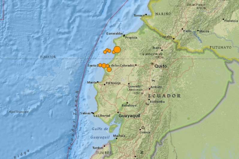
Image credit: USGS
- 5.62016-04-17 07:13:58 UTC10.0 km
- 4.52016-04-17 05:42:51 UTC10.0 km
- 4.82016-04-17 04:02:08 UTC10.0 km
- 4.52016-04-17 03:05:33 UTC10.0 km
- 4.82016-04-17 02:18:01 UTC10.0 km
- 4.52016-04-17 00:59:07 UTC27.3 km
- 5.42016-04-17 00:29:32 UTC14.2 km
- 7.82016-04-16 23:58:37 UTC19.2 km
- 4.82016-04-16 23:47:44 UTC33.0 km
12:23 UTC
According to RT Spanish, at least 142 people have been killed and 588 injured. This number is not official.
269 buildings of different sizes have collapsed.
Llegan primeros reportes de daños vía Portoviejo Pedernales #SismoEcuador pic.twitter.com/kWjFVDEsA5
— Biess-Banco del IESS (@BiessEcuador) April 17, 2016
#AHORA Con la luz del día se comienza a divisar la magnitud del terremoto en Pedernales #SismoEcuador pic.twitter.com/JdQOaJOMEG
— Andrews Abreu (@AndrewsAbreu) April 17, 2016
12:23 UTC
Rescue operations in Manta, a coastal city in the province of Manabi:
15:52 UTC
The death toll has risen to 233 people, country’s President, Rafael Correa, said. "The most affected city is Manta (suburb Tarqui). Pedernales is almost completely destroyed. The whole country is mobilized," Correa added.
Video below shows the shaking in Portoviejo:
IMPRESIONANTE asi se movio la tierra en #portoviejo #SismoEcuador #ecuador #temblorecuador @ronaldcordova pic.twitter.com/aUvttSCr28
— J. C. R. (@jctv99) April 17, 2016
April 18, 08:48 UTC
As of early Monday morning (UTC), April 18, 272 people have been killed, President Rafael Correa announced. 2 527 have been registered as injured. Apart from the fatalities and injured people, a lot of people are still missing.
April 19, 11:47 UTC
At least 413 people are now known to have died in the earthquake that struck Ecuador, the country's government said.
April 20, 09:30 UTC
Ecuador's National Prosecutors Office says the death toll has risen to 525. The office said that there were at least 11 foreigners among the dead.
April 23, 16:09 UTC
The death toll has reached 602, 130 are missing.
April 25, 12:44 UTC
The number of casualties has increased to 643.
25 376 people are homeless, 4 430 buildings were destroyed and 2 740 damaged. 281 schools have been affected.
Seismotectonics of South America (Nazca Plate Region)
The South American arc extends over 7,000 km, from the Chilean margin triple junction offshore of southern Chile to its intersection with the Panama fracture zone, offshore of the southern coast of Panama in Central America. It marks the plate boundary between the subducting Nazca plate and the South America plate, where the oceanic crust and lithosphere of the Nazca plate begin their descent into the mantle beneath South America. The convergence associated with this subduction process is responsible for the uplift of the Andes Mountains, and for the active volcanic chain present along much of this deformation front. Relative to a fixed South America plate, the Nazca plate moves slightly north of eastwards at a rate varying from approximately 80 mm/yr in the south to approximately 65 mm/yr in the north. Although the rate of subduction varies little along the entire arc, there are complex changes in the geologic processes along the subduction zone that dramatically influence volcanic activity, crustal deformation, earthquake generation and occurrence all along the western edge of South America.
Most of the large earthquakes in South America are constrained to shallow depths of 0 to 70 km resulting from both crustal and interplate deformation. Crustal earthquakes result from deformation and mountain building in the overriding South America plate and generate earthquakes as deep as approximately 50 km. Interplate earthquakes occur due to slip along the dipping interface between the Nazca and the South American plates. Interplate earthquakes in this region are frequent and often large, and occur between the depths of approximately 10 and 60 km. Since 1900, numerous magnitude 8 or larger earthquakes have occurred on this subduction zone interface that were followed by devastating tsunamis, including the 1960 M9.5 earthquake in southern Chile, the largest instrumentally recorded earthquake in the world. Other notable shallow tsunami-generating earthquakes include the 1906 M8.5 earthquake near Esmeraldas, Ecuador, the 1922 M8.5 earthquake near Coquimbo, Chile, the 2001 M8.4 Arequipa, Peru earthquake, the 2007 M8.0 earthquake near Pisco, Peru, and the 2010 M8.8 Maule, Chile earthquake located just north of the 1960 event.
Large intermediate-depth earthquakes (those occurring between depths of approximately 70 and 300 km) are relatively limited in size and spatial extent in South America, and occur within the Nazca plate as a result of internal deformation within the subducting plate. These earthquakes generally cluster beneath northern Chile and southwestern Bolivia, and to a lesser extent beneath northern Peru and southern Ecuador, with depths between 110 and 130 km. Most of these earthquakes occur adjacent to the bend in the coastline between Peru and Chile. The most recent large intermediate-depth earthquake in this region was the 2005 M7.8 Tarapaca, Chile earthquake.
Earthquakes can also be generated to depths greater than 600 km as a result of continued internal deformation of the subducting Nazca plate. Deep-focus earthquakes in South America are not observed from a depth range of approximately 300 to 500 km. Instead, deep earthquakes in this region occur at depths of 500 to 650 km and are concentrated into two zones: one that runs beneath the Peru-Brazil border and another that extends from central Bolivia to central Argentina. These earthquakes generally do not exhibit large magnitudes. An exception to this was the 1994 Bolivian earthquake in northwestern Bolivia. This M8.2 earthquake occurred at a depth of 631 km, which was until recently the largest deep-focus earthquake instrumentally recorded (superseded in May 2013 by a M8.3 earthquake 610 km beneath the Sea of Okhotsk, Russia), and was felt widely throughout South and North America.
Subduction of the Nazca plate is geometrically complex and impacts the geology and seismicity of the western edge of South America. The intermediate-depth regions of the subducting Nazca plate can be segmented into five sections based on their angle of subduction beneath the South America plate. Three segments are characterized by steeply dipping subduction; the other two by near-horizontal subduction. The Nazca plate beneath northern Ecuador, southern Peru to northern Chile, and southern Chile descend into the mantle at angles of 25° to 30°. In contrast, the slab beneath southern Ecuador to central Peru, and under central Chile, is subducting at a shallow angle of approximately 10° or less. In these regions of “flat-slab” subduction, the Nazca plate moves horizontally for several hundred kilometers before continuing its descent into the mantle, and is shadowed by an extended zone of crustal seismicity in the overlying South America plate. Although the South America plate exhibits a chain of active volcanism resulting from the subduction and partial melting of the Nazca oceanic lithosphere along most of the arc, these regions of inferred shallow subduction correlate with an absence of volcanic activity. (USGS) More information on regional seismicity and tectonics
I'm a dedicated researcher, journalist, and editor at The Watchers. With over 20 years of experience in the media industry, I specialize in hard science news, focusing on extreme weather, seismic and volcanic activity, space weather, and astronomy, including near-Earth objects and planetary defense strategies. You can reach me at teo /at/ watchers.news.
Philippine
Earth directed CME’s are the cause. The greater earth changes occur during that highest sunspot activity. What causes the sunspots? Man’s ‘attitude’/behavior towards one another. Because it’s not that the planets have the greater influence upon mankind, but rather it;s the other way around, mankind has the greater influence upon the planets and thus why we’re seeing planetary chaos and not just within the earth, they are all being affected.
Is there something causing the increase in earthquakes? Is planet x causing this?
No.