At least 7 killed, 2.2 million without power as severe thunderstorms hit Houston, Texas
At least 7 people were killed and about 2.2 million people lost power as intense thunderstorms swept through Texas on May 16, 2024. The storms brought heavy rain, destructive winds, and dangerous flooding to already inundated areas.
Intense thunderstorms swept through Texas on Thursday, May 16, bringing heavy rain, destructive winds, and dangerous flooding, particularly in the already inundated Southeast Texas.
The severe weather event left four people dead and resulted in approximately 2.2 million residents across the state without power — most of them from the Houston area.
Houston Mayor John Whitmire confirmed 4 fatalities during a news briefing on Thursday night while Fire Chief Samuel Peña reported that at least two individuals were killed by falling trees and one person died in an accident involving a crane toppled by the strong winds. On Friday, officials were still determining the final numbers but ABC13 is reporting 7 fatalities associated with the storm.
“We have a storm with 160 km/h (100 mph) winds, the equivalent of Hurricane Ike, causing considerable damage downtown,” Whitmire stated.
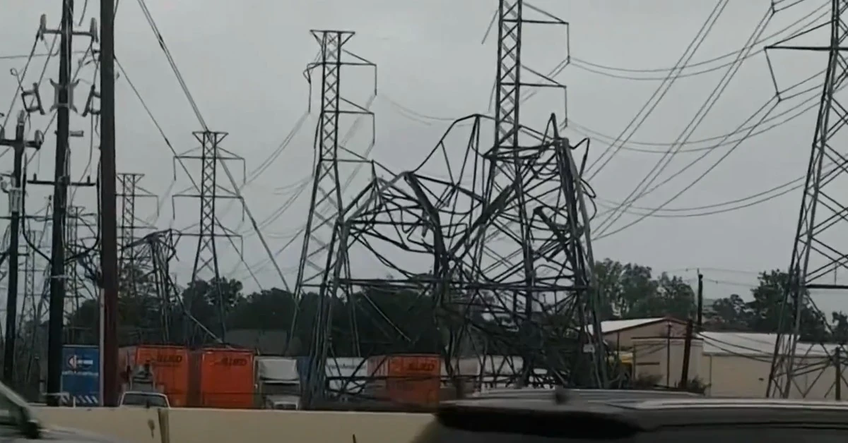
Damage reports from downtown Houston include blown-out windows, twisted metal signposts, a collapsed office building wall, and downed power lines.
The public school district in Houston announced the closure of all schools on Friday while emergency responders urged residents to stay home due to numerous downed traffic lights and live power lines obstructing major highways.
Mayor Whitmire indicated that power restoration efforts could take between 24 to 48 hours in some parts of the city.
Damaging severe storms slammed Houston this evening.
— CIRA (@CIRA_CSU) May 17, 2024
This view shows the lightning-packed storms from above. pic.twitter.com/i97DcSMVIb
Video from @lieggiji of glass covering downtown Houston from blown out windows after our powerful storm. #abc13 #Houston pic.twitter.com/hEOauXG1H4
— Pooja Lodhia (@PoojaOnTV) May 17, 2024
#BREAKING: Nearly a Million are without Power as Powerful Storms Move through with 80-117 mph Winds Toppling large transmission power lines and Shattering skyscrapers Windows
— R A W S A L E R T S (@rawsalerts) May 17, 2024
#Houston | #Texas
Currently nearly 935,000 customers in Houston Texas are without power with the… pic.twitter.com/LiSbmRhiib
Beware of downed trees and downed power lines. Both are a threat to your safety. @houmayor Whitmire is working with @HoustonOEM and first responders to do citywide damage assessments. Please do your best to stay off the roads tonight, many are impossible, and some traffic signals… pic.twitter.com/cIMfhKmF8q
— City of Houston (@HoustonTX) May 17, 2024
The National Weather Service in Houston issued tornado, flash flood and severe thunderstorm warnings for multiple counties as the storm approached. Residents were advised to seek shelter and move to the lowest floors of their buildings.
Eastwood, a neighborhood in Houston’s East End, was particularly hard hit. Trees crashed through roofs and fences, blocking streets and causing significant property damage. As the storm subsided, residents began the cleanup process, using chainsaws, axes, and rakes to clear debris.
Harris County Judge Lina Hidalgo announced that the county’s precincts and engineering department would work overnight to clear roadway debris. She also mentioned that 480 000 customers in her region were still without power, with residents on the county’s west side and around Cypress facing longer restoration times due to downed transmission towers.
“There are 1 500 mutual assistance crews currently traveling to our area to help restore power to residents who are not dependent on the transmission lines,” Hidalgo stated. She emphasized that the county’s focus was on clearing major thoroughfares to facilitate CenterPoint’s restoration efforts. The county warned that ongoing damage assessments made it unclear when all roadways would be cleared and advised residents to treat downed traffic lights as four-way stop signs.
As of 02:25 CDT (07:25 UTC) on May 16, a total of 1 087 816 customers were without power across several states. In Texas, 863 008 customers experienced outages. Louisiana had 197 480 customers without power, Mississippi reported 14 042 outages, and North Carolina had 13 286 customers affected by the power disruptions.
Assuming an average household size of 2.6 people per customer (based on U.S. Census data), this outage likely impacted approximately 2.8 million people in total. Specifically, around 2.2 million people in Texas, 513 000 in Louisiana, 36 000 in Mississippi, and 34 000 in North Carolina.
This is the second severe weather event to hit Southeast Texas this month.
Earlier in May, the region experienced severe flooding due to heavy rains, which led to the overflowing of rivers such as the Trinity and San Jacinto.
Areas near Trinity recorded between 150 mm and 230 mm (6 to 9 inches) of rainfall, while Groveton in Trinity County received nearly 280 mm (11 inches) of rain from April 28 to May 2. The northern part of Harris County reported 250 mm to 300 mm (10 to 12 inches) of rainfall within 24 hours. The Navasota River near Easterly set a historic peak at 30.62 m (100.43 feet), the highest recorded since June 1, 1899.
The flooding prompted both voluntary and mandatory evacuations in various communities, especially those along the Trinity and San Jacinto rivers.
More excessive rainfall and severe thunderstorms threaten the southern U.S.
“The main weather story today remains the dangerous and life-threatening flash flood potential over the Lower Mississippi Valley into the overnight hours as widespread thunderstorms batter areas which are very vulnerable to additional rainfall, NWS forecaster Asherman said at 14:30 CDT (19:30 UTC) on May 16.
“Going into the evening and overnight hours, repeating of these thunderstorms containing very heavy rainfall rates within the complex will lead to rainfall amounts of 125 – 200 mm (5 – 8 inches) within the High Risk area over eastern Texas and western Louisiana before the thunderstorms migrate eastward by tomorrow morning [Friday, LT].
“Remember, High Risks for Excessive Rainfall are a BIG DEAL: 1/3 flood-related fatalities and 4/5 flood-related damages occur in WPC High Risks, so pay attention to the latest warning information and NEVER drive or walk into floodwaters.
By Friday morning, May 17, the threat of significant flash flooding will spread east into southern Mississippi and western Alabama as a warm front stalls out over the Southeast.
“A very moist and unstable atmosphere appears primed to support bouts of prolific heavy rainfall, with multiple rounds of storms expected as multiple disturbances aloft traverse the area,” Asherman said.
When combined with saturated soils from recent heavy rainfall, a Moderate Risk (level 3/4) is in effect tomorrow with areal rainfall amounts upwards of 50 – 125 m (2 – 5 inches) — (locally up to 178 mm (7 inches) possible.
The same warm front driving the thunderstorms will also contribute to sweltering heat in South Florida and Texas.
Recent experimental NWS HeatRisk guidance continues to suggest moderate to locally major heat-related impacts will continue across these areas at least through Saturday due to the combination of heat indices eclipsing 38 °C (100 °F), with little overnight relief expected.
Updates
06:08 UTC, May 18
In a press conference on Friday morning, Hidalgo said some areas will be without power for weeks.
“Many high-rise skyscraper windows were shattered in parts of the Houston downtown area given that distributive winds near the ground were even higher just above the ground as there is less friction from buildings and trees, etc. to slow the winds just above the ground,” AccuWeather Chief Meteorologist Jon Porter said.
On Saturday, May 18, isolated to scattered severe thunderstorms appear possible across portions of the Southeast and Carolinas where a Slight Risk (Level 2 of 5) has been issued. A Slight Risk Excessive Rainfall Outlook (Level 2 of 4) has been issued for part of the northern Gulf Coast Saturday due to the threat of flash, urban, and riverine flooding.
Preliminary survey reports by NWS mention an EF1 tornado near Cypress (with peak winds 178 km/h / 110 mph); straight-line wind damage in downtown Houston (winds peaked ~160 km/h / 100 mph); and widespread straight-line winds near Baytown/Galena Park area with winds peaking between 145 and 160 km/h (90 – 100 mph).
References:
1 Deadly storms slam Houston yet again as nearly 1 million customers without power in Texas – CBS – May 17, 2024
2 Short Range Forecast Discussion – NWS WPC – 350 PM EDT Thu May 16 2024
Featured image: Damaged power lines in Houston after severe storm on May 16, 2024. Credit: KTVB (stillshot)
Commenting rules and guidelines
We value the thoughts and opinions of our readers and welcome healthy discussions on our website. In order to maintain a respectful and positive community, we ask that all commenters follow these rules.