Tropical Cyclone “Hidaya” heading toward Tanzania and Kenya
Tropical Cyclone “Hidaya” formed on May 1, 2024, north of Madagascar, Comoros, and Mayotte as the 9th named storm of the 2024/24 South-West Indian Ocean cyclone season. The cyclone peaked around 00:00 UTC on May 3 at 148 km/h (92 mph) but is now starting to come down, albeit slowly. Widespread heavy rainfall is forecast in Tanzania, starting this evening, May 3, and continuing until Sunday morning, May 5. Severe flooding is likely across Tanzania and neighboring Kenya.
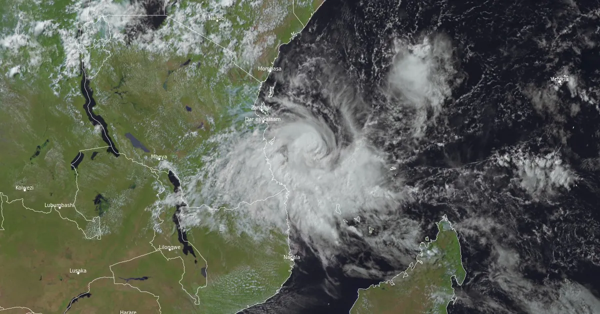
At 12:00 UTC, the center of Hidaya was located about 320 km (200 miles) ESE of Dar es Salaam, capital of Tanzania. The cyclone was moving WNW at a speed of 13 km/h (8 mph). Hidaya’s maximum average wind speed (10 minutes) was 120 km/h (75 mph) while the central pressure was 981 hPa.
Both Tanzania and Kenya have experienced excessive rainfall and devastating floods over the past weeks, resulting in nearly 400 fatalities. Any new rainfall is likely to cause further flooding.
In preparation, the Kenyan government has ordered a mandatory evacuation for residents near 178 dams and water reservoirs in 33 counties. The country has seen massive destruction since March, with at least 210 fatalities and 90 people still missing. More than 165 000 have been displaced, as of May 3.
A statement issued by the Tanzania Meteorological Authority (TMA) on Thursday, May 2, said the cyclone is expected to cause heavy rain and strong winds in some regions, including Mtwara, Lindi, and Coast (including the Mafia Islands), Dar es Salaam, Tanga, Morogoro, Ugunja, and Pemba regions and neighboring areas.
TMA urged civilians to continue monitoring weather forecasts and heed precautionary information.
Over the past 6 hours, Hidaya’s eye pattern has become less defined, particularly after 09:00 UTC, despite convection remaining very intense near the system’s tight center, according to the bulletin issued by RSMC La Reunion at 13:00 UTC.
The 07:52 UTC GMI microwave image showed a slight degradation of the cyclone’s structure, with a more open convective core and a mid-tropospheric vortex tilted 16 to 24 km (10 to 15 miles) south of the low-level center, indicative of the first effects of increasing northerly mid-level shear.
Satcon and DMINT/DPRINT estimates suggest a slight decrease in intensity compared with 06:00 UTC. These elements made La Reunion forecasters estimate the system’s intensity at 120 km/h (75 mph) at 12:00 UTC.
Until Saturday morning, May 4, the system’s movement will remain driven by the subtropical ridge over southeastern Africa, inducing a west-north-westward motion. From Saturday onwards, the steering flow will shift down into the mid-troposphere, then into the low troposphere on Saturday evening as the system weakens, which should make the track turn to the north-west and then north-northeast in the immediate vicinity of the Tanzanian coast.
“A landfall cannot be completely ruled out, even if the favored scenario keeps the center slightly offshore. This will have to be confirmed by tomorrow,” RSMC La Reunion said.
In terms of intensity, the northerly to northeasterly wind shear is expected to increase from this evening and increasingly affect the integrity of the system’s vortex.
Hidaya could therefore weaken more rapidly tonight and tomorrow. However, it could still be at moderate tropical storm stage on Saturday as it approaches the Tanzanian coast, before filling in and dissipating definitively during Saturday night or Sunday morning at the latest.

Expected impacts over the next 48 hours
Tanzania
- Heavy rainfall starting this evening and continuing until Sunday morning. Widespread accumulations of 100 to 200 mm (3.9 to 7.9 inches) in less than 48 hours over the central and southern coastal areas (between Dar es Salaam and Mtwara), locally up to around 300 mm (11.8 inches). Severe flooding is likely. Improving from Sunday afternoon onwards.
- Gales likely on Saturday locally along coastal parts of Pwani Region, including Mafia Island.
- Very rough seas, waves of 4 to 6 m (13 to 20 feet) from this evening, especially on Mafia Island. Improving on Saturday evening.
Mozambique (Cabo Delgado Province)
- Heavy rainfall has started this Friday evening and will persist until tomorrow. Total rainfall of 100 to 150 mm (3.9 to 5.9 inches) over 24 to 48 hours in the extreme northeast of the province. Improving on Saturday evening.

JTWC forecast
JTWC’s forecast issued at 15:00 UTC today also showed significant changes from the previous.
Their previous forecast called for continued intensification, but this forecast predicts the opposite, resulting in a substantial change in the forecast intensity, particularly in the first 12 to 24 hours.
According to JTWC, Hidaya is expected to maintain WNW motion through the next 24 hours, approaching a landfall along the coast of Tanzania south of Dar es Salaam by 15:00 UTC on May 4.
As the system weakens rapidly, the steering flow becomes progressively shallower, where the ridge is oriented more north-south. The net effect will be for the system to turn more equatorward as it weakens.
Their current forecast calls for the system to track very close to Dar es Salaam and then remain inland as it dissipates.
A faster rate of weakening could result in the system turning more sharply northward and tracking back out over water as it dissipates, as suggested by some of the model guidance.
In terms of intensity, the system peaked around 00:00 UTC on May 3 at 148 km/h (92 mph) but is now starting to come down, albeit slowly as it is just beginning to feel the effects of increasing shear and dry air entrainment. Shear is expected to rapidly increase over the next 12 to 24 hours, which will quickly erode the vortex, as well as usher in additional dry air. Add in the disruption of the low-level inflow due to frictional effects as the system approaches land, and the system will rapidly weaken from here forward.
Dissipation over or just along the east coast of Tanzania is forecast by 15:00 UTC on May 5, if not a bit earlier.
The deterministic models currently display a wide range of possible paths for the system. Models like the GFS, NAVGEM, and most mesoscale models predict a nearly due west trajectory throughout the forecast period.
In contrast, models such as the UKMET, GALWEM, and GFS ensemble suggest a more equatorward turn after 03:00 UTC on May 4, potentially keeping the system over water for most of the forecast duration.
The ECMWF model aligns closely with the average forecast, similar to the JTWC forecast, which places it on the southwestern periphery of the northern group of models.
References:
1 TROPICAL CYCLONE 10 (HIDAYA) – RSMC La Reunion bulletin issued 13:00 UTC on May 3, 2024
2 Tropical Cyclone 23S (Hidaya) Warning #05 – JTWC – Issued at 03/1500Z
3 Tanzania Meteorological Authority urges precaution as Cyclone Hidaya intensifies – The East African – May 3, 2024
4 Kenya, Tanzania brace for Cyclone Hidaya as flood death toll rises – Al Jazeera – May 3, 2024
Featured image: Tropical Cyclone “Hidaya” at 12:00 UTC on May 3, 2024. Credit: EUMETSAT/Meteosat-9, RAMMB/CIRA, The Watchers
Commenting rules and guidelines
We value the thoughts and opinions of our readers and welcome healthy discussions on our website. In order to maintain a respectful and positive community, we ask that all commenters follow these rules.