
Major eruption at Merapi volcano produces very large pyroclastic flow, Indonesia
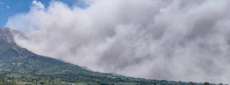
Image credit: BPPTKG
A powerful eruption took place at Indonesia’s Merapi volcano at 05:12 UTC on March 11, 2023, producing massive pyroclastic flow near populated areas and blanketing nearby villages in ash. There were no immediate reports of casualties. The Alert Level remains at 3 (on a scale of 1-4), and the public is warned to stay 3 – 7 km (1.8 – 4.3 miles) away from the summit based on location.
The eruption produced a very large pyroclastic flow (PDC) that traveled through the Bebeng/Krasak ravine on the southeastern flank and reached an estimated distance of 7 km (4.3 miles) from the summit.
At least eight villages near the volcano have been affected by volcanic ash, an officer at one of Merapi’s observation posts said in a statement.
A series of additional pyroclastic flows were observed through the rest of the day, with some of them reaching distances of up to 2 km (1.2 miles).
Intense eruptive activity continued into March 12 and 13, with additional PDCs reaching distances of up to 4 km (2.5 miles) and ash rising up to 6 km (20 000 feet) above sea level.
“To anticipate potential danger from Mount Merapi eruption, the public is advised to stop any activities in the potential danger area,” the Director of Risk Mapping and Evaluation of the National Agency for Disaster Management (BNPB), Abdul Muhari, said in a statement.
The current hazard potential is in the form of lava avalanches and PDCs in the south-southwest sector including the Boyong River for a maximum distance of 5 km (3.1 miles), and the Bedog River, Krasak, Bebeng for a maximum distance of 7 km (4.3 miles). In the southeastern sector, it includes the Woro River for a maximum of 3 km (1.8 miles) and the Gendol River for 5 km (3.1 miles).
A major eruption at Merapi in 2010 (VEI 4) killed 347 people and forced 280 000 residents to evacuate. It was the strongest eruption since 1930 when 1 300 people died. Another significant eruption occurred in 1994, resulting in around 60 fatalities.
Geological summary
Merapi, one of Indonesia’s most active volcanoes, lies in one of the world’s most densely populated areas and dominates the landscape immediately north of the major city of Yogyakarta. It is the youngest and southernmost of a volcanic chain extending NNW to the Ungaran volcano.
Growth of Old Merapi during the Pleistocene ended with major edifice collapse perhaps about 2 000 years ago, leaving a large arcuate scarp cutting the eroded older Batulawang volcano.
Subsequently, the growth of the steep-sided Young Merapi edifice, its upper part unvegetated due to frequent eruptive activity, began SW of the earlier collapse scarp.
Pyroclastic flows and lahars accompanying growth and collapse of the steep-sided active summit lava dome have devastated cultivated lands on the western-to-southern flanks and caused many fatalities during historical time.2
References:
1 Merapi volcano erupts, covers villages in ash – The Jakarta Post – March 13, 2023
2 Merapi – Geological summary – GVP
I'm a dedicated researcher, journalist, and editor at The Watchers. With over 20 years of experience in the media industry, I specialize in hard science news, focusing on extreme weather, seismic and volcanic activity, space weather, and astronomy, including near-Earth objects and planetary defense strategies. You can reach me at teo /at/ watchers.news.
Commenting rules and guidelines
We value the thoughts and opinions of our readers and welcome healthy discussions on our website. In order to maintain a respectful and positive community, we ask that all commenters follow these rules.