
Six underwater volcanoes discovered near Sicily, Mediterranean Sea
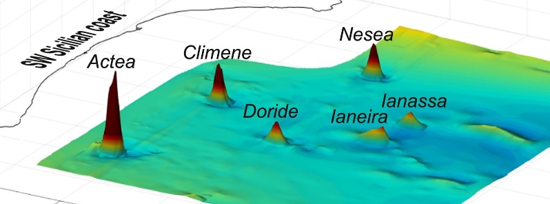
Featured image: Reduced-to-the-pole, 3-D magnetic anomaly map of the study area, showing the occurrence of localized and circumscribed magnetic anomaly peaks at the identified volcanoes. Credit: Authors, Elsevier
Scientists have discovered a series of previously unknown volcanoes just off the coast of SW Sicily, Italy. The three northern volcanoes show a tuff cone-like morphology while the three most southern edifices have a truncated-conical shape. Ages of all newly discovered volcanoes are Late Quaternary. Only the northernmost volcano shows indications of a post-Last Glacial Maximum magmatic reactivation.
The Graham and Terrible banks, located about 35 km (21 miles) from the south-western coast of Sicily, host a large number of volcanic constructs, the most famous being the ephemeral Ferdinandea Island, authors said in the abstract of the new study, published recently in Elsevier's Marine Geology.
These volcanoes occur along two N-S trending strike-slip lineaments that constitute the lithospheric-scale Capo Granitola-Sciacca Fault Zone.

(A) General physiographic map of the Sicilian Channel. Bathymetry derived from EMODnet Digital Terrain Model (1/16*1/16 arc minutes), and extracted from the following link: http://www.emodnet-bathymetry.eu/. Abbreviations: GB, Graham Bank; TB, Terrible Bank; NB, Nerita Bank; NaB, Nameless Bank; SMTF, Sicilian-Maghrebian Chain Frontal Thrust. Black rectangle indicates the study area. The dotted black segments indicate the position of the main tectonic lineaments associated with the Capo Granitola and Sciacca fault system (adapted from Civile et al., 2018). Box in the upper-right corner locates the Sicilian Channel within the central Mediterranean Sea. Abbreviations: SMC, Sicilian-Maghrebian Chain; CGSFZ, Capo Granitola-Sciacca Fault Zone. (B) Shaded-relief swath bathymetric map (Multibeam) of the study area off the SW coast of Sicily, superposed onto the EMODnet Digital Terrain Model to fill the areas not covered by the multibeam measurements. The six volcanic edifices described in this study are labelled. Black dotted segments indicate the corresponding figures (seismic profiles). Thin white lines are the faults associated with the two strike-slip fault systems identified in the study area (from Civile et al., 2018): the Capo Granitola Fault System (CGFS) and the Sciacca Fault System (SFS). The positions of the available exploration wells, made available by the project “Visibility of Petroleum Exploration Data in Italy” (ViDEPI, http://www.videpi.com), are also shown. Credit: Authors
In the study, the researches presented recently acquired swath bathymetric data and magnetic measurements, in conjunction with high-resolution seismic profiles, which reveal the presence of another six volcanic edifices located very close to the Sicilian coasts, one of which is only 7 km (4.3 miles) away.
3 of these volcanic constructs have been previously identified only on the basis of available seismic profiles, but their morphology and their volcanic nature had so far not been documented. 2 edifices to the north show a possible tuff cone/ring-like morphology modified by crater breaching, while the three southernmost volcanoes have a truncated-conical shape.
The northwestern-most volcano (here called Actea) shows a more complex morphology, probably representing the remnants of a previous crater rim.
Seismic data analysis suggests that the six volcanic edifices were generated during a pre-Last Glacial Maximum (ca. 20 000 B.P.) magmatic phase associated with a tectonic event.
Only the Actea volcano shows indications of magmatic reactivation, possibly between the LGM and the initial post-LGM transgressive phase. This reactivation is evident by the emplacement of a prominent young lava flow.
The discovery of submerged volcanoes so close to the populated coast of Sicily demonstrates that there are large submerged areas near the littoral that are still little known and studied, and underlines how crucial it is to analyze the issue of volcanic risk for densely inhabited coastal areas like Sicily.
Reference:
"A series of volcanic edifices discovered a few kilometers off the coast of SW Sicily" – Emanuele Lodolo, Dario Civile, Massimo Zecchin, Luigi Sante Zampa, Flavio Accaino – https://doi.org/10.1016/j.margeo.2019.105999
I'm a dedicated researcher, journalist, and editor at The Watchers. With over 20 years of experience in the media industry, I specialize in hard science news, focusing on extreme weather, seismic and volcanic activity, space weather, and astronomy, including near-Earth objects and planetary defense strategies. You can reach me at teo /at/ watchers.news.
Commenting rules and guidelines
We value the thoughts and opinions of our readers and welcome healthy discussions on our website. In order to maintain a respectful and positive community, we ask that all commenters follow these rules.