
2018 M7.5 Sulawesi earthquake and tsunami update, the deadliest earthquake in 2018
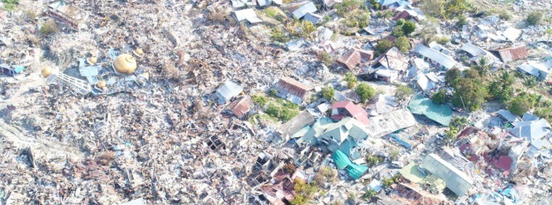
Featured image: Balaroa, a district in Palu, was completely obliterated by the soil liquefaction that followed immediately after the earthquake. Credit: Makassar Regional Disaster Mitigation Agency
Powerful M7.5 earthquake and tsunami that hit Sulawesi, Indonesia on September 28, 2018 – and the resulting land liquefaction and landslides – killed 2 101 people, CWS reported December 4, 2018. This is the deadliest earthquake to strike the country since 2006 Yogyakarta earthquake and the deadliest earthquake worldwide so far in 2018. Unofficial reports mention 2 245 people killed and 4 488 injured.
Palu was the worst-affected area with more than 1 700 casualties. Search and rescue operations there were stopped on October 12, according to Indonesia’s national disaster management agency. At least 1 075 people are still reported missing.
Roughly 133 630 people are still displaced across Central Sulawesi, CWS said. Thousands more have left the province or found refuge with host families. The government-led response continues to address humanitarian needs while progressively transitioning into the recovery and reconstruction phase.
Priority needs include: logistics and economic recovery, medical assistance, clean water, sanitation and hygiene, recovery of infrastructure and public services, shelter, protection (including women’s and children‘s protection) and education.
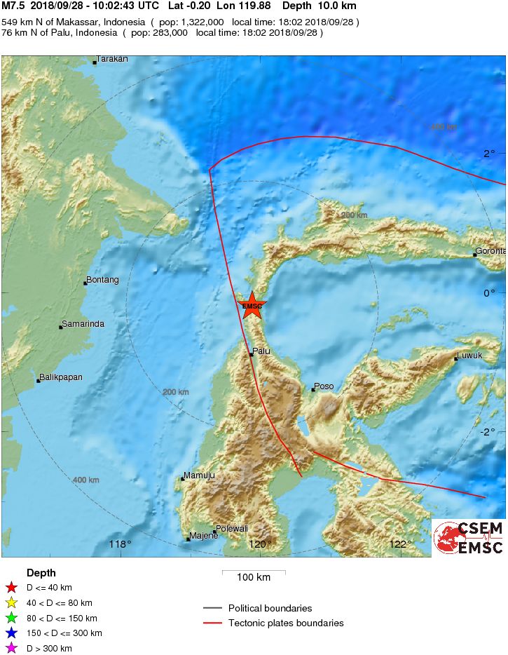
The mainshock was preceded by a sequence of foreshocks starting about three hours earlier with a M6.1 event, followed by several others, all located in the area immediately south of the mainshock epicenter. At least 1 person was killed by fallen debris while 10 others were injured during this quake. Authorities confirmed that dozens of structures were either damaged or destroyed.
The mainshock occurred at 10:02 UTC (18:02 WITA), during rush hour traffic. The shaking was felt as far away as Samarinda, the capital of East Kalimantan, to the west and Makassar in the south. It was also felt in several parts in Gorontalo, located on the north and was also felt in Tawau, Malaysia. Violent shaking was reported in Donggala and Palu. Blackouts occurred throughout the area and telecommunications went down.
More than 70 000 houses are reported to be damaged, forcing tens of thousands of people to live in shelters and tents.
A tsunami warning was issued in Palu and Donggala at 10:07 UTC (18:07 WITA). Warnings were sent via SMS by the Indonesian Ministry of Communication and Information. Residents of Donggala were told to expect tsunamis with heights of 0.5 to 3 m (1.6 to 9.8 feet), while residents in Palu were told to expect tsunamis with heights of less than 0.5 m.
The tsunami, however, struck higher than expected; one explanation is that the earthquake triggered underwater landslides, causing the tsunami. Residents of Palu reported waves with heights of more than 2 m (6.5 feet) while several others stated that the waves managed to reach the second floor.
Even though officials did send warnings via telephones and televisions, tsunami alarms were not activated. The Palu Nomoni Festival in Talise Beach was continued and most of the festival attendees didn't realize on the possibility for a tsunami to occur. Eyewitnesses even stated that some people were still strolling on the beach when the tsunami struck. It was estimated that hundreds were caught off guard and swept away by the waves.
The Indonesian Agency for Meteorology, Climatology and Geophysics (BMKG) later admitted that the tsunami detectors in Palu were damaged in the earthquake. The shaking was violent enough to damage the tsunami detectors in Palu, as further examination revealed that none of the detectors were able to send signals to alert residents.
As Palu was located at the end of a narrow bay, the tsunami's force was intensified when the waters entered. Officials confirmed that the waves that struck Palu had actually reached a height of 5 m (16 feet), with some as nearly as high as 6 m (19.6 feet).
Parts of Central Sulawesi have been hit by major mudflows following the earthquake as a result of liquefaction. The most affected areas are the Petobo sub-district in southern Palu and the village of Balaroa, just outside the city, both locations some distance from the coast.
I'm a dedicated researcher, journalist, and editor at The Watchers. With over 20 years of experience in the media industry, I specialize in hard science news, focusing on extreme weather, seismic and volcanic activity, space weather, and astronomy, including near-Earth objects and planetary defense strategies. You can reach me at teo /at/ watchers.news.
since 2006 Yogyakarta earthquake you mean.
Yes, thank you!