
Study helps explain why jet stream stalls out over regions, causing extreme weather events
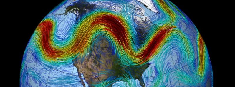
Image credit: NASSA/Goddard
A new study published recently in Science offers an explanation for a mysterious and sometimes deadly weather pattern in which the jet stream stalls out over a region. The discovery is expected to help predict long-term patterns, including which areas may see more drought or floods.
Much like highways, the global air current that circles the Earth – jet stream – has a capacity, and when it’s exceeded, blockages form that are remarkably similar to traffic jams. Using the same math, climate forecasters can now model them both, University of Chicago scientists report in a study published recently in Science.
The deadly 2003 European heat wave, California’s 2014 drought and the swing of Superstorm Sandy in 2012 that surprised forecasters – all of these were caused by a weather phenomenon known as 'blocking,' in which the jet stream meanders, stopping weather systems from moving eastward.
"Blocking is notoriously difficult to forecast, in large part because there was no compelling theory about when it forms and why," said lead author Noboru Nakamura, a professor in the Department of the Geophysical Sciences.
Nakamura and Clare S.Y. Huang, PhD'17, were studying the jet stream, trying to determine a clear set of measurements for blocking in order to better analyze the phenomenon. One of their new metrics was a term that measured the jet stream’s meander. Looking over the math, Nakamura realized that the equation was nearly identical to one devised decades ago by transportation engineers trying to describe traffic jams.
"It turns out the jet stream has a capacity for ‘weather traffic,’ just as the highway has traffic capacity, and when it is exceeded, blocking manifests as congestion," said Huang, who performed the research for her thesis.
Just as car traffic piles up where the speed limit is reduced or multiple highways converge, blocking often occurs where the background jet speed slows down due to mountains and coasts.
The result is a simple theory that not only reproduces blocking, but predicts it, said Nakamura, who called making the cross-disciplinary connection 'one of the most unexpected, but enlightening moments in my research career – it was a gift from God.'
The explanation may not immediately improve short-term weather forecasting, the researchers said, but it will certainly help predict long-term patterns, including which areas may see more drought or floods.
Reference:
"Atmospheric Blocking as a Traffic Jam in the Jet Stream" – Nakamura and Huang, Science, May 24, 2018. DOI: 10.1126/science.aat0721
I'm a dedicated researcher, journalist, and editor at The Watchers. With over 20 years of experience in the media industry, I specialize in hard science news, focusing on extreme weather, seismic and volcanic activity, space weather, and astronomy, including near-Earth objects and planetary defense strategies. You can reach me at teo /at/ watchers.news.
Nakamura credits his scientific breakthrough as a “gift from God” … Comedians, take note.
you want me to believe this when i know about geo weather engineering? weather is controlled by our govt.