
Tropical Storm “Seniang” (Jangmi) leaves a trail of destruction, Philippines
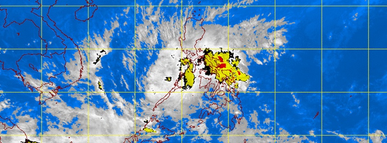
Image credit: PAGASA/MTSAT (IR1) acquired on December 30, 2014 at 09:01 UTC.
Tropical Storm "Jangmi", locally known as Seniang, made landfall near the town of San Agustin, Surigao del Sur province of northeastern Mindanao, Philippines early on December 29 (local time) and left a trail of destruction as it moved across the central part of the country.
Heavy rain has accompanied this system as it moved onshore, with 162 mm (6.3”) of rainfall reported in the town of Surigao, and Hinatuan picking up a colossal 362 mm (14.2”), meteorologist Robert Speta of the WestPacWx said.
According to latest reports, heavy flooding and landslides that followed caused deaths of at least 11 people.
TOP STORY: ‘Unprecedented’ floods in Bohol as #SeniangPH kills 11 http://t.co/wHcIhtAaCe pic.twitter.com/Crf0XLo1vG
— Rappler (@rapplerdotcom) December 30, 2014
Portion of Trans-Central Highway in Balamban, Cebu collapsed due to #SeniangPH | via @cebugovph pic.twitter.com/VKEY2qc3kq
— The Philippine Star (@PhilippineStar) December 30, 2014
Bohol is among the provinces hardest hit by floods, and is now under a state of calamity. Rivers burst their banks, covering roads and highways in knee-deep floods that washed out bridges and stalled vehicles, regional civil defense officer Allen Cabaron said, adding that floods in some areas were "neck-deep.”
Video courtesy of WestPacWx
NASA's Aqua satellite passed over Jangmi on December 29 at 05:05 UTC and saw bands of thunderstorms wrapped into the center from the northeastern and southeastern quadrants stretching back over the Philippine Sea (east of the country).
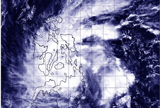
NASA's Aqua satellite captured this image of Tropical Storm Jangmi over the central and southern Philippines on December 29 at 5:05 UTC. Image credit: NASA/NRL
The Joint Typhoon Warning Center (JTWC) looked at animated enhanced infrared satellite imagery and a radar animation from Cebu Station, Philippines that showed Jangmi intensified as it tracked across the Surigao Strait. The low level circulation had become more tightly wrapped and better defined despite a weakening in the bands of thunderstorms as the system made landfall across Bohol Island.
At 06:00 UTC today, Tropical Storm "Jangmi" had maximum sustained winds of 35 knots (40.2 mph/64.8 km/h) and wind gusts of 45 knots (51 mph/83.3 km/h). Maximum significant wave height at the time was 10 feet (3 meters).
At 09:00 UTC today, the center of the storm was located approximately 140 nautical miles (161 miles/259 km) ENE of Puerto Princesa, Philippines, and has tracked WSW at 12 knots (13.8 mph/22.2 km/h) over the past six hours.
In the longer range this storm could bring the threat of rains to Malaysia, the last place on earth that needs any heavy rains at this time, Speta warns.
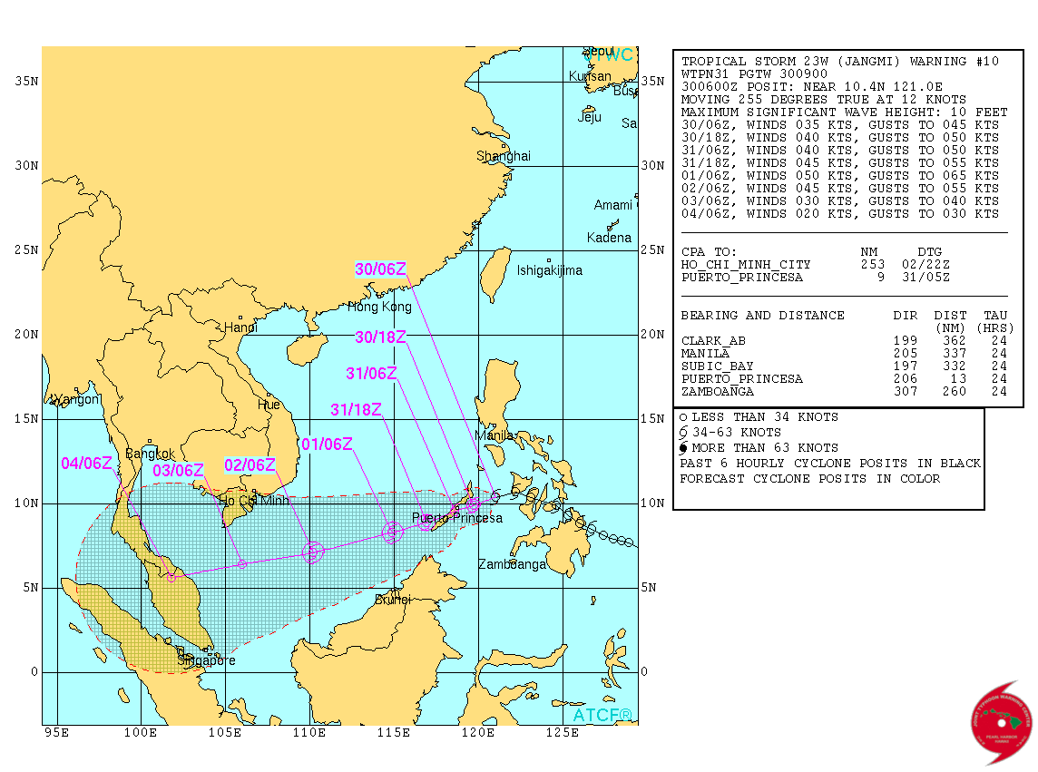
Tropical Storm "Jangmi" JTWC forecast track on December 30, 2014.
Video courtesy of WestPacWx
PAGASA's latest Tropical Cyclone Warning for TS "Seniang" (Jangmi) issued 09:00 UTC today (17:00 local time today) said estimated rainfall amount is from 7.5 – 15 mm per hour (moderate – heavy) within the 300 km diameter of the Tropical Storm.
Residents in low lying and mountainous areas of the provinces with PSWS#2 and PSWS#1 are alerted against possible flashfloods and landslides.
Ocean waves may reach up to 5 meters.
Fisherfolks and those with small seacrafts are advised not to venture out over the seaboards of Luzon, Visayas and over the northern and eastern seaboards of Mindanao.
Satellite animations
- Storm-Centered Infrared (MTSAT2; NOAA/SSD)
- Storm-Centered Infrared (Aviation Color Enhancement) (MTSAT2; NOAA/SSD)
- Storm-Centered Water Vapor (MTSAT2; NOAA/SSD)
- Storm-Centered Visible (MTSAT2; NOAA/SSD)
- Storm-Centered Visible (Colorized) (MTSAT2; NOAA/SSD)
- Storm-Centered Infrared (MTSAT2; CIMSS)
- Storm-Centered Enhanced Infrared (MTSAT2; CIMSS)
- Storm-Centered Water Vapor (MTSAT2; CIMSS)
- Storm-Centered Visible (MTSAT2; CIMSS)
- South China Sea/West Pacific Infrared (MTSAT2; NOAA)
- South China Sea/West Pacific Enhanced Infrared (MTSAT2; NOAA)
- South China Sea/West Pacific Water Vapor (MTSAT2; NOAA)
I'm a dedicated researcher, journalist, and editor at The Watchers. With over 20 years of experience in the media industry, I specialize in hard science news, focusing on extreme weather, seismic and volcanic activity, space weather, and astronomy, including near-Earth objects and planetary defense strategies. You can reach me at teo /at/ watchers.news.
Commenting rules and guidelines
We value the thoughts and opinions of our readers and welcome healthy discussions on our website. In order to maintain a respectful and positive community, we ask that all commenters follow these rules.