High-impact eruption at Manam volcano, ash to 15.2 km (50 000 feet) a.s.l., Papua New Guinea
A powerful eruption started at Papua New Guinea's Manam volcano around 04:48 UTC on January 23, 2019. The Aviation Color Code is Red.
The Darwin VAAC first reported the eruption at 04:49 UTC with ash estimated at a height of 12.2 km (40 000 feet) a.s.l.
The eruption is clearly ongoing despite widespread meteorological cloud in the area, the center said 05:32 UTC. Plume to 13.7 km (45 000 feet) appears to be moving W, lower-level emission to 7.6 km (25 000 feet) is moving northeast.
At 07:32 UTC, height was revised to 15.2 km (50 000 feet) and 6 km (20 000 feet) based on the movement of plumes. Volcanic ash to 15.2 km moving west remains discernible, However volcanic ash to 6 km, moving north and east, is obscured by meteorological cloud.
#Volcan #Volcano #Manam Photos de Kessy Sawang via Elizah Palme et derekschen : https://t.co/WcvSf8w4Lphttps://t.co/jRt90Gck6L pic.twitter.com/bcTMInvddq
— Shérine (@SherineFrance) January 24, 2019
Another high-level (~15 km altitude) explosive #eruption at #Manam #volcano (#PapuaNewGuinea) on Jan 23 at ~0400 UTC. Nighttime in PNG so no UV SO2 data yet; @NASA Aqua/AIRS detected ~13 kt SO2 – similar to other recent eruptions. @airesEO @EmmaLiu31 @BrendanVolc @elisa_ox pic.twitter.com/dPVlwsomNU
— Simon Carn (@simoncarn) January 23, 2019
#Manam #Volcano. Lava flow of last eruption has retraced old path. Animation composed with 2 images detected by #Landsat8 of 20190122 and #Sentinel2 of 20190110.@CopernicusEU @sentinel_hub pic.twitter.com/1Wn29YxAEE
— annamaria (@annamaria_84) January 23, 2019
This volcano is experiencing similar high-impact eruptions over the past couple of months. The last one took place on January 11, 2019, with ash plume rising up to 15.2 km a.s.l. An even stronger eruption took place on January 7, up to 16.7 km (55 000 feet) a.s.l. It was the highest plume produced by the volcano since 2015 when VA rose to 19.8 km (65 000 feet) a.s.l.
A sudden, high-impact eruption took place on August 24, 2018, producing lava flows that forced 2 000 villagers to flee to safety.
A major eruption of this volcano forced the evacuation of some 9 000 people in 2004. Many of them still reside at a camp on the outskirts of Madang.
At 1pm Saturday the 8th December, off the west coast of Papua New Guinea Manam Island Volcano erupted #manam #volcano #evacuation #ringoffire pic.twitter.com/GPEIE6FMla
— Brian Malone (@MaloneBm) December 8, 2018
- High-level eruption at Manam volcano, ash to 15.2 km (50 000 feet) a.s.l., P.N.G. (January 11, 2019)
- Powerful eruption at Manam volcano, ash to 16.7 km (55 000 feet) a.s.l., P.N.G. (January 1, 2019)
- High-impact eruption at Manam volcano, heavy ashfall blocking sunlight, P.N.G. (December 8, 2018)
- Eruption at Manam volcano ejects ash to 10.4 km (34 000 feet) a.s.l., Aviation Color Code raised to Red, P.N.G. (October 5, 2018)
- High-impact eruption at Manam volcano, 2 000 people flee from lava flows, ash up to 15 km a.s.l., PNG (August 26, 2018)
Geological summary
The 10-km-wide (6.2 miles) island of Manam, lying 13 km (8 miles) off the northern coast of mainland Papua New Guinea, is one of the country's most active volcanoes. Four large radial valleys extend from the unvegetated summit of the conical 1 807-m-high (5 928 feet) basaltic-andesitic stratovolcano to its lower flanks.
These "avalanche valleys" channel lava flows and pyroclastic avalanches that have sometimes reached the coast. Five small satellitic centers are located near the island's shoreline on the northern, southern, and western sides.
Two summit craters are present; both are active, although most historical eruptions have originated from the southern crater, concentrating eruptive products during much of the past century into the SE valley.
Frequent historical eruptions, typically of mild-to-moderate scale, have been recorded since 1616. Occasional larger eruptions have produced pyroclastic flows and lava flows that reached flat-lying coastal areas and entered the sea, sometimes impacting populated areas. (GVP)
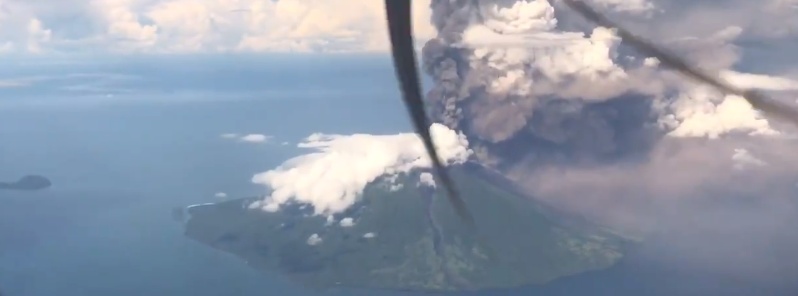
Featured image: Manam erupting on December 8, 2019. Credit: Brian Malone
Commenting rules and guidelines
We value the thoughts and opinions of our readers and welcome healthy discussions on our website. In order to maintain a respectful and positive community, we ask that all commenters follow these rules:
We reserve the right to remove any comments that violate these rules. By commenting on our website, you agree to abide by these guidelines. Thank you for helping to create a positive and welcoming environment for all.