Severe storms with large hail, strong winds, and tornadoes target Chicago, Kansas City
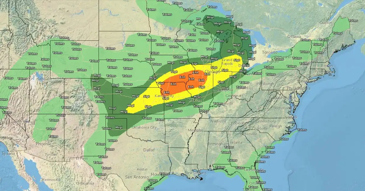
Severe thunderstorms are expected across the central Plains to the central Great Lakes on June 13, 2024. Large hail, destructive wind gusts, and tornadoes are possible, particularly in Chicago, Illinois, and Kansas City, Missouri.
A weather front extending from the Upper Great Lakes, across the Upper/Middle Mississippi Valley, and westward to the Central Rockies will move eastward to the Northeast Coast, Mid-Atlantic, and westward to the Middle Mississippi Valley and Central Plains by Saturday, June 15, producing heavy rainfall.
As a result, the Storm Prediction Center (SPC) has issued an Enhanced Risk (level 3/5) of severe thunderstorms over parts of the Middle Mississippi Valley and Western Ohio Valley through Friday morning.
The severe weather hazards associated with these thunderstorms include frequent lightning, severe thunderstorm wind gusts, hail, and a few tornadoes.
There is also an added threat of severe thunderstorm wind gusts reaching 120 km/h (75 mph) or greater from the Central Plains to the Western Ohio Valley.
Furthermore, large hail of 5 cm (2 inches) or greater is possible in the same region.
By Friday, the boundary is expected to move eastward to the Northeast, producing showers and severe thunderstorms over parts of the northern Mid-Atlantic and New England. The SPC has issued a Slight Risk (level 2/5) of severe thunderstorms for these areas from Friday through Saturday morning. The associated hazards include frequent lightning, severe thunderstorm wind gusts, and a minimal threat of tornadoes and hail.
Additionally, along the western end of the front, showers and severe thunderstorms will develop over parts of the Central High Plains and the SPC has issued a Slight Risk (level 2/5) for this region from Friday through Saturday morning, with hazards including frequent lightning, severe thunderstorm wind gusts, hail, and a few tornadoes.
There is also an added threat of severe thunderstorm wind gusts of 120 km/h (75 mph) or greater in the Central High Plains.
On Friday, showers and thunderstorms are also expected from parts of the Middle Mississippi Valley to the Central/Southern Appalachians.
The weather conditions could pose significant risks and disruptions across these regions.
References:
1 Short Range Forecast Discussion – NWS WPC – June 13, 2024
Featured image: NOAA/NWS
Commenting rules and guidelines
We value the thoughts and opinions of our readers and welcome healthy discussions on our website. In order to maintain a respectful and positive community, we ask that all commenters follow these rules.