Sarasota hit by record-breaking 1-hour rainfall, all of South Florida under Flood Watch
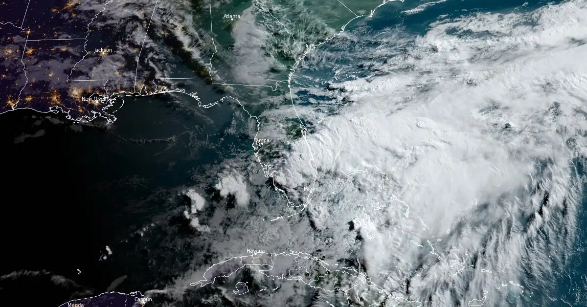
Disorganized showers and thunderstorms produced by a broad and elongated area of low pressure are affecting parts of Florida. On Tuesday, June 11, 2024, this low pressure dropped record-breaking rainfall over Sarasota, causing significant flash flooding. Heavy rain is expected to continue in the days ahead and the flood threat will remain through the end of the work-week.
- This system has moved little over the past few hours, but is expected to move northeastward across Florida and move offshore of the U.S. Southeast coast within the next day or so.
- A Flood Watch is in effect for all of South Florida through Thursday evening, June 14.
A broad area of South Florida has received between 76.2 and 177.8 mm (3 to 7 inches) of rain over the past two days. In Sarasota, over 261.6 mm (10.3 inches) was recorded in 24 hours on June 11. Of this total, 99.8 mm (3.93 inches) fell between 19:00 and 20:00 EDT, setting a new record for one-hour rainfall. Weather records in Sarasota have been maintained since 1972.
“Statistically, getting this much rain in such a short time is about a 1 : 1,000 year flood for this part of Florida,” said meteorologist Noah Bergren. “That does not mean it happens one only every thousand years, but the chance in any given year is around 0.1%!”
St Armand's Circle in Sarasota, Florida late Tuesday evening. MAJOR rains fell with significant flooding ongoing there and Bradenton.
— Noah Bergren (@NbergWX) June 12, 2024
Rain is over 10.3" just from Tuesday officially in Sarasota. In fact, 3.93" of rain fell from 7-8PM EDT Tuesday, which is the most ever observed… pic.twitter.com/tzwOkftIUz
Flooding going on in Everglades City @NWSMiami @BrandonOrrWPLG @WeatherWithLaur @AnthonyDuarte03 @JimCantore @ReedTimmerUSA #flwx #wx #wxtwitter pic.twitter.com/dEy9MeSNeJ
— Hurricane Chaser Chase (@hurricane_chase) June 11, 2024
This 48-hour loop of Total Precipitable Water (TPW) imagery tracks the deep tropical moisture inundating Florida this week. Updates at https://t.co/oQi0hWL8Q5 #FLwx pic.twitter.com/qgDtai6eXy
— UW-Madison CIMSS (@UWCIMSS) June 12, 2024
The rains are brought by a stationary front with waves extending across northern Florida and across the Gulf Coast.
This system is expected to continue producing showers and thunderstorms with heavy rain over parts of southern Florida. As a result, the Weather Prediction Center (WPC) has issued a Slight Risk (level 2/4) of excessive rainfall through Thursday morning, June 12.
The associated heavy rain will create mainly localized areas of flash flooding, with urban areas, roads, small streams, and low-lying areas the most vulnerable. Also, showers and thunderstorms will develop along parts of the Western Gulf Coast and Central/Southern High Plains.
This system has moved little over the past few hours, but is expected to move northeastward across Florida and move offshore of the U.S. Southeast coast within the next day or so, NWS forecaster Pasch noted.
“Although upper-level winds are expected to be only marginally conducive, some slow development is possible while the system moves offshore of the U.S. Southeast coast,” Pasch said.
Regardless of development, heavy rainfall is forecast to continue across portions of the Florida peninsula during the next few days.
A Flood Watch is in effect for all of South Florida through Thursday evening, June 14.
NWS is urging residents living in the affected region to monitor forecasts and be alert for possible Flood Warnings. Those living in areas prone to flooding should be prepared to take action should flooding develop.
As always, have a way to remain aware of the latest advisories and warnings from the NWS.
— NWS Miami (@NWSMiami) June 12, 2024
Here is a infographic on Flood Watches, Flood Advisories, and Flash Flood Warnings: pic.twitter.com/1orI87Mrdv
References:
1 Short Range Forecast Discussion – NWS WPC – 400 AM EDT Wed Jun 12 2024
2 Tropical Weather Outlook – NWS NHC – 200 AM EDT Wed Jun 12 2024
3 Flood Watch – NWS Miami – 144 AM EDT Wed Jun 12 2024
Featured image credit: NOAA/GOES-East, RAMMB/CIRA, The Watchers. Acquired at 11:40 UTC on June 12, 2024
Commenting rules and guidelines
We value the thoughts and opinions of our readers and welcome healthy discussions on our website. In order to maintain a respectful and positive community, we ask that all commenters follow these rules.