Destructive M7.6 earthquake in Japan results in at least 222 fatalities, 1.2 m (4 feet) tsunami waves, and a land shift of up to 3 m (10 feet)

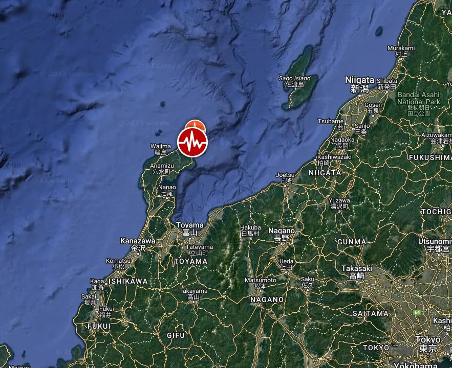
A powerful M7.6 earthquake struck Ishikawa Prefecture, Japan, at 07:10 UTC (16:10 local time) on January 1, 2024, leaving extensive damage, at least 222 fatalities, and prompting a massive rescue effort. The quake led to tsunami waves of more than 120 cm (3.9 feet) and significant crustal changes, with up to 3 m (10 feet) of displacement in some areas. The region faces ongoing aftershocks and difficult rescue conditions.
The Japan Meteorological Agency (JMA) reported the quake’s preliminary magnitude of M7.6, with the USGS and EMSC indicating a slightly lower 7.5 magnitude at a depth of 10 km (6.2 miles).
The quake was closely followed by tsunami waves that battered the western seaboard, as recorded by the Japan Meteorological Agency (JMA). The highest wave was recorded at over 120 cm (3.94 feet) at 07:21 UTC in Wajimako. The city of Toyama, Toyama prefecture, reported a tsunami of 80 cm (2.6 feet) at 07:35 UTC (16:35 LT).
| LOCATION | TIME (UTC) | MAXIMUM WAVE HEIGHT (cm/feet) |
|---|---|---|
| WAJIMAKO | 07:21 | Over 120 cm (3.94 feet) |
| TOBISHIMA | 08:52 | 40 cm (1.31 feet) |
| SAKATA | 08:22 | 30 cm (0.98 feet) |
| NIIGATA | 08:09 | 30 cm (0.98 feet) |
| KASHIWAZAKISHI KUJIRANAMI | 07:36 | 40 cm (1.31 feet) |
| KANAZAWA | 08:46 | 50 cm (1.64 feet) |
| TOYOOKASHI TSUIYAMA | 08:52 | 30 cm (0.98 feet) |
| OKUSHIRITO OKUSHIRIKO | 08:28 | 10 cm (0.33 feet) |
| AKITA | 08:36 | 10 cm (0.33 feet) |
| MAIZURU | 08:49 | 10 cm (0.33 feet) |
| IWAMICHO TAJIRI | 08:46 | 10 cm (0.33 feet) |
| SAIGO | 08:50 | 30 cm (0.98 feet) |
Rail services and flights have been suspended, with over 500 people stranded at Noto’s airport due to infrastructural damage.
In Suzu, close to the epicenter, approximately 1 000 houses may be destroyed, a situation described by the mayor as catastrophic.
The fire department in Wajima City reported that about 200 buildings were believed to have burned down on Asaichi Street, a popular tourist area in Wajima, in a fire that broke out during the quake. The department also said 25 buildings, including houses, had collapsed, and 14 structures may still have people trapped inside, according to NHK.
Hokuriku Electric’s Shika plant, closest to the epicenter, reported power outages and oil leaks but no radiation leakage.
Additionally, local industries like Toshiba’s semiconductor production and Kokusai Electric’s chip equipment manufacturing are halting operations to assess and repair damage.
Rescue teams, consisting of 3 000 army personnel, firefighters, and police officers, are reporting issues reaching isolated areas on the Noto Peninsula, where roads are wrecked, buildings toppled, and power has been cut to tens of thousands of homes.
In Ishikawa Prefecture, about 33 000 households are without power, and nearly 20 000 homes lack water supply following a night of sub-freezing temperatures, as reported by Hokuriku Electric Power’s website.
The earthquake has also caused significant crustal changes in the Noto region near the epicenter, with up to 3 m (10 feet) of shift observed in parts of Wajima City and around 1 m (3 feet) in Suzu City. These findings were reported by the Geospatial Information Authority (GSI) using data from Japan’s DAICHI-2 earth observation satellite.
Comparatively, this shift is significant when considering the 1 to 2 m (3 – 6 feet) of crustal change observed during the 2016 Kumamoto quakes and 1.5 m (5 feet) from the 2008 M7.2 quake in Iwate and Miyagi Prefectures.
The quake has heightened concerns about the country’s nuclear industry, still recovering from the 2011 Fukushima disaster. Despite no reported irregularities at nuclear plants along the Sea of Japan, the event coincides with the lifting of an operational ban on the Kashiwazaki-Kariwa nuclear plant.
Seismic experts in Japan have been observing increased seismic activity under the Noto Peninsula for years, attributing this uptick to the subterranean movement of fluids.
Professor Takuya Nishimura of Kyoto University suggests that these fluids, flowing about 15 km (9 miles) underground, may have instigated the New Year’s Day earthquake by making surrounding faults more slippery and active. He emphasizes that the recent quake’s impact was more extensive than previously observed seismic activities in the region, indicating a larger affected area.
Nishimura warns of the potential for increased seismic activity not just around the quake’s epicenter but also in the broader surrounding areas. He notes that earlier seismic activity was confined to a 30 km (18 miles) width, but the recent 7.6 magnitude earthquake occurred over a much wider expanse, possibly due to the release of energy from underground fluids affecting a larger area.
Meanwhile, Professor Toda Shinji of Tohoku University highlights that the active fault itself might have shifted over a stretch of more than 100 km (62 miles), significantly expanding the area of concern for future seismic events. Based on his investigations, the fault began shifting around Suzu City and expanded towards Sado City and Wajima City, implying a total fault length of over 100 km (62 miles). The energy released by this earthquake was notably five times that of the main quake that hit Kumamoto in 2016 (M7.0).
Both experts stress the need for heightened caution, considering the likelihood of future earthquakes and the potential for tsunamis, especially with such a significant fault line shift and the quake’s undersea location.
Japan is a seismically active region, with most earthquakes occurring off the east coast, where the Pacific plate subducts beneath Japan, the USGS noted.
This earthquake occurred on the west coast of Japan where crustal deformation created by the broader plate motions is accommodated in shallow faults. Shallow earthquakes cause more damage than intermediate- and deep-focus ones since the energy generated by the shallow events is released closer to the surface and therefore produces stronger shaking relative to earthquakes located deeper within the Earth. This coastal earthquake produced both strong shaking on land and generated a tsunami.
While earthquakes are common in Japan, the region surrounding the January 1, 2024, earthquake sees lower rates of seismicity as compared to the major subduction zone along its east coast. Still, since 1900, 30 other M6 and larger earthquakes have occurred within 250 km (155 miles) of the January 1 event.
Three of these occurred on or near the Noto Peninsula, where the January 1 event is located. On May 5, 2023, a M6.2 earthquake on the Noto Peninsula killed one person and damaged hundreds of buildings.
On June 16, 1964, a M7.6 occurred 205 km (127 miles) east-northeast of the January 1 event, resulting in 36 fatalities and roughly 3 500 destroyed homes.
Updates
January 8 at 09:03 UTC
The death toll has climbed to 161 with 103 people still missing, aged between 8 and 95, as of January 8. Around 10 000 individuals in Ishikawa Prefecture are taking shelter in evacuation centers, and over 2 000 remain isolated due to damaged roads. Rescue efforts are being complicated by heavy snowfall and sub-zero temperatures, leading the government to plan on-foot food deliveries. A water shortage a week after the tragedy is worsening hygiene and sanitary conditions in the area.
The cities of Wajima and Suzu accounted for the majority of the confirmed total.
Additionally, 5 people were killed at Tokyo Haneda airport on Tuesday, January 2 when a Japan Airlines jet collided with a coast guard plane on its way to provide earthquake relief.
09:57 UTC, January 9
The death toll has risen to 202 and there are still more than 100 people unaccounted for, according to Ishikawa Prefecture officials.
Police in Wajima have launched an intensive search for missing persons.
A major fire in Wajima’s city center destroyed over 200 buildings, covering an area of 48 000 m2 (516 000 ft2).
In the Noto region of Ishikawa Prefecture, more than 3 000 people remain isolated, NHK reports.
Evacuee and volunteer Yamashita Kanako at a Wajima City shelter reports a shortage of drinking water, with residents boiling spring water and fetching river water to flush toilets. Road damage has prompted relief organizers to employ drones for delivering medicine to those cut off in Wajima City’s Konosu district, with plans to continue drone support for those in need.
The earthquake’s impact on Ishikawa’s fishing industry is severe. More than 120 fishing boats were capsized or sunk, and over 70% of the ports sustained damage, indicating a lasting effect on the region’s vital industry.
11:21 UTC, January 15
As of 05:00 UTC, the death toll in Ishikawa Prefecture has risen to 222, as reported by the prefectural government.
This figure includes 14 disaster-related deaths caused by health deterioration during evacuation. The fatalities are distributed across various municipalities: 99 in Suzu, 88 in Wajima, 20 in Anamizu, 7 in Noto, 5 in Nanao, 2 in Shika, and 1 in Hakui. Additionally, 22 people remain unaccounted for, with 18 in Wajima and 4 in Suzu.
References:
1 Massive M7.6 earthquake hits near the west coast of Honshu, Japan — major tsunami warning issued for Ishikawa – The Watchers – January 1, 2024
2 Earthquake causes land shift of up to 3 meters – NHK – January 2, 2024
3 Casualties rising after Monday’s massive quake on Sea of Japan coast – NHK – January 2, 2024
4 Rescue teams search for quake survivors in Ishikawa as death toll reaches 48 – Japan Today/Reuters – January 2, 2024
5 Japan earthquake: At least 48 people dead – NHK – January 2, 2023
Featured image credit: NHK (stillshot)
Decent written report but would have preferred seeing video directly from original sources themselves rather than from msm who are no longer respected worldwide.