
New insights into the enigmatic 1693 AD tsunami in the eastern Mediterranean Sea

Image credit: Nature, authors
A new study published in Nature provides new insights into the triggering mechanisms and propagation dynamics of the enigmatic 1693 tsunami in the eastern Mediterranean Sea.
The disastrous earthquake of 1693 AD caused over 60 000 causalities and the total destruction of several villages and towns in south-eastern Sicily, Italy. Immediately after the earthquake, a tsunami struck the Ionian coasts of Sicily and the Messina Strait and was probably recorded even in the Aeolian Islands and Malta.
Over the last few decades, the event has been much debated regarding the location of the seismogenic source and the possible cause of the associated tsunami. The marine event has been related to both a submarine landslide and a coseismic displacement at the seafloor.
To better define the most reliable sources and dynamics of the tsunami, a team of researchers coupled high-resolution marine seismic survey data with hydrodynamic modeling to simulate various scenarios of tsunami generation and propagation. Results from the simulations were compared with geomorphological evidence of past tsunami impacts, described in previous work along the coast of south-eastern Sicily, and within historical chronicles and reports.
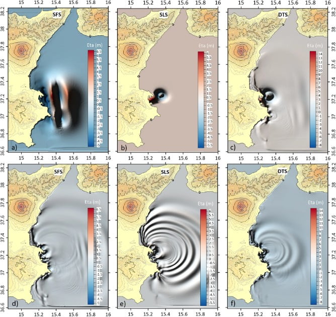
The most reliable scenario considers the 1693 event was composed by two different tsunami waves: a first wave generated by the coseismic fault displacement at the seafloor and a second wave generated by a submarine landslide, triggered by the earthquake shaking.
Tsunami modeling shows that a simultaneous movement between fault displacement and submarine mass movement could determine a destructive interference on the tsunami waves, resulting in a reduction in wave height.
For this reason, the second tsunami wave probably occurred with a maximum delay of a few minutes after the one generated by the earthquake and induced greater flooding.
The double-source model could explain the observation because in the course of other destructive earthquakes in south-eastern Sicily, such as that of 1169 AD, the associated tsunami caused less damage.
References:
The enigmatic 1693 AD tsunami in the eastern Mediterranean Sea: new insights on the triggering mechanisms and propagation dynamics – Scicchitano, G., Gambino, S., Scardino, G. et al. – Sci Rep 12, 9573 (2022). https://doi.org/10.1038/s41598-022-13538-x – OPEN ACCESS
I'm a dedicated researcher, journalist, and editor at The Watchers. With over 20 years of experience in the media industry, I specialize in hard science news, focusing on extreme weather, seismic and volcanic activity, space weather, and astronomy, including near-Earth objects and planetary defense strategies. You can reach me at teo /at/ watchers.news.
Commenting rules and guidelines
We value the thoughts and opinions of our readers and welcome healthy discussions on our website. In order to maintain a respectful and positive community, we ask that all commenters follow these rules.