Severe cold snap hits Europe after unseasonable warmth, high-risk for catastrophic morning frost
Central Europe is facing a high risk of catastrophic morning frost over the next few days, as cold air threatens extensive damage to agriculture across the region. Meteorologists from Severe Weather Europe have issued warnings about potentially severe impacts on blooming fruit trees, vineyards, and crops following a swift transition from unusually warm conditions.
Over the past two weeks, much of Europe experienced record-high temperatures for April, promoting early blooming in many plants. However, this was followed by an abrupt weather reversal, introducing a critical phase for agricultural areas, particularly as night temperatures plummeted.
Slovenia has become a notable example of this sharp climatic shift. On April 16, following more than ten days of summer-like weather with highs exceeding 30 °C (86 °F), the country reported a drastic change. Temperatures fell to icy levels accompanied by wind, rain, and snow, causing not only agricultural concerns but also traffic disruptions and minor damage from weather conditions.
The most significant temperature drop was recorded in Podčetrtek, a town in eastern Slovenia, where temperatures fell from 27.2°C (81.0 °F) on the afternoon of April 15 to just 1 °C (33.8 °F) by 15:00 LT the following day, marking a record decline of 26.2 °C (47.2 °F).
This severe temperature fluctuation poses a direct threat to the region’s agriculture, particularly to the fruit trees and vineyards now vulnerable after early blooming.
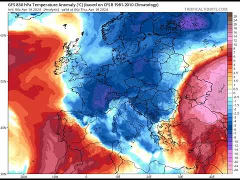
The next few days will sadly result in what we were afraid of. There is a high-risk potential for a catastrophic morning frost across most of central Europe. The air mass is so cold for late April that it could significantly damage blooming fruit trees, vineyards, and crops. pic.twitter.com/6WU4gtv6lJ
— severe-weather.EU (@severeweatherEU) April 20, 2024
From summer-style warmth to a late winter chill…
— Scott Duncan (@ScottDuncanWX) April 20, 2024
Much of Europe experiences the full range April has to offer in just a few days. The amplified jet stream is a crucial feature for delivering the cold to Europe. pic.twitter.com/PdRrHcBj0A
The cold snap’s timing is particularly detrimental as the sudden frost can destroy new growth on plants, which had advanced due to the preceding warm period. The potential losses for local farmers, who rely on these crops for their livelihood, could be significant if the frost persists or intensifies.
The full extent of the impact will depend on the duration of the cold spell and the effectiveness of response strategies employed by affected agricultural communities.
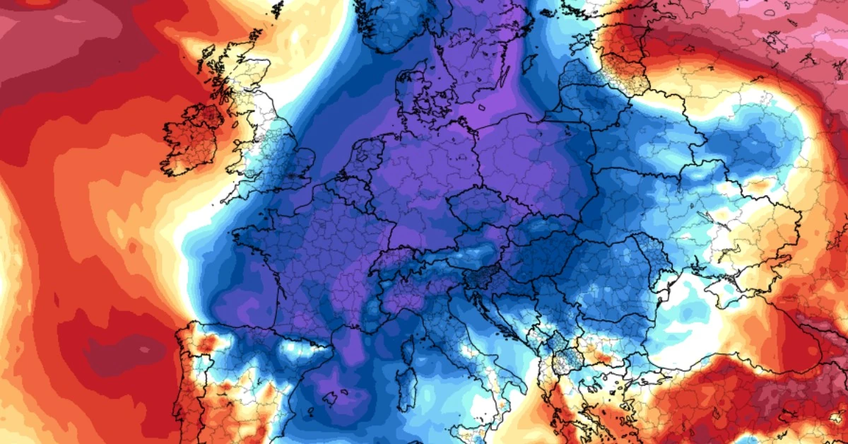
Weather models today suggest very cold temperatures are expected to persist across most of central Europe through April 25. They will warm up a bit after April 25, but generally cold temperatures will then include the entire Europe, from north to south and east to west through the end of the month and into May.
Featured image credit: Tropical Tidbits/GFS. Model run 00:00 UTC on April 21 for 12:00 UTC on April 22, 2024
Commenting rules and guidelines
We value the thoughts and opinions of our readers and welcome healthy discussions on our website. In order to maintain a respectful and positive community, we ask that all commenters follow these rules.