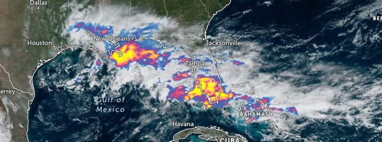
• Major snowstorm expected to hit Ontario, Canada

    A Texas low is bringing the potential for significant snowfall to southern Ontario, with the City of Toronto expecting accumulations of up to 15 cm (5.9 inches) on Wednesday and Thursday, January 25 – 26, 2023. This powerful storm system is expected to bring difficult travel conditions and reduced visibility, making it important for residents to plan ahead and consider postponing non-essential travel.

  • Storm Gerard hits France with hurricane-force winds

    A powerful low pressure system, named Storm Gerard by Météo France, brought heavy rainfall, strong winds, and thunderstorms to northern and western France on Sunday, January 15, and Monday, January 16, 2023, resulting in significant weather-related incidents and causing casualties and damage. This is the 22nd named storm of the 2022/23 European windstorm season, including two ex-hurricanes (Danielle and Martin).

  • Significant flooding risks in Queensland’s Central Coast, Australia

    Heavy rainfall and flooding continue to impact Queensland’s Central Coast. A Severe Weather Warning is current for heavy to locally intense rainfall between Ayr and St Lawrence, and adjacent inland areas, including Mackay, Proserpine and Bowen. Many catchments in northern and central Queensland are experiencing minor to major flooding, and dangerous flash flooding remains possible.

  • Winter storm to bring heavy snow to High Plains and Great Lakes, impactful freezing rain possible

    A winter storm is forecasted to form on Tuesday evening, January 17, 2023, in the eastern regions of Colorado before traversing northeastward through Thursday, January 19. This system is anticipated to bring copious amounts of snowfall to the High Plains region and western Great Lakes area, with the possibility of substantial freezing rain. Expect significant disruptions to travel in affected areas.

  • Endless onslaught of atmospheric river events in California claim 14 lives, residents urged to be hyper-vigilant

    California is once again under threat as an energetic low pressure system quickly gathers strength off the West Coast, bringing with it heavy precipitation, thunderstorms and several feet of snow in the Sierra Nevada region. This, along with already saturated soils and high river levels, is expected to exacerbate ongoing flooding, prolong the risk of flash flooding, and mudslides, especially in recent burn scar regions. The National Weather Service has issued a warning for residents to be prepared, as the heavy rainfall, especially in southern California, is expected to be excessive today and tonight.

  • Parade of intense storms continues to batter California — rapid river rises, mudslides, and burn scar flash floods expected

    The continuous rounds of heavy rain on already saturated soils across California will likely lead to significant flooding, rapid river rises, mudslides, and flash floods or debris flows in burn scar areas. In addition, gusty winds may cause trees and power lines to fall. Travel in the mountains may also be hazardous due to heavy snowfall.

  • Multi-hazard storm moves into the Plains, U.S.

    A multi-hazard storm will bring a swath of heavy snow, sleet, and ice in the north and central Plains and Upper Midwest during the next couple of days, the National Weather Service (NWS) warns. Across the Arklatex region and into the Mid-South, severe storms with all hazards and heavy to excessive rain can be expected, with the primary severe threats of tornadoes, some strong, and damaging winds.