Record-breaking tornado damage length for May 26 storms

The National Weather Service (NWS) office in Paducah, Kentucky announced on June 5 that storms on May 26, 2024, produced 16 tornadoes in their forecast area, resulting in a record-breaking 410 km (255 miles) of tornado damage.
- During the month of May, there were two historic severe weather events in the NWS Paducah forecast area — on May 8 and 26.
- The May 8 event shattered the previous single-day record for most warning issuances by the Paducah office.
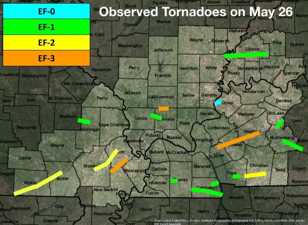
- A total of 16 tornadoes were observed in the NWS Paducah forecast area on May 26, resulting in a record-breaking 410 km (250 miles) of tornado damage.
- The May 26 severe weather event also had the second-highest single-day warning issuance count in office history.
The NWS office in Paducah is responsible for monitoring weather conditions across 58 counties in parts of Kentucky, Illinois, Indiana, and Missouri. This extensive coverage includes major cities like Evansville, Hopkinsville, Owensboro, Carbondale, Cape Girardeau, and Paducah.
There were two historic severe weather events that impacted the region under their watch in May 2024.
The first occurred on May 8 when several rounds of storms occurred throughout a nearly 24-hour period beginning late evening on May 7. The most widespread damage occurred during the afternoon and evening of May 8 as multiple bowing segments and several supercells occurred.
9 tornadoes touched down while training storms resulted in flash flooding with rainfall totals of 50 to 100 mm (2 – 4 inches) in many areas, locally up to 127 – 152 mm (5 – 6 inches).
This event resulted in the single-day record for most warning issuances (Severe Thunderstorm Warning, Tornado Warning, and Flash Flood Warning) by the Paducah office of 117, shattering the old record of 71.
The second severe weather event occurred on May 26 when multiple rounds of severe thunderstorms occurred. The first was a bowing line crossing Southeast Missouri into Western Kentucky and far Southern Illinois from 05:00 to 10:00 LT, producing a wide swath of wind damage and several tornadoes.
Supercells formed near sunset producing several more tornadoes while a line of storms moved across the Quad State from 07:00 to 11:00 LT, bringing a second round of widespread wind.
At least 100 000 customers were without power across the Quad State region at the peak of this event. Flash flooding occurred with the morning and evening rounds of storms.
In their May 2024 Climate Summary, the office reported a preliminary number of 14 tornadoes, including 3 EF-3s. The May 26 event also had the second-highest single-day warning issuance count in office history, only behind the May 8 record.
However, on June 5, the office announced the number of tornadoes produced on May 26 rose to 16 — resulting in an ‘astounding’ 410 km (255 miles) of tornado damage.
This now marks a record-shattering length of tornado damage in their forecast area.
The previous record was 260 km (162 miles) of damage set on February 29, 2012.
The storms on May 26th produced a record-shattering 255 miles of tornado damage across our 58 county area. This surpassed Feb 29, 2012 and Dec 10, 2021 for the number of miles that tornadoes tracked across parts of our region. pic.twitter.com/ANJVcEJmyq
— NWS Paducah, KY (@NWSPaducah) June 5, 2024
The table below contains all events with 160+ km (100+ miles) of tornado damage, without mileage for parts of tornadoes that began or ended outside of any of the counties under their watch.
| Rank | Date | Length |
| 1 | May 26, 2024 | 410 km (255 miles) |
| 2 | February 29, 2012 | 260 km (162 miles) |
| 3 | December 10, 2021 | 255 km (159 miles) |
| 4 | May 25, 2011 | 243 km (151 miles) |
| 5 | December 18, 1957 | 215 km (135 miles) |
| 6 | May 6, 2003 | 189 km (118 miles) |
| 8 | February 28, 2017 | 189 km (118 miles) |
| 8 | April 2, 2024 | 185 km (115 miles) |
| 9 | November 17, 2023 | 185 km (115 miles) |
References:
1 May 2024 Climate Summary – NOAA/NWS Paducah – June 2024
Featured image credit: Observed tornadoes in the NWS Paducah forecast area on May 26, 2024. Credit: NOAA/NWS
Commenting rules and guidelines
We value the thoughts and opinions of our readers and welcome healthy discussions on our website. In order to maintain a respectful and positive community, we ask that all commenters follow these rules.