Earthquake swarm under Bardarbunga volcano, Iceland
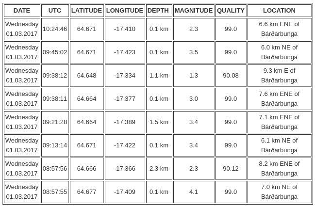
An earthquake swarm started under Bardarbunga volcano, Iceland during the early morning hours of Wednesday, March 1, 2017. The swarm started at 08:57 with M4.1 (the strongest) and ended at 10:24 UTC. There were no additional earthquakes registered over the next 24 hours.
Bryndís Ýr Gísladóttir, a specialist in natural hazards with the Icelandic Met Office told media that five powerful earthquakes were detected in the caldera of Bardarbunga volcano on March 1, 2017.
The sequence started with M4.1 at 08:57 UTC at a very shallow depth of 0.1 km (0.06 miles) and continued with M2.3 at a depth of 2.3 km (1.5 miles) within the first minute. In total, there were 5 earthquakes with magnitude above 3.0.
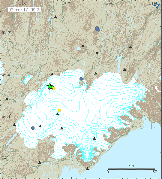
Credit: IMO
Data source: IMO. Updated at 10:00 UTC, March 2, 2017
Bryndís insists that there are currently no signs of magma unrest in the area and that earthquakes have been common since the volcanic eruption in Bárðabunga ended in 2015. A similar incident happened in January 2017.
Geological summary
The large central volcano of Bárðarbunga lies beneath the NW part of the Vatnajökull icecap, NW of Grímsvötn volcano, and contains a subglacial 700-m-deep caldera. Related fissure systems include the Veidivötn and Trollagigar fissures, which extend about 100 km SW to near Torfajökull volcano and 50 km NE to near Askja volcano, respectively.
Voluminous fissure eruptions, including one at Thjorsarhraun, which produced the largest known Holocene lava flow on Earth with a volume of more than 21 cu km, have occurred throughout the Holocene into historical time from the Veidivötn fissure system.
The last major eruption of Veidivötn, in 1477, also produced a large tephra deposit. The subglacial Loki-Fögrufjöll volcanic system to the SW is also part of the Bárðarbunga volcanic system and contains two subglacial ridges extending from the largely subglacial Hamarinn central volcano; the Loki ridge trends to the NE and the Fögrufjöll ridge to the SW. Jökulhlaups (glacier-outburst floods) from eruptions at Bárðarbunga potentially affect drainages in all directions. (GVP)
Featured image credit: EMSC
Commenting rules and guidelines
We value the thoughts and opinions of our readers and welcome healthy discussions on our website. In order to maintain a respectful and positive community, we ask that all commenters follow these rules:
We reserve the right to remove any comments that violate these rules. By commenting on our website, you agree to abide by these guidelines. Thank you for helping to create a positive and welcoming environment for all.