The fullest investigation of the massive Hunga Tonga-Hunga Ha’apai eruption to date
In January 2022, Hunga Tonga-Hunga Ha’apai (HT-HH) emitted the biggest atmospheric explosion recorded on Earth in more than 100 years. Several months after the eruption1, a New Zealand-led team has completed the fullest investigation to date into the eruption of this underwater Tongan volcano.
- Funded by The Nippon Foundation, NIWA and SEA-KIT surveyed over 22 000 km2 (8 500 mi2) surrounding the volcano, including mapping 14 000 km2 (5 405 mi2) of previously unmapped seafloor
- They discovered that almost 10 km3 (2.4 mi3) of the seafloor was displaced – with two-thirds coming from the summit and the rest from the surrounding flanks
- Pyroclastic flows produced by the eruption extended perhaps as far as 100 km (62 miles) away, marking the first time that scientists have observed underwater pyroclastic flows of this magnitude
- The survey also found evidence that the volcano is still erupting
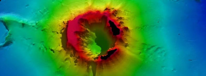
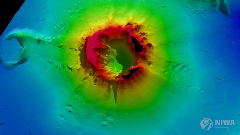
New Zealand’s National Institute for Water and Atmospheric Research (NIWA) has discovered that almost 10 km3 (2.4 mi3) of the seafloor was displaced during the eruption of Hunga Tonga-Hunga Ha’apai volcano on January 15, 2022 — with two-thirds coming from the summit and the rest from the surrounding flanks.
Three-quarters of this material was deposited within 20 km (12.4 miles) of the volcano, which left almost 3.2 km3 (0.76 mi3) unaccounted for.
The project leader, NIWA marine geologist Kevin Mackay, said this missing debris could be partly explained by aerial loss.2
“This is why we didn’t notice the loss until we had mapped everything,” said Mackay.
“The eruption reached record heights, being the first we’ve ever seen to break through into the mesosphere,” Mackay said.
“It was like a shotgun blast directly into the sky. The volume of this ‘shotgun’ plume is estimated to be 1.9 km3 (0.45 mi3) of material, which has been circulating in our atmosphere for months, causing the stunning sunsets [volcanic twilights] we saw following the eruption.”
Another research, led by Simon Proud and published this month in Science, used geostationary satellite images of the eruption to show that its volcanic cloud reached an altitude of 57 km (35.4 miles / 187 000 feet) above sea level at its highest extent.1
This makes it the highest volcanic cloud ever recorded. It is also the first time a volcanic plume has been seen to penetrate the stratopause.
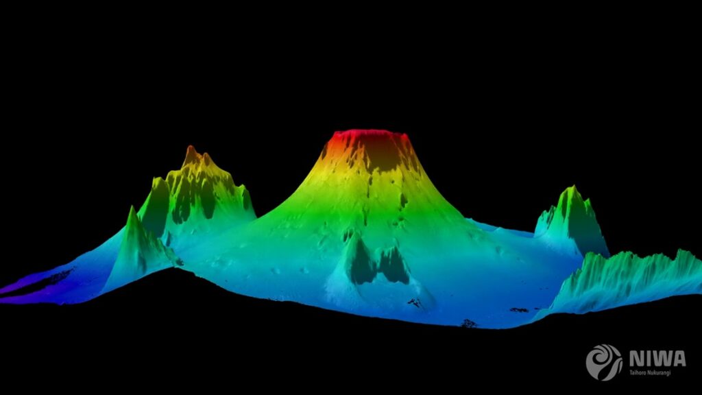
Despite the huge displacement of material, the volcano’s flank remains surprisingly intact. However, the caldera, or crater, is now 700 m (2 295 feet) deeper than before the eruption.
Further evidence from the caldera shows signs that the volcano is still erupting. A robot boat remotely operated from the UK by SEA-KIT International detected active venting from newly formed cones, explaining why glass fragments formed from cooled molten lava were picked up during NIWA’s earlier survey.
NIWA scientists have also unraveled one of the biggest unknowns of the eruption – the pyroclastic flows. Pyroclastic flows are currents made up of dense lava, volcanic ash, and gases that can reach temperatures of 1 000 °C (1 832 °F)and speeds of 700 km/h (435 mph).
Samples collected by NIWA showed pyroclastic deposits some 80 km (50 miles) away from the volcano. But Dr. Emily Lane, NIWA Principal Scientist – Natural Hazards, believes they could have traveled even further.
“Eighty kilometers was the end of our survey range, but the pyroclastic flows appear to extend beyond that distance, perhaps as far as 100 km [62 miles] away. They are also what caused both the domestic and international communications cables to break, with the domestic cable now being buried under 30 m (100 feet) of eruptive material.
“The sheer force of the flows is astonishing – we saw deposits in valleys beyond the volcano, which is where the international cable lies, meaning they had enough power to flow uphill over huge ridges and then back down again.”
Dr. Emily Lane, NIWA Principal Scientist – Natural Hazards
On land, the heat from pyroclastic flows creates a frictionless boundary layer that allows them to move so rapidly. However, Mackay says this is the first time that scientists have observed underwater pyroclastic flows of this magnitude.
“It’s the interaction with water that made this event so unprecedented. It’s still speculation but the latest science shows that this phenomenon may be more exaggerated underwater. This could be why the pyroclastic flow traveled so far and with such force,” he said.
When heated, water can expand to around 1 000 times its volume. When you get several cubic kilometers of hot magma instantly hitting the cold saltwater, this reaction is supercharged, and all that energy must go somewhere – and the only options are to explode up or sideways out of the volcano.

“While this eruption was large – one of the biggest since Krakatoa in 1883 – there have been others of similar magnitude since then that didn’t behave in the same way. The difference here is that it’s an underwater volcano and it’s also part of the reason we got such big tsunami waves,” said Mackay.
Dr. Lane said that because these volcanos are not just found in the Pacific, but the world over, we must know what happened and why it was so violent.
“The pressure anomaly generated by this eruption supercharged the tsunami so that it was able to travel right across the Pacific and worldwide. This mechanism meant that it could travel further and faster than our warning systems expected. The Krakatoa eruption was the last time a volcanic tsunami on this scale occurred,” she said.
The significant reshaping of the seafloor also had dramatic effects on ecosystems in the region.
There was little sign of any animal life on the flanks of the volcano, in deeper water channels, and in most of the surrounding seafloor.
However, there were patches of abundant life that had survived the eruption on several seamounts, giving hope for recovery.
References:
1 Hunga Tonga–Hunga Haʻapai eruption created the highest volcanic cloud ever recorded – The Watchers – November 6, 2022
2 Tonga eruption confirmed as largest ever recorded – NIWA – November 21, 2022
Featured image credit: NIWA-Nippon Foundation TESMaP
Commenting rules and guidelines
We value the thoughts and opinions of our readers and welcome healthy discussions on our website. In order to maintain a respectful and positive community, we ask that all commenters follow these rules:
We reserve the right to remove any comments that violate these rules. By commenting on our website, you agree to abide by these guidelines. Thank you for helping to create a positive and welcoming environment for all.