Significant increase in seismicity under Chiles-Cerro Negro volcanic complex
A new increase in seismic activity has been recorded under Chiles-Cerro Negro volcanic complex and its surroundings since May 2022, which includes volcano-tectonic and long-period earthquakes (now at more shallow depths than those recorded in previous years).
- This volcanic complex is located on the border of Ecuador and Colombia, 24 km (14.9 miles) W of the city of Tulcan and 130 km (80 miles) N of Quito.
- There are no confirmed historical records of eruptive activity for the Chiles and Cerro Negro volcanoes.
- There were several episodes of increased seismicity under this volcanic complex in recent years.
- The higher, glacier-covered summit of Chiles, about 4 km (2.5 miles) ESE of Cerro Negro, last erupted about 160 000 years ago.
The current seismic activity reached a peak on the morning of July 25 with a Mw5.6 earthquake and series of aftershocks.
The seismicity has been accompanied by a vertical deformation of the ground and changes in the composition of the surface fluids associated with the hydrothermal system – suggesting a magmatic source probably closer to the surface.
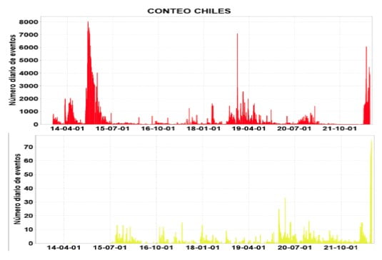
A series of seismic events began in the area surrounding the Chiles-Cerro Negro Volcanic Complex (CVCCN) in 2013, triggering a seismic crisis felt by residents of the towns of Chiles in Colombia and Tufiño in Ecuador.
Seismicity peaked on October 20, 2014, with the occurrence of a Mw5.6 earthquake and more than 8 000 volcano-tectonic (VT) earthquakes per day. This earthquake, despite being relatively large, did not cause significant damage, but it was felt in very distant areas, such as Quito, the capital of Ecuador located more than 120 km (74 miles) away, and in the city of Pasto, capital of the department of Nariño, Colombia, located 90 km (56 miles) away.
Since then, several earthquake swarms have been recorded in the area, including felt events with magnitudes close to 5.
The complex interaction between the CVCCN magmatic system, the regional tectonic faults and the hydrothermal system play a crucial role for the interpretations of the processes that occur in this zone.
A new increase in seismic activity started on May 27, 2022, with more than 1 000 earthquakes per day. Most of them are volcano-tectonic quakes, typically related to rock fracturing.
However, in the last week, the seismic monitoring networks of Ecuador and Colombia have additionally detected the presence of long period (LP) and very long period (VLP) events, which are typically related to movements of magmatic or hydrothermal fluids in volcanic systems.
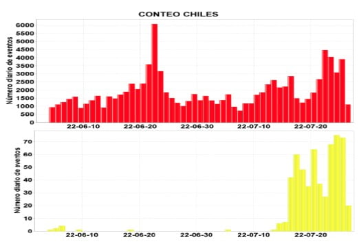
An example of these LP earthquakes occurred on July 16 at 10:38 local time, which reached a magnitude of 3.3 and was reported as felt in the surrounding towns.
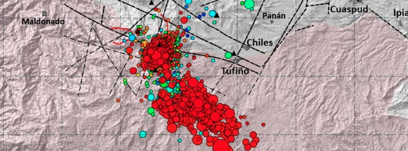
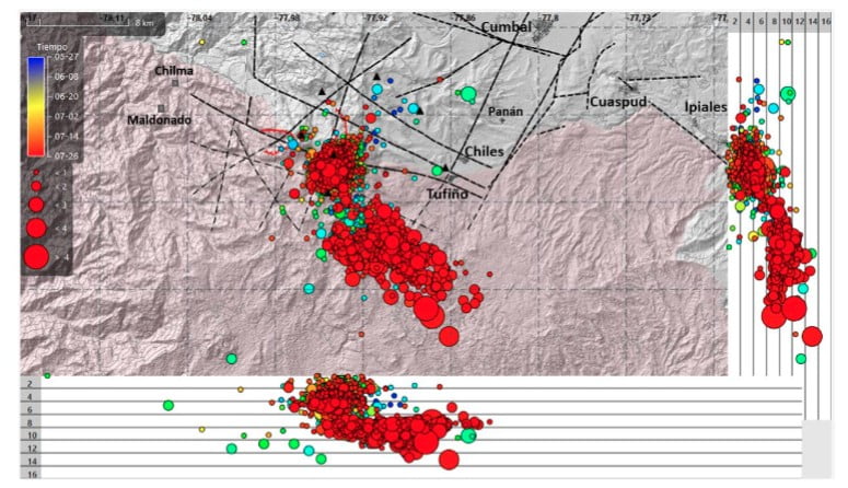
From May 27 to July 26, around 17 738 earthquakes were located. Until the afternoon of July 23, the seismic sources were concentrated below the top of the Chiles volcano and about 3.5 km (2.1 miles) south of it, with depths from 4 km (2.4 miles) above sea level to 2 km (1.2 miles) below it; while LP and VLP events were concentrated at depths between 1 and 2 km (0.6 – 1.2 miles) above sea level.
At 08:33 LT on July 25, a Mw5.6 earthquake was recorded, with an epicenter about 10 km (6.2 miles) south of Tufiño (Carchi province, Ecuador), followed by a series of aftershocks of smaller magnitudes.
Damage to buildings has been reported in San Gabriel, Tulcán and El Ángel (Ecuador) and in the Municipalities of Túquerres and Cumbal (Colombia).
According to the indicators derived from volcanic monitoring, there is evidence of an evolution in activity in the CVCCN region characterized by:
1. An increase in deformation from April 2022 with an inflationary pattern on the southern flank of Chiles and Caldera de Potrerillos.
2. Increase in the occurrence of earthquakes associated with rock fracturing (VT) since the end of May 2022, highlighting the presence of seismic sources closer to the Chiles volcano, with more superficial hypocenters. This is coupled with a greater attenuation of the coda waves, which suggests a medium with a greater supply of fluids, and which is also reflected in the occurrence of earthquakes associated with fluid dynamics (LP).
3. Physical-chemical changes in hot springs: gaseous emissions, high temperatures and morphological changes (El Hondón) indicating a disturbance of the hydrothermal system caused by seismicity and interaction with the magmatic system.
Possible scenarios
It is important to indicate that the scenarios, as well as their order of probability of occurrence, may be modified depending on the changes observed in the geophysical and geochemical parameters.
Based on their probability of occurrence, three possible scenarios are currently considered:
1. Fluctuations in activity as it has been occurring since 2013. In this case, it is possible that increases in seismicity will be triggered by events of greater magnitude, such as what occurred on the morning of July 25. Due to the fluctuating nature of the activity, it is possible to subsequently return to lower levels of seismic activity, that is, a decrease in the number of events and magnitudes.
2. Increased volcano-tectonic activity: greater number of LP-type earthquakes or occurrence of volcanic tremors with shallower locations, greater deformation and increase in gaseous species associated with the magmatic system. This would indicate processes related to the hydrothermal system, with manifestations on the surface such as: temperature increases in thermal springs, formation of cracks and possible phreatic explosions. It is possible that earthquakes of greater magnitude will occur.
3. Evolution of the monitoring parameters that show a more superficial activity which could progress towards an eruptive process, which may initially be of the phreatic type, eventually evolving to phreato-magmatic activity and ultimately to a magmatic activity.
Note: The occurrence of earthquakes of greater magnitude can generate instability on slopes, landslides, as well as structural damage to buildings.
The nearby population is recommended to stay informed only through official channels and to be aware of the evolution of the activity of the CVCCN.
Stay away from hot springs as changes in emission rates or gas composition can be harmful to health. In addition, because they are unstable areas with high temperatures, they could represent a risk to life.
Geological summary
The Chiles-Cerro Negro volcanic complex includes both the Pleistocene Chiles and the Cerro Negro de Mayasquer stratovolcanoes astride the Colombia-Ecuador border.
Cerro Negro has a caldera open to the west, with andesitic and dacitic lava flows of possible Holocene age (Hall 1992, pers. comm.) and solfataras on the shore of a small crater lake.
An eruption reported in 1936 (VEI 2) may have been from Reventador.
The higher, glacier-covered summit of Chiles, about 4 km (2.5 miles) ESE of Cerro Negro, last erupted about 160 000 years ago, but it has a caldera open to the north with hot springs and an active hydrothermal system on its eastern flank.2
References:
1 INFORME ESPECIAL COMPLEJO VOLCÁNICO CHILES –CERRO NEGRO No.2022-003 – Informe Técnico Conjunto: Incremento de la actividad sísmica y volcánica – July 26, 2022
2 Chiles-Cerro Negro – Geological summary – GVP
Featured image credit: IGEPN
Commenting rules and guidelines
We value the thoughts and opinions of our readers and welcome healthy discussions on our website. In order to maintain a respectful and positive community, we ask that all commenters follow these rules:
We reserve the right to remove any comments that violate these rules. By commenting on our website, you agree to abide by these guidelines. Thank you for helping to create a positive and welcoming environment for all.