Massive eruption at Hunga Tonga-Hunga Ha’apai produces huge shockwave and tsunami, Tonga
A massive eruption took place at Hunga Tonga-Hunga Ha’apai volcano in Tonga at 04:10 UTC on January 15, 2022, producing a huge shockwave and a 1.2 m (4 feet) high tsunami.
The eruptive cloud is reaching an altitude of at least 15.2 km (50 000 feet) above sea level, according to the Wellington VAAC Volcanic Ash Advisory issued at 10:22 UTC.1
A 1.2 m (4 feet) high tsunami has been observed at Tonga’s capital Nuku’alofa (population 23 221) at 04:30 UTC, forcing people to flee their homes and streets. The volcano is located about 65 km (40 miles) N of the capital.
Residents of Tonga’s main island of Tongatapu, where the capital is located, faced long lines of traffic as thousands of people started evacuating to higher ground.2
King Tupou VI has also been evacuated from the Royal Palace.
The Fijian islands of Moce, Moala, Kadavu, and Taveuni, as well as Samoa and the Cook Islands, were hit by a low-level tsunami which caused some flooding.3
The Pacific Tsunami Warning Center (PTWC) has issued a Tsunami Advisory for Hawaii. “A tsunami is currently being observed by all Islands’ Emergency Management. We are relieved that there is no reported damage and only minor flooding throughout the islands,” PTWC said at 14:09 UTC.
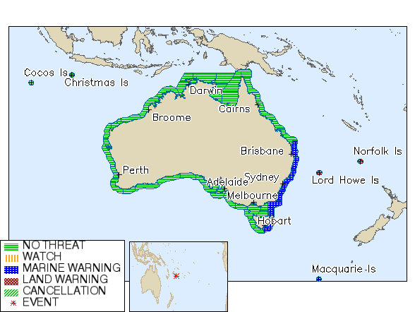
The Australian Bureau of Meteorology (BOM) has issued a tsunami warning for parts of Australia’s east coast including Queensland, New South Wales, Victoria, and Tasmania, as well as Lord Howe, Norfolk, and Macquarie Islands.4
The eruption was heard as far as Fiji, Samoa, Vanuatu and the Cook Islands.
Residents of Fiji and Vanuatu said ground and buildings were shaking for hours.
At this time (13:28 UTC on January 15 / 02:38 LT on January 16 in Tonga), there are no reports of injuries but there are reports of destroyed homes and vehicles.
Electric power and telecommunications are out across Tonga’s main island.
This is one of the most violent eruptions ever captured by satellites.
The volcano started erupting again on December 19, 2021, after 7 years of quiescence (VEI 2). The eruption in 2014, created a new island which is the site of the most recent eruptive activity.5

A high-level eruption took place at 15:29 UTC on January 13, after a quiet period of about two weeks. It was the strongest eruption since December 19 until today.
A Marine Tsunami Warning was issued after 30 cm (1 foot) waves were registered at Nuku’alofa tidal gauges.6

Eruption at Hunga Tonga-Hunga Ha’apai on January 14, 2022. Credit: Tonga Geological Services
Updates
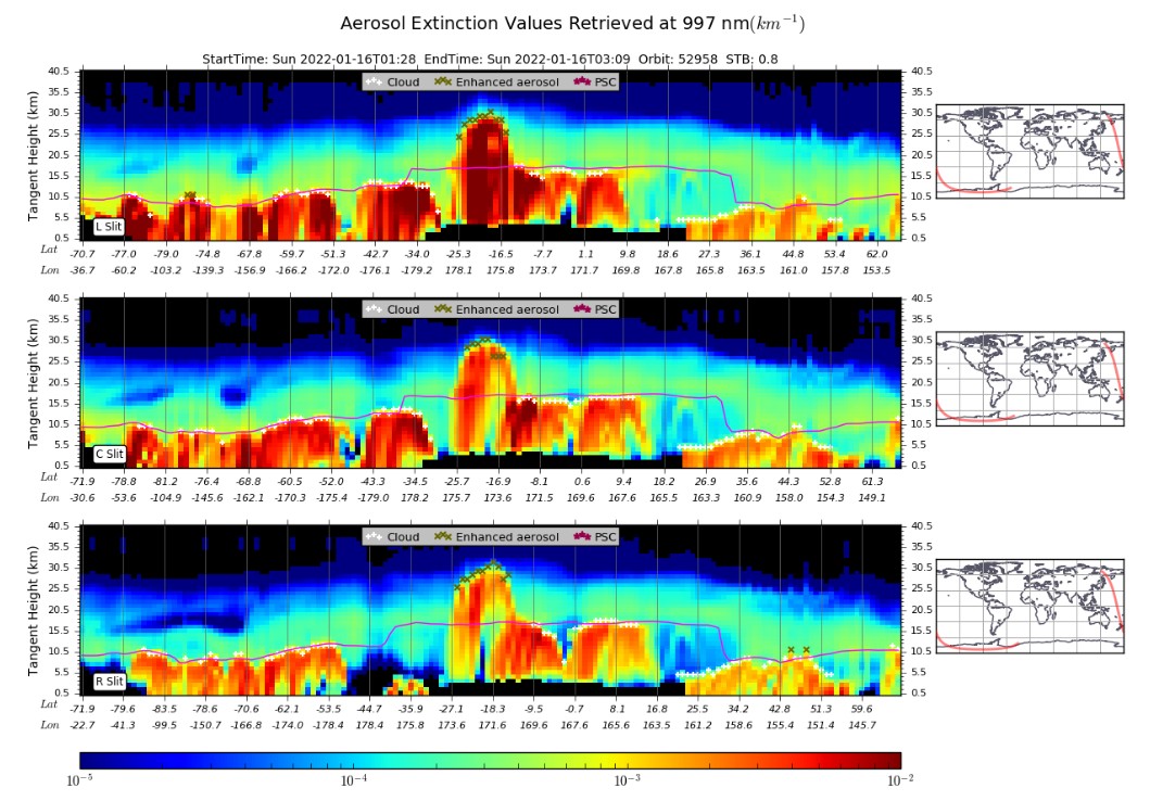
The eruptive column reached a height of about 30 km (98 500 feet) above sea level, according to data provided by the Ozone Mapping and Profiler Suite (OMPS) Limb Profiler aboard the Suomi NPP satellite.
Other estimates suggest the cloud could have reached as high as 39 km (127 900 feet) a.s.l.
While the tsunami caused damage to Nuku’alofa, it was also recorded around the world, from Japan to the United States.
The Japan Meteorological Agency predicted waves as high as 3 m (10 feet), urging nearly 230 000 residents to move to higher grounds. Their warnings were later downgraded to advisories and lifted by 14:00 LT on January 16. Nevertheless, tens of boats either capsized, sank or floated away in several Japanese ports.
Approximately 200 000 lightning strikes were recorded in the first hour of the eruption.
In addition, barometers around the world recorded the pressure wave from the explosion. Pressure waves arrived to Anchorage, Alaska exactly 7 hours after the eruption, suggesting it traveled about 1 340 km/h (830 mph).
People as far away as Australia and Canada heard the sonic boom.
Nuku’alofa was covered in a thick film of volcanic ash.
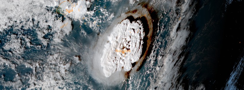
Hunga Tonga-Hunga Ha’apai eruption at 05:00 UTC on January 15, 2022. Credit: NOAA/GOES-WEST, RAMMB/CIRA, TW
Ha’apai suffered major damage after the islands were hit by tsunami waves 5 – 10 meters (16 – 33 feet) in height, reaching 500 meters (1 640 feet) inland. Ha’apai is a group of islands, islets, reefs, and shoals in the central part of Tonga. Their combined population is 5 419.
Electricity and local mobile phone networks have been restored on the main island of Tongatapu but the power connection is not yet stable, the Council for International Development (CID) reported on January 18.
Tonga’s main airport Fua’amotu International Airport is undamaged but heavy ashfall is being cleared and inhibits the airport from being fully operational. The Director of Civil aviation in Tonga advises that the airport runway clearance will take days to complete as this is being conducted manually. The earliest possible clearance is Wednesday, January 19.
Authorities confirmed one fatality in Tonga, a 50-year-old British woman who died after she was washed away while trying to rescue her dogs. Two people died in Peru after tsunami waves reached South America several hours later.
The eruption produced a huge shockwave that circled the planet two times.
Satellite imagery acquired on January 17 confirms the island created during the eruption in 2014/15 was completely destroyed.
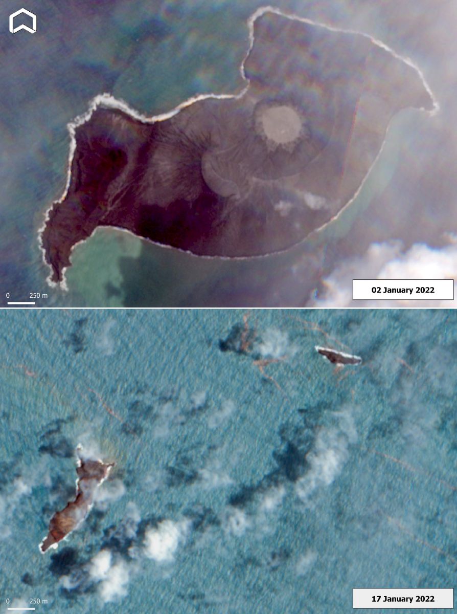
Hunga Tonga-Hunga Ha’apai volcano on January 2 and 17, 2022. Credit: Copernicus EU/Sentinel-2, ADAM Platform
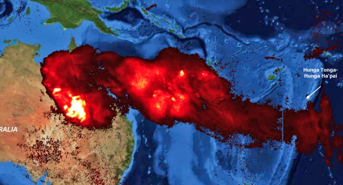
SO2 Total Column on January 17 – produced by the eruption of Hunga Tonga-Hunga Ha’apai volcano on January 15, 2022. Credit: Copernicus EU/Sentinel-5, ADAM Platform
Geological summary
The small islands of Hunga Tonga and Hunga Ha’apai cap a large seamount located about 30 km (18 miles) SSE of Falcon Island.
The two linear andesitic islands are about 2 km (1.2 miles) long and represent the western and northern remnants of the rim of a largely submarine caldera lying east and south of the islands.
Hunga Tonga and Hunga Ha’apai reach an elevation of only 149 m (488 feet) and 128 m (419 feet) above sea level, respectively, and display inward-facing sea cliffs with lava and tephra layers dipping gently away from the submarine caldera.
A rocky shoal 3.2 km (2 miles) SE of Hunga Ha’apai and 3 km (1.8 miles) south of Hunga Tonga marks the most prominent historically active vent.
Several submarine eruptions have occurred at Hunga Tonga-Hunga Ha’apai since the first historical eruption in 1912.7
References:
1 VA ADVISORY DTG: 20220115/1022Z VAAC: WELLINGTON
2 King evacuated as thousands flee for higher ground at Mataki’eua and Fualu height – Kanvitonga
3 Island Business – FB (January 15, 2022)
4 Joint Australian Tsunami Warning Centre – issued at 11:56 PM AEDT on Saturday 15 January 2022
5 High-level eruption at Hunga Tonga-Hunga Ha’apai volcano, Tonga – The Watchers
6 High-level eruption at Hunga Tonga-Hunga Ha’apai, tsunami warning issued, Tonga – The Watchers
7 Hunga Tonga-Hunga Ha’apai – Geological summary – GVP
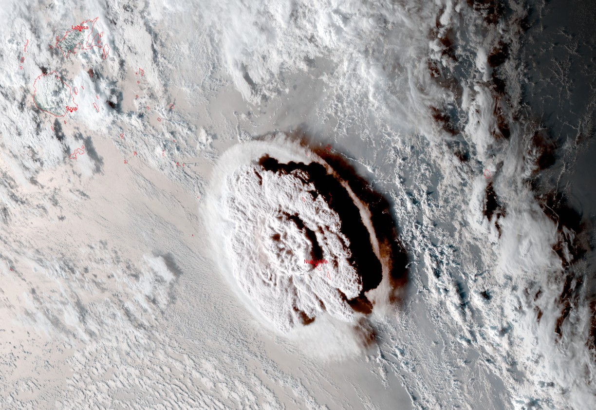
Featured image: Massive eruption at Hunga Tonga-Hunga Ha’apai at 05:10 UTC on January 15, 2022. Credit: JMA/Himawari-8
We heard booms here in Far North Queensland from this volcano.
That’s insane.