Surigae rapidly intensifies into the first Super Typhoon of 2021
Typhoon "Surigae" rapidly intensified on April 16 and 17, 2021, into the first Super Typhoon of the year. Surigae — known in the Philippines as Bising — is expected to become a powerful Category 5 typhoon over the next 12 hours, without making landfall over the Philippines. However, because there are still uncertainties in its track, a westward shift in the current forecast track may result in potentially significant impacts over the eastern portions of Southern Luzon and Visayas.
Surigae entered the Philippine Area of Responsibility (PAR) at 03:00 UTC on April 16 and became a Category 2-equivalent typhoon over the next 12 hours.
As it continued its slow WNW motion toward the Philippines, the typhoon underwent explosive intensification and strengthened to a Category 4-equivalent typhoon by 21:00 UTC on the same day.

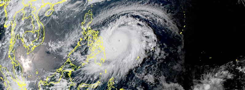
At 06:00 UTC on April 17, its center was located about 490 km (305 miles) NW of Kayangel. Its maximum 10-minute sustained winds were 185 km/h (115 mph) with gusts up to 260 km/h (160 mph) — making it a Super Typhoon.
Maximum 1-minute sustained winds were 240 km/h (150 mph), the minimum central barometric pressure 925 hPa, and the system was moving NW at 20 km/h (15 mph).
Before reaching PAR, Surigae brought strong winds and waves up to 6 m (19.8 feet) to Sitaro Islands Regency, Sangihe Islands Regency, the Talaud Islands, and the northern Molucca Sea, Indonesia.
Micronesia and Palau issued a Tropical Storm Watch for the island of Yap and Ngulu Atoll on April 14, and later modified it into a Tropical Storm Warning for Ngulu Atoll.
Locally heavy rainfall occurred in parts of Palau and Yap for several days. On Thursday, April 15, Surigae dumped 231 mm (9.09 inches) of rain on Koror, Palau's largest city.
In Palau, Surigae brought wind gusts up to 90 km/h (55 mph), causing power outages across the island.
Large swells from the developing storm brought coastal flooding to Koror and Yap whose residents were advised to avoid reef lines in the north and west.

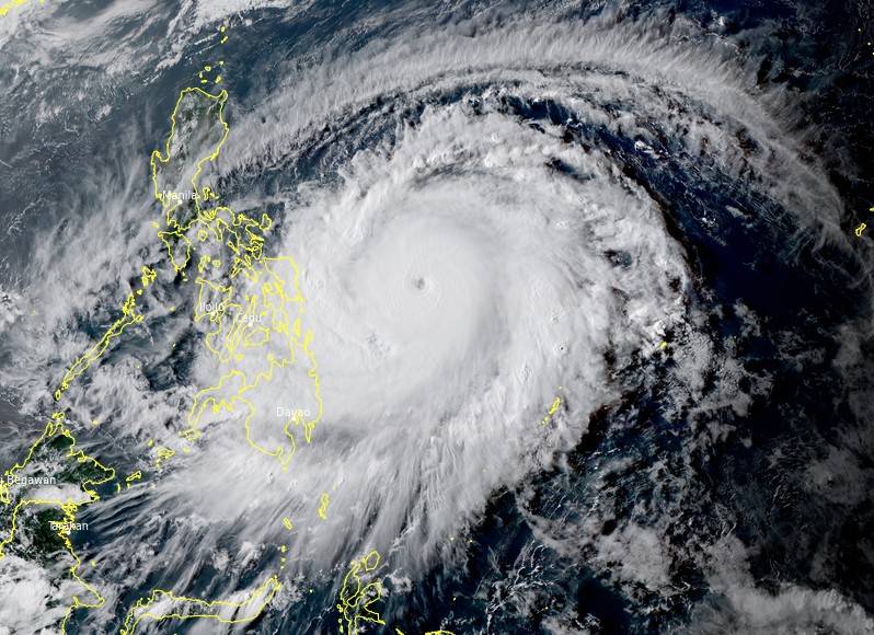
Super Typhoon "Surigae" at 07:50 UTC on April 17, 2021. Credit: JMA/Himawari-8, RAMMB/CIRA, TW
While the typhoon won't make landfall over the Philippines, it will pass close enough to bring strong winds, heavy rains and high seas.
Tomorrow, April 18, Surigae's rainbands will bring moderate to heavy with at times intense rains over Eastern Visayas, Bicol Region, and the southern portion of Quezon.
By Monday, April 19, moderate to heavy with at times intense rains over Northern Samar, Bicol Region, and the southern portion of Quezon.
Under these conditions, flooding (including flash floods) and rain-induced landslides may occur especially in areas identified in hazard maps as highly or very highly susceptible to these hazards.
Tropical cyclone winds of at least a strong breeze to near gale in strength extend outward up to 400 km (250 miles) from the center of the typhoon. Gale-force winds extend outward up to 300 km (185 miles) from the center of the typhoon. Destructive typhoon-force winds extend outward up to 90 km (56 miles) from the center of the typhoon.
Over the next 24 hours, rough to high seas (3 to 10 m / 10 to 33 feet) will be experienced over the eastern seaboards of Luzon and areas where TCWS is in effect while rough to very rough seas (2.8 to 4.5 m / 9 to 15 feet) over the remaining seaboards of Northern Luzon and the eastern seaboards of Mindanao (that are not under TCWS). Sea travel is risky for all types of seacrafts over these waters, especially those under TCWS, PAGASA said.
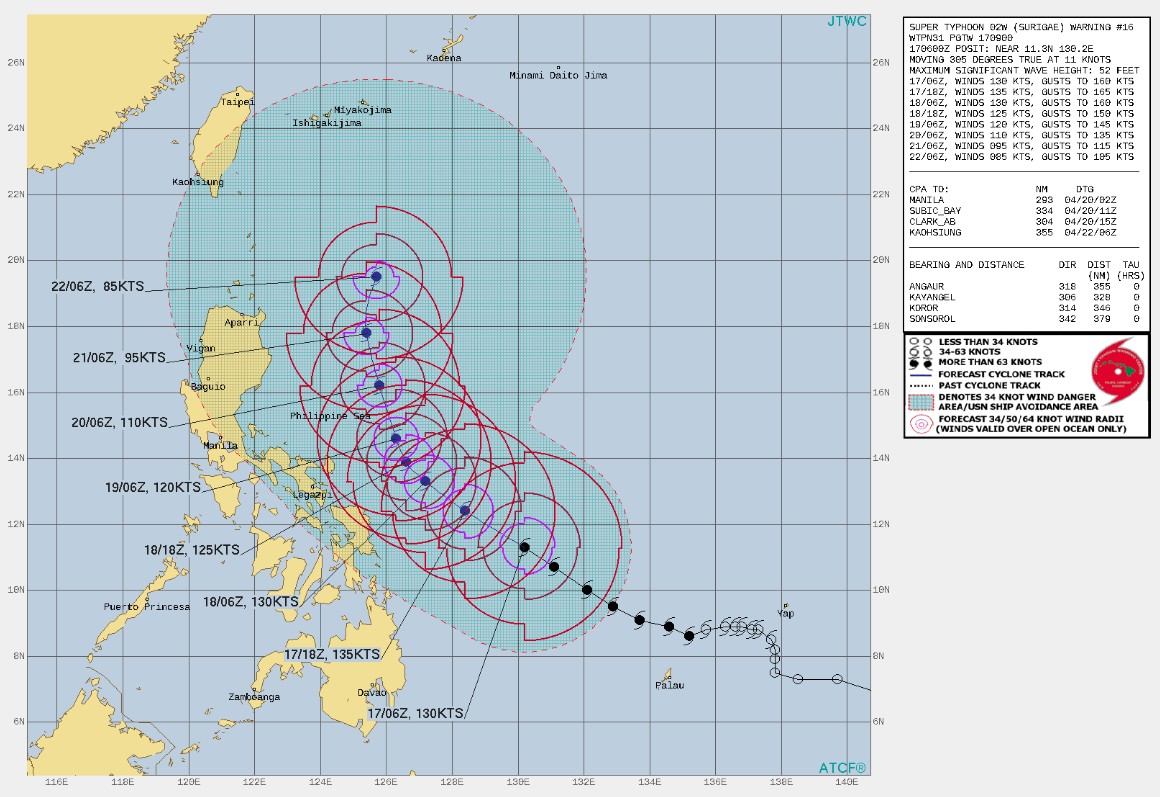
Super Typhoon "Surigae" will move northwestward over the Philippine Sea until tomorrow afternoon (PHT). Afterwards, the typhoon will slow down and move generally northward until Tuesday, April 20 afternoon (LT) before moving generally N or NNW over the Philippine Sea east of Northern and Central Luzon.
Considering the uncertainty in the track forecast, a westward shift in the current forecast track may result in potentially significant impacts over the eastern portions of Southern Luzon and Visayas.
Featured image: Super Typhoon "Surigae" at 07:50 UTC on April 17, 2021. Credit: JMA/Himawari-8, RAMMB/CIRA, TW
Commenting rules and guidelines
We value the thoughts and opinions of our readers and welcome healthy discussions on our website. In order to maintain a respectful and positive community, we ask that all commenters follow these rules:
We reserve the right to remove any comments that violate these rules. By commenting on our website, you agree to abide by these guidelines. Thank you for helping to create a positive and welcoming environment for all.